![](/images/other/stat-length.png)
![Randonnée Vélo Quissac - Quissac-Quissac - Photo](https://media.geolcdn.com/t/1900/400/ext.pjpeg?maxdim=2&url=https%3A%2F%2Fstatic1.geolcdn.com%2Fsiteimages%2Fupload%2Ffiles%2F1524743154velo.jpg)
Quissac-Quissac
bqu34
Utilisateur
![Longueur](/images/other/stat-length.png)
![Altitude max](https://static1.geolcdn.com/siteimages/upload/files/1508320355ic_sort_altitude_max_24dp.png)
![Dénivelé positif](https://static1.geolcdn.com/siteimages/upload/files/1508320355ic_sort_den_pos_24dp.png)
![Km-Effort](/images/other/stat-length.png)
![Altitude min](https://static1.geolcdn.com/siteimages/upload/files/1508320355ic_sort_altitude_min_24dp.png)
![Dénivelé négatif](https://static1.geolcdn.com/siteimages/upload/files/1508320355ic_sort_den_neg_24dp.png)
![Boucle](https://static1.geolcdn.com/siteimages/upload/files/16400158638029165_repeat_loop_refresh_sync_direction_icon.png)
![Vélo](https://static1.geolcdn.com/sitytour/trail-icons/200.png)
7h32
Difficulté : Très facile
![Scannez ce code QR pour ouvrir la randonnée dans l'application SityTrail](https://capi.geolives.com/qq0zvz2zws4bq2lad0pu/sitytour/trails/236474/qr.png?size=200)
Application GPS de randonnée GRATUITE
À propos
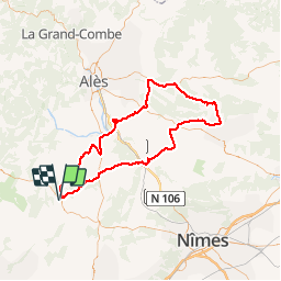
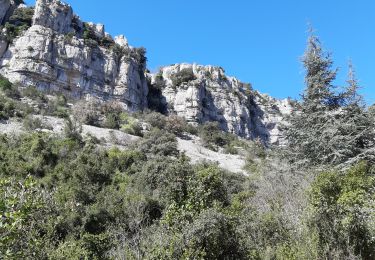
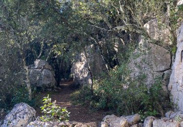
Randonnée Vélo de 114 km à découvrir à Occitanie, Gard, Quissac. Cette randonnée est proposée par bqu34.
Description
Quissac. D35. D24. Logrian (1). Puechredon. Canaules et Argentières. Saint Jean de Serres. D109. D907 vers Lédignan. premier CV à gauche. CV à gauche. Mazac. CV. Lédignan. D6110. Massanes. Vezenobres (2). D116. Saint Etienne de l’Olm. près Euzet. Saint Just. D6. Seynes.D218. Belvezet . Le Mas de la Vieille Eglise (3). D218. D979. D125. Labaume. Mas Pontier (4). Gattigues. Foissac. Collorgues. Saint Dézery. D226. Moussac (5). pont suspendu sur le Gardon. CV. La Réglisserie. Plagnol. D939. D8. Nozières. près Domessargues . D8xD124. D8. premier CV à droite. Fontaries. D724 à gauche . D907 à gauche. D215. D215b à droite. Manthes. D215b. D215bxD6110xCV en face. CV en face. CV à gauche. Savignargues. D8. D194. Saint Théodorit.Quissac.
Localisation
Commentaires
Randonnées à proximité
![Randonnée Marche Quissac - Quissac - Photo](https://media.geolcdn.com/t/375/260/ext.jpg?maxdim=2&url=https%3A%2F%2Fservices.sitytrail.com%2FGeolivesWS%2FDownloadMedia.ashx%3FTrailID%3D233243%26Media%3Dfix__20131117121007.jpg)
![Marche Marche](https://static1.geolcdn.com/sitytour/trail-icons/101.png)
![Randonnée Marche Orthoux-Sérignac-Quilhan - Sérignac - les Mazes - Bragassargues - Photo](https://media.geolcdn.com/t/375/260/ext.jpg?maxdim=2&url=https%3A%2F%2Fstatic1.geolcdn.com%2Fsiteimages%2Fupload%2Ffiles%2F1553511878bg_sport_marche.png)
![Marche Marche](https://static1.geolcdn.com/sitytour/trail-icons/101.png)
Marche
![](/images/other/stat-length.png)
![](https://static1.geolcdn.com/siteimages/upload/files/16400158638029165_repeat_loop_refresh_sync_direction_icon.png)
![Randonnée A pied Liouc - Les chênes de Coutach - Photo](https://media.geolcdn.com/t/375/260/cf45b531-3715-4133-ba5a-b053d48b9be2.jpeg&format=jpg&maxdim=2)
![A pied A pied](https://static1.geolcdn.com/sitytour/trail-icons/100.png)
A pied
![](/images/other/stat-length.png)
![](https://static1.geolcdn.com/siteimages/upload/files/16400158638029165_repeat_loop_refresh_sync_direction_icon.png)
![Randonnée Randonnée équestre Orthoux-Sérignac-Quilhan - mas bas - corconnes en boucle - Photo](https://media.geolcdn.com/t/375/260/debc9152-3802-423a-8c6a-1db256dabcad.jpg&format=jpg&maxdim=2)
![Randonnée équestre Randonnée équestre](https://static1.geolcdn.com/sitytour/trail-icons/301.png)
Randonnée équestre
![](/images/other/stat-length.png)
![](https://static1.geolcdn.com/siteimages/upload/files/16400158638029165_repeat_loop_refresh_sync_direction_icon.png)
![Randonnée Marche Corconne - 30 corconne - Photo](https://media.geolcdn.com/t/375/260/935d2ba4-5725-4112-bf5b-aad99ed037b4.jpg&format=jpg&maxdim=2)
![Marche Marche](https://static1.geolcdn.com/sitytour/trail-icons/101.png)
![Randonnée Marche Sauve - Sauve, le sentier de l'Aven - Photo](https://media.geolcdn.com/t/375/260/ext.jpg?maxdim=2&url=https%3A%2F%2Fstatic1.geolcdn.com%2Fsiteimages%2Fupload%2Ffiles%2F1553511878bg_sport_marche.png)
![Marche Marche](https://static1.geolcdn.com/sitytour/trail-icons/101.png)
Marche
![](/images/other/stat-length.png)
![](https://static1.geolcdn.com/siteimages/upload/files/16400158638029165_repeat_loop_refresh_sync_direction_icon.png)
![Randonnée Marche Corconne - Corconne - Photo](https://media.geolcdn.com/t/375/260/ext.jpg?maxdim=2&url=https%3A%2F%2Fstatic1.geolcdn.com%2Fsiteimages%2Fupload%2Ffiles%2F1553511878bg_sport_marche.png)
![Marche Marche](https://static1.geolcdn.com/sitytour/trail-icons/101.png)
![Randonnée Marche Corconne - CORCONNE - Photo](https://media.geolcdn.com/t/375/260/cec47011-04b4-4f0a-b521-d4e592fe1993.jpg&format=jpg&maxdim=2)
![Marche Marche](https://static1.geolcdn.com/sitytour/trail-icons/101.png)
![Randonnée Marche Corconne - 30 le mazet des gardes Corconne 8/11/23 - Photo](https://media.geolcdn.com/t/375/260/b14cbd76-fce3-469c-9994-e0217aa95e9f.jpg&format=jpg&maxdim=2)
![Marche Marche](https://static1.geolcdn.com/sitytour/trail-icons/101.png)
Marche
![](/images/other/stat-length.png)
![](https://static1.geolcdn.com/siteimages/upload/files/16400158638029165_repeat_loop_refresh_sync_direction_icon.png)