![](/images/other/stat-length.png)
![Randonnée Vélo Longjumeau - Brevet de 200km.](https://media.geolcdn.com/t/1900/400/ext.pjpeg?maxdim=2&url=https%3A%2F%2Fstatic1.geolcdn.com%2Fsiteimages%2Fupload%2Ffiles%2F1524743154velo.jpg)
Brevet de 200km. "La Durocasse"
Lucquiaud
Utilisateur
![Longueur](/images/other/stat-length.png)
Longueur
200 km
![Altitude max](https://static1.geolcdn.com/siteimages/upload/files/1508320355ic_sort_altitude_max_24dp.png)
Altitude max
190 m
![Dénivelé positif](https://static1.geolcdn.com/siteimages/upload/files/1508320355ic_sort_den_pos_24dp.png)
Dénivelé positif
1676 m
![Km-Effort](/images/other/stat-length.png)
Km-Effort
223 km
![Altitude min](https://static1.geolcdn.com/siteimages/upload/files/1508320355ic_sort_altitude_min_24dp.png)
Altitude min
41 m
![Dénivelé négatif](https://static1.geolcdn.com/siteimages/upload/files/1508320355ic_sort_den_neg_24dp.png)
Dénivelé négatif
1676 m
![Boucle](https://static1.geolcdn.com/siteimages/upload/files/16400158638029165_repeat_loop_refresh_sync_direction_icon.png)
Boucle
Oui
Date de création :
2020-03-10 11:13:21.818
Dernière modification :
2020-03-10 11:18:20.015
![Vélo](https://static1.geolcdn.com/sitytour/trail-icons/200.png)
--
Difficulté : Difficile
![Scannez ce code QR pour ouvrir la randonnée dans l'application SityTrail](https://capi.geolives.com/qq0zvz2zws4bq2lad0pu/sitytour/trails/2359323/qr.png?size=200)
Application GPS de randonnée GRATUITE
À propos
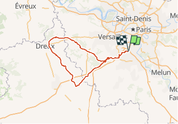
Randonnée Vélo de 200 km à découvrir à Île-de-France, Essonne, Longjumeau. Cette randonnée est proposée par Lucquiaud.
Description
Parcours de 200km. Bevet ACP 3 contrôles: Beveille le Comte - Cherisy - La celle les Bordes. Possibilité de se ravitailler à chaque contrôle.
Localisation
Pays :
France
Région :
Île-de-France
Département/Province :
Essonne
Commune :
Longjumeau
Localité :
Unknown
Départ:(Dec)
Départ:(UTM)
448596 ; 5393630 (31U) N.
Commentaires
Randonnées à proximité
![Randonnée Marche Ballainvilliers - GRP CV-IDF 17R Ballainvilliers à Vauhallan - Photo](https://media.geolcdn.com/t/375/260/0b5967b2-2c8e-4675-a0f7-553186b66225.jpg&format=jpg&maxdim=2)
![Marche Marche](https://static1.geolcdn.com/sitytour/trail-icons/101.png)
GRP CV-IDF 17R Ballainvilliers à Vauhallan
Marche
Très difficile
(1)
Ballainvilliers,
Île-de-France,
Essonne,
France
![](/images/other/stat-length.png)
15,5 km | 19,1 km-effort
4h 20min
![](https://static1.geolcdn.com/siteimages/upload/files/16400158638029165_repeat_loop_refresh_sync_direction_icon.png)
Non
![Randonnée Marche Saulx-les-Chartreux - Saulx les Chartreux vers Ville du Bois - Photo](https://media.geolcdn.com/t/375/260/ext.jpg?maxdim=2&url=https%3A%2F%2Fservices.sitytrail.com%2FGeolivesWS%2FDownloadMedia.ashx%3FTrailID%3D103772%26Media%3D6532_3.jpg)
![Marche Marche](https://static1.geolcdn.com/sitytour/trail-icons/101.png)
Saulx les Chartreux vers Ville du Bois
Marche
Moyen
(1)
Saulx-les-Chartreux,
Île-de-France,
Essonne,
France
![](/images/other/stat-length.png)
9,6 km | 12,2 km-effort
2h 30min
![](https://static1.geolcdn.com/siteimages/upload/files/16400158638029165_repeat_loop_refresh_sync_direction_icon.png)
Oui
![Randonnée Marche Longjumeau - Boucle 23 km autour de Longjumeau - Photo](https://media.geolcdn.com/t/375/260/a98102b6-d183-4b5b-8bb0-fb39230ce35c.jpg&format=jpg&maxdim=2)
![Marche Marche](https://static1.geolcdn.com/sitytour/trail-icons/101.png)
Boucle 23 km autour de Longjumeau
Marche
Moyen
Longjumeau,
Île-de-France,
Essonne,
France
![](/images/other/stat-length.png)
23 km | 27 km-effort
4h 48min
![](https://static1.geolcdn.com/siteimages/upload/files/16400158638029165_repeat_loop_refresh_sync_direction_icon.png)
Oui
![Randonnée A pied Morsang-sur-Orge - Boucle 20 km Morsang sur Orge - Photo](https://media.geolcdn.com/t/375/260/d37a7650-c254-47eb-95bf-21850c3f3dae.jpg&format=jpg&maxdim=2)
![A pied A pied](https://static1.geolcdn.com/sitytour/trail-icons/100.png)
Boucle 20 km Morsang sur Orge
A pied
Facile
Morsang-sur-Orge,
Île-de-France,
Essonne,
France
![](/images/other/stat-length.png)
20 km | 22 km-effort
5h 6min
![](https://static1.geolcdn.com/siteimages/upload/files/16400158638029165_repeat_loop_refresh_sync_direction_icon.png)
Oui
![Randonnée A pied Villebon-sur-Yvette - Grand Tour de Villebon - Photo](https://media.geolcdn.com/t/375/260/078fbd2f-b950-4bef-90d6-cedf1ad93ea0.jpeg&format=jpg&maxdim=2)
![A pied A pied](https://static1.geolcdn.com/sitytour/trail-icons/100.png)
Grand Tour de Villebon
A pied
Facile
(1)
Villebon-sur-Yvette,
Île-de-France,
Essonne,
France
![](/images/other/stat-length.png)
13,1 km | 15,6 km-effort
3h 32min
![](https://static1.geolcdn.com/siteimages/upload/files/16400158638029165_repeat_loop_refresh_sync_direction_icon.png)
Oui
![Randonnée A pied Palaiseau - PR 11 - Photo](https://media.geolcdn.com/t/375/260/1554c568-abca-4e73-a183-09d30e34ef31.jpeg&format=jpg&maxdim=2)
![A pied A pied](https://static1.geolcdn.com/sitytour/trail-icons/100.png)
![Randonnée Marche Longjumeau - Le pont des templiers - Photo](https://media.geolcdn.com/t/375/260/47ca11fe-9e23-483d-8b98-cc620d4b03d7.jpg&format=jpg&maxdim=2)
![Marche Marche](https://static1.geolcdn.com/sitytour/trail-icons/101.png)
Le pont des templiers
Marche
Moyen
Longjumeau,
Île-de-France,
Essonne,
France
![](/images/other/stat-length.png)
15,4 km | 17,2 km-effort
3h 56min
![](https://static1.geolcdn.com/siteimages/upload/files/16400158638029165_repeat_loop_refresh_sync_direction_icon.png)
Oui
![Randonnée Marche Palaiseau - Yvette et fort de Palaiseau - Photo](https://media.geolcdn.com/t/375/260/ext.jpg?maxdim=2&url=https%3A%2F%2Fstatic1.geolcdn.com%2Fsiteimages%2Fupload%2Ffiles%2F1553511878bg_sport_marche.png)
![Marche Marche](https://static1.geolcdn.com/sitytour/trail-icons/101.png)
Yvette et fort de Palaiseau
Marche
Difficile
(1)
Palaiseau,
Île-de-France,
Essonne,
France
![](/images/other/stat-length.png)
10,1 km | 12,3 km-effort
2h 48min
![](https://static1.geolcdn.com/siteimages/upload/files/16400158638029165_repeat_loop_refresh_sync_direction_icon.png)
Oui
![Randonnée Marche Longjumeau - La rivière morte - Photo](https://media.geolcdn.com/t/375/260/0639c636-16c8-4a86-9159-a268a730aa8b.jpg&format=jpg&maxdim=2)
![Marche Marche](https://static1.geolcdn.com/sitytour/trail-icons/101.png)
La rivière morte
Marche
Moyen
Longjumeau,
Île-de-France,
Essonne,
France
![](/images/other/stat-length.png)
14,8 km | 16,8 km-effort
3h 49min
![](https://static1.geolcdn.com/siteimages/upload/files/16400158638029165_repeat_loop_refresh_sync_direction_icon.png)
Non