![](/images/other/stat-length.png)
![Randonnée Marche Plateau d'Hauteville - 2020-03-04 Plan d'eau des Lésines - Photo](https://media.geolcdn.com/t/1900/400/ext.pjpeg?maxdim=2&url=https%3A%2F%2Fstatic1.geolcdn.com%2Fsiteimages%2Fupload%2Ffiles%2F1553511878bg_sport_marche.png)
2020-03-04 Plan d'eau des Lésines
patpounet73
Utilisateur
![Longueur](/images/other/stat-length.png)
Longueur
8,1 km
![Altitude max](https://static1.geolcdn.com/siteimages/upload/files/1508320355ic_sort_altitude_max_24dp.png)
Altitude max
828 m
![Dénivelé positif](https://static1.geolcdn.com/siteimages/upload/files/1508320355ic_sort_den_pos_24dp.png)
Dénivelé positif
139 m
![Km-Effort](/images/other/stat-length.png)
Km-Effort
9,9 km
![Altitude min](https://static1.geolcdn.com/siteimages/upload/files/1508320355ic_sort_altitude_min_24dp.png)
Altitude min
733 m
![Dénivelé négatif](https://static1.geolcdn.com/siteimages/upload/files/1508320355ic_sort_den_neg_24dp.png)
Dénivelé négatif
140 m
![Boucle](https://static1.geolcdn.com/siteimages/upload/files/16400158638029165_repeat_loop_refresh_sync_direction_icon.png)
Boucle
Oui
Date de création :
2020-03-04 14:38:15.513
Dernière modification :
2020-03-05 09:17:31.046
![Marche](https://static1.geolcdn.com/sitytour/trail-icons/101.png)
2h00
Difficulté : Facile
![Scannez ce code QR pour ouvrir la randonnée dans l'application SityTrail](https://capi.geolives.com/qq0zvz2zws4bq2lad0pu/sitytour/trails/2353863/qr.png?size=200)
Application GPS de randonnée GRATUITE
À propos
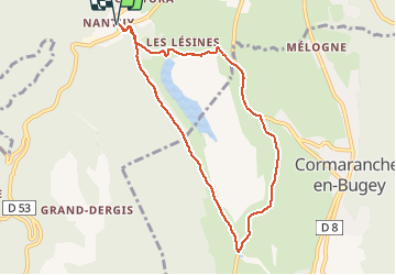
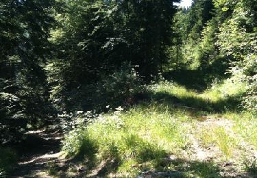
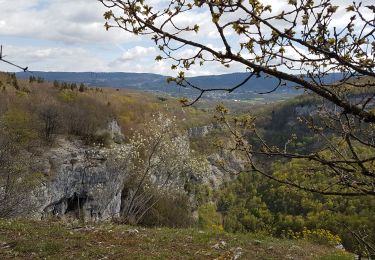
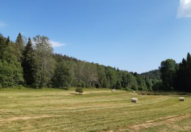
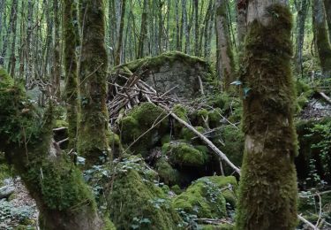
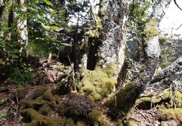
Randonnée Marche de 8,1 km à découvrir à Auvergne-Rhône-Alpes, Ain, Plateau d'Hauteville. Cette randonnée est proposée par patpounet73.
Description
Le temps est couvert, c'est pourquoi nous avons fait la boucle en marche rapide. Prévoir 3h00 pour profiter de ce circuit agréable qui ne présente aucune difficulté.
Localisation
Pays :
France
Région :
Auvergne-Rhône-Alpes
Département/Province :
Ain
Commune :
Plateau d'Hauteville
Localité :
Hauteville-Lompnes
Départ:(Dec)
Départ:(UTM)
699559 ; 5093718 (31T) N.
Commentaires
Randonnées à proximité
![Randonnée V.T.T. Plateau d'Hauteville - Espace VTT FFC du Bugey - Circuit n° 01 - Photo](https://media.geolcdn.com/t/375/260/ext.jpg?maxdim=2&url=https%3A%2F%2Fservices.sitytrail.com%2FGeolivesWS%2FDownloadMedia.ashx%3FTrailID%3D101872%26Media%3D2159_1.jpg)
![V.T.T. V.T.T.](https://static1.geolcdn.com/sitytour/trail-icons/202.png)
Espace VTT FFC du Bugey - Circuit n° 01
V.T.T.
Facile
(1)
Plateau d'Hauteville,
Auvergne-Rhône-Alpes,
Ain,
France
![](/images/other/stat-length.png)
12,5 km | 15,2 km-effort
1h 0min
![](https://static1.geolcdn.com/siteimages/upload/files/16400158638029165_repeat_loop_refresh_sync_direction_icon.png)
Oui
![Randonnée Marche Plateau d'Hauteville - 01 Hautville Belvédère Planachat - Photo](https://media.geolcdn.com/t/375/260/ext.jpg?maxdim=2&url=https%3A%2F%2Fstatic1.geolcdn.com%2Fsiteimages%2Fupload%2Ffiles%2F1553511878bg_sport_marche.png)
![Marche Marche](https://static1.geolcdn.com/sitytour/trail-icons/101.png)
01 Hautville Belvédère Planachat
Marche
Difficile
(1)
Plateau d'Hauteville,
Auvergne-Rhône-Alpes,
Ain,
France
![](/images/other/stat-length.png)
10,8 km | 17,1 km-effort
3h 53min
![](https://static1.geolcdn.com/siteimages/upload/files/16400158638029165_repeat_loop_refresh_sync_direction_icon.png)
Oui
![Randonnée Marche nordique Plateau d'Hauteville - cormaranche 20220326 - Photo](https://media.geolcdn.com/t/375/260/c23bf53a-5142-45d1-b749-fa8e16ce1231.jpg&format=jpg&maxdim=2)
![Marche nordique Marche nordique](https://static1.geolcdn.com/sitytour/trail-icons/102.png)
cormaranche 20220326
Marche nordique
Difficile
Plateau d'Hauteville,
Auvergne-Rhône-Alpes,
Ain,
France
![](/images/other/stat-length.png)
11,4 km | 20 km-effort
2h 23min
![](https://static1.geolcdn.com/siteimages/upload/files/16400158638029165_repeat_loop_refresh_sync_direction_icon.png)
Non
![Randonnée Marche nordique Plateau d'Hauteville - cormaranche20220321 - Photo](https://media.geolcdn.com/t/375/260/006a3545-b0f2-4e00-bf7b-e5599191d1d6.jpg&format=jpg&maxdim=2)
![Marche nordique Marche nordique](https://static1.geolcdn.com/sitytour/trail-icons/102.png)
cormaranche20220321
Marche nordique
Difficile
Plateau d'Hauteville,
Auvergne-Rhône-Alpes,
Ain,
France
![](/images/other/stat-length.png)
7,1 km | 12,9 km-effort
1h 17min
![](https://static1.geolcdn.com/siteimages/upload/files/16400158638029165_repeat_loop_refresh_sync_direction_icon.png)
Oui
![Randonnée Marche Plateau d'Hauteville - Planachat - Photo](https://media.geolcdn.com/t/375/260/ext.jpg?maxdim=2&url=https%3A%2F%2Fservices.sitytrail.com%2FGeolivesWS%2FDownloadMedia.ashx%3FTrailID%3D42061%26Media%3Dimage5.jpg)
![Marche Marche](https://static1.geolcdn.com/sitytour/trail-icons/101.png)
Planachat
Marche
Très facile
(1)
Plateau d'Hauteville,
Auvergne-Rhône-Alpes,
Ain,
France
![](/images/other/stat-length.png)
7,8 km | 12,3 km-effort
1h 49min
![](https://static1.geolcdn.com/siteimages/upload/files/16400158638029165_repeat_loop_refresh_sync_direction_icon.png)
Oui
![Randonnée Marche Plateau d'Hauteville - Nantuy La Berche - Photo](https://media.geolcdn.com/t/375/260/d8589a16-c9ea-4909-9799-d99681ccb007.jpg&format=jpg&maxdim=2)
![Marche Marche](https://static1.geolcdn.com/sitytour/trail-icons/101.png)
Nantuy La Berche
Marche
Moyen
Plateau d'Hauteville,
Auvergne-Rhône-Alpes,
Ain,
France
![](/images/other/stat-length.png)
15,3 km | 21 km-effort
4h 31min
![](https://static1.geolcdn.com/siteimages/upload/files/16400158638029165_repeat_loop_refresh_sync_direction_icon.png)
Oui
![Randonnée Marche Plateau d'Hauteville - Chemin de crête de Valorse - Photo](https://media.geolcdn.com/t/375/260/cb405710-9611-4e37-ab00-4c6b5ca1dd4d.jpg&format=jpg&maxdim=2)
![Marche Marche](https://static1.geolcdn.com/sitytour/trail-icons/101.png)
Chemin de crête de Valorse
Marche
Moyen
Plateau d'Hauteville,
Auvergne-Rhône-Alpes,
Ain,
France
![](/images/other/stat-length.png)
4,7 km | 6,2 km-effort
1h 41min
![](https://static1.geolcdn.com/siteimages/upload/files/16400158638029165_repeat_loop_refresh_sync_direction_icon.png)
Oui
![Randonnée Marche Chaley - Albarine à Chaley - Photo](https://media.geolcdn.com/t/375/260/04f934c9-c846-458a-83c5-98abc05198c1.jpg&format=jpg&maxdim=2)
![Marche Marche](https://static1.geolcdn.com/sitytour/trail-icons/101.png)
Albarine à Chaley
Marche
Très facile
Chaley,
Auvergne-Rhône-Alpes,
Ain,
France
![](/images/other/stat-length.png)
5,9 km | 7,4 km-effort
2h 57min
![](https://static1.geolcdn.com/siteimages/upload/files/16400158638029165_repeat_loop_refresh_sync_direction_icon.png)
Oui
![Randonnée Marche Plateau d'Hauteville - Chemin des Crêtes La Praille - Photo](https://media.geolcdn.com/t/375/260/8dc776ce-fe51-4c6a-9fae-b4fd9b27fa75.jpg&format=jpg&maxdim=2)
![Marche Marche](https://static1.geolcdn.com/sitytour/trail-icons/101.png)
Chemin des Crêtes La Praille
Marche
Moyen
Plateau d'Hauteville,
Auvergne-Rhône-Alpes,
Ain,
France
![](/images/other/stat-length.png)
5,6 km | 7,8 km-effort
2h 1min
![](https://static1.geolcdn.com/siteimages/upload/files/16400158638029165_repeat_loop_refresh_sync_direction_icon.png)
Oui