![](/images/other/stat-length.png)
![Randonnée Marche Chantonnay - Sentier des Passerelles - Chantonnay - Photo](https://media.geolcdn.com/t/1900/400/ext.pjpeg?maxdim=2&url=https%3A%2F%2Fstatic1.geolcdn.com%2Fsiteimages%2Fupload%2Ffiles%2F1553511878bg_sport_marche.png)
Sentier des Passerelles - Chantonnay
neoroll44
Utilisateur
![Longueur](/images/other/stat-length.png)
Longueur
12,7 km
![Altitude max](https://static1.geolcdn.com/siteimages/upload/files/1508320355ic_sort_altitude_max_24dp.png)
Altitude max
111 m
![Dénivelé positif](https://static1.geolcdn.com/siteimages/upload/files/1508320355ic_sort_den_pos_24dp.png)
Dénivelé positif
191 m
![Km-Effort](/images/other/stat-length.png)
Km-Effort
15,2 km
![Altitude min](https://static1.geolcdn.com/siteimages/upload/files/1508320355ic_sort_altitude_min_24dp.png)
Altitude min
37 m
![Dénivelé négatif](https://static1.geolcdn.com/siteimages/upload/files/1508320355ic_sort_den_neg_24dp.png)
Dénivelé négatif
192 m
![Boucle](https://static1.geolcdn.com/siteimages/upload/files/16400158638029165_repeat_loop_refresh_sync_direction_icon.png)
Boucle
Oui
Date de création :
2020-02-29 18:31:45.032
Dernière modification :
2020-02-29 18:32:27.929
![Marche](https://static1.geolcdn.com/sitytour/trail-icons/101.png)
3h18
Difficulté : Difficile
![Scannez ce code QR pour ouvrir la randonnée dans l'application SityTrail](https://capi.geolives.com/qq0zvz2zws4bq2lad0pu/sitytour/trails/2350027/qr.png?size=200)
Application GPS de randonnée GRATUITE
À propos
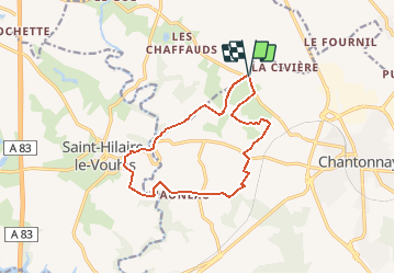
Randonnée Marche de 12,7 km à découvrir à Pays de la Loire, Vendée, Chantonnay. Cette randonnée est proposée par neoroll44.
Description
Départ : Village de la Marzelle
Distance : 12,7 km
Signalétique : Sentier n°5 - Couleur Noire
A découvrir :
- Le lavoir de la Culère - Le chêne de la Mainborgère - Le point de vue sur le petit Lay - Le Château de L'Auneau
Localisation
Pays :
France
Région :
Pays de la Loire
Département/Province :
Vendée
Commune :
Chantonnay
Localité :
Unknown
Départ:(Dec)
Départ:(UTM)
646400 ; 5174192 (30T) N.
Commentaires
Randonnées à proximité
![Randonnée Autre activité Chantonnay - Circuit du lac de l'Angle Guignard - Chantonnay - Photo](https://media.geolcdn.com/t/375/260/ext.jpg?maxdim=2&url=http%3A%2F%2Ffichier1.cirkwi.com%2Fimage%2Fphoto%2Fpoi%2F1300x1300%2F62839%2Ffr%2F0.jpg)
![Autre activité Autre activité](https://static1.geolcdn.com/sitytour/trail-icons/900.png)
Circuit du lac de l'Angle Guignard - Chantonnay
Autre activité
Très facile
Chantonnay,
Pays de la Loire,
Vendée,
France
![](/images/other/stat-length.png)
13,9 km | 17,6 km-effort
Inconnu
![](https://static1.geolcdn.com/siteimages/upload/files/16400158638029165_repeat_loop_refresh_sync_direction_icon.png)
Oui
![Randonnée V.T.T. Sainte-Cécile - Sainte-Cécile 2024 - Photo](https://media.geolcdn.com/t/375/260/ext.jpg?maxdim=2&url=https%3A%2F%2Fstatic1.geolcdn.com%2Fsiteimages%2Fupload%2Ffiles%2F1524743154velo.jpg)
![V.T.T. V.T.T.](https://static1.geolcdn.com/sitytour/trail-icons/202.png)
Sainte-Cécile 2024
V.T.T.
Difficile
Sainte-Cécile,
Pays de la Loire,
Vendée,
France
![](/images/other/stat-length.png)
32 km | 37 km-effort
2h 32min
![](https://static1.geolcdn.com/siteimages/upload/files/16400158638029165_repeat_loop_refresh_sync_direction_icon.png)
Oui
![Randonnée Marche Chantonnay - Chantonnay - La Jaudonniere - Photo](https://media.geolcdn.com/t/375/260/defc772f-a5e9-44e0-b4dd-5c91f360d21c.jpg&format=jpg&maxdim=2)
![Marche Marche](https://static1.geolcdn.com/sitytour/trail-icons/101.png)
Chantonnay - La Jaudonniere
Marche
Difficile
Chantonnay,
Pays de la Loire,
Vendée,
France
![](/images/other/stat-length.png)
14 km | 16,7 km-effort
3h 11min
![](https://static1.geolcdn.com/siteimages/upload/files/16400158638029165_repeat_loop_refresh_sync_direction_icon.png)
Non
![Randonnée Marche Chantonnay - GR364-Jour n° 5 - Photo](https://media.geolcdn.com/t/375/260/ext.jpg?maxdim=2&url=https%3A%2F%2Fstatic1.geolcdn.com%2Fsiteimages%2Fupload%2Ffiles%2F1553511878bg_sport_marche.png)
![Marche Marche](https://static1.geolcdn.com/sitytour/trail-icons/101.png)
GR364-Jour n° 5
Marche
Très difficile
Chantonnay,
Pays de la Loire,
Vendée,
France
![](/images/other/stat-length.png)
25 km | 30 km-effort
6h 49min
![](https://static1.geolcdn.com/siteimages/upload/files/16400158638029165_repeat_loop_refresh_sync_direction_icon.png)
Non
![Randonnée Marche Chantonnay - Chantonnay la caillere st hilaire - Photo](https://media.geolcdn.com/t/375/260/ext.jpg?maxdim=2&url=https%3A%2F%2Fstatic1.geolcdn.com%2Fsiteimages%2Fupload%2Ffiles%2F1553511878bg_sport_marche.png)
![Marche Marche](https://static1.geolcdn.com/sitytour/trail-icons/101.png)
Chantonnay la caillere st hilaire
Marche
Moyen
Chantonnay,
Pays de la Loire,
Vendée,
France
![](/images/other/stat-length.png)
20 km | 24 km-effort
6h 16min
![](https://static1.geolcdn.com/siteimages/upload/files/16400158638029165_repeat_loop_refresh_sync_direction_icon.png)
Non
![Randonnée Vélo de route Chantonnay - Plaine de Chantonnay et Château d'eau de la Vendée - Photo](https://media.geolcdn.com/t/375/260/ext.jpg?maxdim=2&url=https%3A%2F%2Fstatic1.geolcdn.com%2Fsiteimages%2Fupload%2Ffiles%2F1524743154velo.jpg)
![Vélo de route Vélo de route](https://static1.geolcdn.com/sitytour/trail-icons/201.png)
Plaine de Chantonnay et Château d'eau de la Vendée
Vélo de route
Moyen
Chantonnay,
Pays de la Loire,
Vendée,
France
![](/images/other/stat-length.png)
59 km | 68 km-effort
3h 59min
![](https://static1.geolcdn.com/siteimages/upload/files/16400158638029165_repeat_loop_refresh_sync_direction_icon.png)
Oui
![Randonnée Marche Chantonnay - Sentier de la Nouette - Chantonnay - Photo](https://media.geolcdn.com/t/375/260/ext.jpg?maxdim=2&url=https%3A%2F%2Fstatic1.geolcdn.com%2Fsiteimages%2Fupload%2Ffiles%2F1553511878bg_sport_marche.png)
![Marche Marche](https://static1.geolcdn.com/sitytour/trail-icons/101.png)
Sentier de la Nouette - Chantonnay
Marche
Difficile
Chantonnay,
Pays de la Loire,
Vendée,
France
![](/images/other/stat-length.png)
12,5 km | 15,2 km-effort
3h 17min
![](https://static1.geolcdn.com/siteimages/upload/files/16400158638029165_repeat_loop_refresh_sync_direction_icon.png)
Oui
![Randonnée Marche Chantonnay - Circuit du lac de l'Angle Guignard - Chantonnay - Photo](https://media.geolcdn.com/t/375/260/ext.jpg?maxdim=2&url=https%3A%2F%2Fstatic1.geolcdn.com%2Fsiteimages%2Fupload%2Ffiles%2F1553511878bg_sport_marche.png)
![Marche Marche](https://static1.geolcdn.com/sitytour/trail-icons/101.png)
Circuit du lac de l'Angle Guignard - Chantonnay
Marche
Difficile
Chantonnay,
Pays de la Loire,
Vendée,
France
![](/images/other/stat-length.png)
13,9 km | 17,6 km-effort
3h 47min
![](https://static1.geolcdn.com/siteimages/upload/files/16400158638029165_repeat_loop_refresh_sync_direction_icon.png)
Oui
![Randonnée Marche Chantonnay - Sentier de Puybelliard par Ponsay - Chantonnay - Photo](https://media.geolcdn.com/t/375/260/ext.jpg?maxdim=2&url=https%3A%2F%2Fstatic1.geolcdn.com%2Fsiteimages%2Fupload%2Ffiles%2F1553511878bg_sport_marche.png)
![Marche Marche](https://static1.geolcdn.com/sitytour/trail-icons/101.png)
Sentier de Puybelliard par Ponsay - Chantonnay
Marche
Moyen
Chantonnay,
Pays de la Loire,
Vendée,
France
![](/images/other/stat-length.png)
10,3 km | 11,7 km-effort
2h 35min
![](https://static1.geolcdn.com/siteimages/upload/files/16400158638029165_repeat_loop_refresh_sync_direction_icon.png)
Oui