![](/images/other/stat-length.png)
![Randonnée A pied Prédefin - Prédefin - Photo](https://media.geolcdn.com/t/1900/400/ext.pjpeg?maxdim=2&url=https%3A%2F%2Fstatic1.geolcdn.com%2Fsiteimages%2Fupload%2Ffiles%2F1545311037marcheuse_200dpi.jpg)
Prédefin
Yonal62
Utilisateur
![Longueur](/images/other/stat-length.png)
Longueur
13,8 km
![Altitude max](https://static1.geolcdn.com/siteimages/upload/files/1508320355ic_sort_altitude_max_24dp.png)
Altitude max
176 m
![Dénivelé positif](https://static1.geolcdn.com/siteimages/upload/files/1508320355ic_sort_den_pos_24dp.png)
Dénivelé positif
167 m
![Km-Effort](/images/other/stat-length.png)
Km-Effort
16 km
![Altitude min](https://static1.geolcdn.com/siteimages/upload/files/1508320355ic_sort_altitude_min_24dp.png)
Altitude min
75 m
![Dénivelé négatif](https://static1.geolcdn.com/siteimages/upload/files/1508320355ic_sort_den_neg_24dp.png)
Dénivelé négatif
167 m
![Boucle](https://static1.geolcdn.com/siteimages/upload/files/16400158638029165_repeat_loop_refresh_sync_direction_icon.png)
Boucle
Oui
Date de création :
2020-02-24 08:24:33.955
Dernière modification :
2020-02-24 08:28:13.205
![A pied](https://static1.geolcdn.com/sitytour/trail-icons/100.png)
--
Difficulté : Facile
![Scannez ce code QR pour ouvrir la randonnée dans l'application SityTrail](https://capi.geolives.com/qq0zvz2zws4bq2lad0pu/sitytour/trails/2344645/qr.png?size=200)
Application GPS de randonnée GRATUITE
À propos
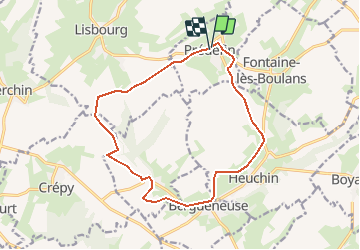
Randonnée A pied de 13,8 km à découvrir à Hauts-de-France, Pas-de-Calais, Prédefin. Cette randonnée est proposée par Yonal62.
Description
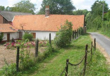
Balade avec une découverte de petits villages ruraux où de belles surprises patrimoniales vous attendent.
Localisation
Pays :
France
Région :
Hauts-de-France
Département/Province :
Pas-de-Calais
Commune :
Prédefin
Localité :
Unknown
Départ:(Dec)
Départ:(UTM)
447129 ; 5594829 (31U) N.
Commentaires
Randonnées à proximité
![Randonnée Moteur Bergueneuse - 6e Artois dimanche - Photo](https://media.geolcdn.com/t/375/260/ext.jpg?maxdim=2&url=https%3A%2F%2Fstatic1.geolcdn.com%2Fsiteimages%2Fupload%2Ffiles%2F15247431544x4.jpg)
![Moteur Moteur](https://static1.geolcdn.com/sitytour/trail-icons/400.png)
6e Artois dimanche
Moteur
Moyen
(2)
Bergueneuse,
Hauts-de-France,
Pas-de-Calais,
France
![](/images/other/stat-length.png)
233 km | 271 km-effort
8h 52min
![](https://static1.geolcdn.com/siteimages/upload/files/16400158638029165_repeat_loop_refresh_sync_direction_icon.png)
Non
![Randonnée Marche Febvin-Palfart - La boucle du puits sans fond - Photo](https://media.geolcdn.com/t/375/260/ext.jpg?maxdim=2&url=https%3A%2F%2Fservices.sitytrail.com%2FGeolivesWS%2FDownloadMedia.ashx%3FTrailID%3D109743%26Media%3D4547_6.jpg)
![Marche Marche](https://static1.geolcdn.com/sitytour/trail-icons/101.png)
La boucle du puits sans fond
Marche
Moyen
Febvin-Palfart,
Hauts-de-France,
Pas-de-Calais,
France
![](/images/other/stat-length.png)
9,5 km | 11,6 km-effort
2h 15min
![](https://static1.geolcdn.com/siteimages/upload/files/16400158638029165_repeat_loop_refresh_sync_direction_icon.png)
Oui
![Randonnée Marche Fontaine-lès-Boulans - Boucle de 23km au départ de Fontaine les Boulans - Photo](https://media.geolcdn.com/t/375/260/ext.jpg?maxdim=2&url=https%3A%2F%2Fstatic1.geolcdn.com%2Fsiteimages%2Fupload%2Ffiles%2F1553511878bg_sport_marche.png)
![Marche Marche](https://static1.geolcdn.com/sitytour/trail-icons/101.png)
Boucle de 23km au départ de Fontaine les Boulans
Marche
Très difficile
Fontaine-lès-Boulans,
Hauts-de-France,
Pas-de-Calais,
France
![](/images/other/stat-length.png)
23 km | 26 km-effort
6h 1min
![](https://static1.geolcdn.com/siteimages/upload/files/16400158638029165_repeat_loop_refresh_sync_direction_icon.png)
Oui
![Randonnée A pied Febvin-Palfart - FEBVIN PALVART 23 km - Photo](https://media.geolcdn.com/t/375/260/ext.jpg?maxdim=2&url=https%3A%2F%2Fstatic1.geolcdn.com%2Fsiteimages%2Fupload%2Ffiles%2F1545311037marcheuse_200dpi.jpg)
![A pied A pied](https://static1.geolcdn.com/sitytour/trail-icons/100.png)
FEBVIN PALVART 23 km
A pied
Moyen
Febvin-Palfart,
Hauts-de-France,
Pas-de-Calais,
France
![](/images/other/stat-length.png)
23 km | 27 km-effort
5h 0min
![](https://static1.geolcdn.com/siteimages/upload/files/16400158638029165_repeat_loop_refresh_sync_direction_icon.png)
Oui
![Randonnée Marche Fontaine-lès-Boulans - fontaine les boulans - Photo](https://media.geolcdn.com/t/375/260/ext.jpg?maxdim=2&url=https%3A%2F%2Fstatic1.geolcdn.com%2Fsiteimages%2Fupload%2Ffiles%2F1553511878bg_sport_marche.png)
![Marche Marche](https://static1.geolcdn.com/sitytour/trail-icons/101.png)
fontaine les boulans
Marche
Moyen
Fontaine-lès-Boulans,
Hauts-de-France,
Pas-de-Calais,
France
![](/images/other/stat-length.png)
30 km | 35 km-effort
7h 34min
![](https://static1.geolcdn.com/siteimages/upload/files/16400158638029165_repeat_loop_refresh_sync_direction_icon.png)
Non
![Randonnée Marche Verchin - Verchin - Photo](https://media.geolcdn.com/t/375/260/ext.jpg?maxdim=2&url=https%3A%2F%2Fstatic1.geolcdn.com%2Fsiteimages%2Fupload%2Ffiles%2F1553511878bg_sport_marche.png)
![Marche Marche](https://static1.geolcdn.com/sitytour/trail-icons/101.png)
Verchin
Marche
Moyen
Verchin,
Hauts-de-France,
Pas-de-Calais,
France
![](/images/other/stat-length.png)
18,8 km | 22 km-effort
4h 32min
![](https://static1.geolcdn.com/siteimages/upload/files/16400158638029165_repeat_loop_refresh_sync_direction_icon.png)
Oui
![Randonnée Randonnée équestre Équirre - j1 Equirandos - Photo](https://media.geolcdn.com/t/375/260/ext.jpg?maxdim=2&url=https%3A%2F%2Fstatic1.geolcdn.com%2Fsiteimages%2Fupload%2Ffiles%2F1524743154cheval.jpg)
![Randonnée équestre Randonnée équestre](https://static1.geolcdn.com/sitytour/trail-icons/301.png)
j1 Equirandos
Randonnée équestre
Moyen
Équirre,
Hauts-de-France,
Pas-de-Calais,
France
![](/images/other/stat-length.png)
20 km | 23 km-effort
3h 50min
![](https://static1.geolcdn.com/siteimages/upload/files/16400158638029165_repeat_loop_refresh_sync_direction_icon.png)
Non
![Randonnée Randonnée équestre Équirre - Equirando J1 lundi Equirre-Blangy sur Ternoise - Photo](https://media.geolcdn.com/t/375/260/ext.jpg?maxdim=2&url=https%3A%2F%2Fstatic1.geolcdn.com%2Fsiteimages%2Fupload%2Ffiles%2F1524743154cheval.jpg)
![Randonnée équestre Randonnée équestre](https://static1.geolcdn.com/sitytour/trail-icons/301.png)
Equirando J1 lundi Equirre-Blangy sur Ternoise
Randonnée équestre
Moyen
Équirre,
Hauts-de-France,
Pas-de-Calais,
France
![](/images/other/stat-length.png)
18,2 km | 21 km-effort
2h 47min
![](https://static1.geolcdn.com/siteimages/upload/files/16400158638029165_repeat_loop_refresh_sync_direction_icon.png)
Non
![Randonnée Moteur Verchin - verchin - Photo](https://media.geolcdn.com/t/375/260/ext.jpg?maxdim=2&url=https%3A%2F%2Fstatic1.geolcdn.com%2Fsiteimages%2Fupload%2Ffiles%2F15247431544x4.jpg)
![Moteur Moteur](https://static1.geolcdn.com/sitytour/trail-icons/400.png)
verchin
Moteur
Très facile
Verchin,
Hauts-de-France,
Pas-de-Calais,
France
![](/images/other/stat-length.png)
879 m | 1,1 km-effort
4min
![](https://static1.geolcdn.com/siteimages/upload/files/16400158638029165_repeat_loop_refresh_sync_direction_icon.png)
Non