![](/images/other/stat-length.png)
![Randonnée A pied Fresse-sur-Moselle - Fresse sur Moselle - Abri Croix de Fresse - Abri Vallon et retour - Photo](https://media.geolcdn.com/t/1900/400/ext.pjpeg?maxdim=2&url=https%3A%2F%2Fstatic1.geolcdn.com%2Fsiteimages%2Fupload%2Ffiles%2F1545311037marcheuse_200dpi.jpg)
Fresse sur Moselle - Abri Croix de Fresse - Abri Vallon et retour
patrickbeyrath
Utilisateur
![Longueur](/images/other/stat-length.png)
Longueur
11,6 km
![Altitude max](https://static1.geolcdn.com/siteimages/upload/files/1508320355ic_sort_altitude_max_24dp.png)
Altitude max
893 m
![Dénivelé positif](https://static1.geolcdn.com/siteimages/upload/files/1508320355ic_sort_den_pos_24dp.png)
Dénivelé positif
459 m
![Km-Effort](/images/other/stat-length.png)
Km-Effort
17,7 km
![Altitude min](https://static1.geolcdn.com/siteimages/upload/files/1508320355ic_sort_altitude_min_24dp.png)
Altitude min
512 m
![Dénivelé négatif](https://static1.geolcdn.com/siteimages/upload/files/1508320355ic_sort_den_neg_24dp.png)
Dénivelé négatif
462 m
![Boucle](https://static1.geolcdn.com/siteimages/upload/files/16400158638029165_repeat_loop_refresh_sync_direction_icon.png)
Boucle
Oui
Date de création :
2020-02-20 11:01:59.617
Dernière modification :
2020-02-21 09:04:35.863
![A pied](https://static1.geolcdn.com/sitytour/trail-icons/100.png)
--
Difficulté : Moyen
![Scannez ce code QR pour ouvrir la randonnée dans l'application SityTrail](https://capi.geolives.com/qq0zvz2zws4bq2lad0pu/sitytour/trails/2340434/qr.png?size=200)
Application GPS de randonnée GRATUITE
À propos
Randonnée A pied de 11,6 km à découvrir à Grand Est, Vosges, Fresse-sur-Moselle. Cette randonnée est proposée par patrickbeyrath.
Description
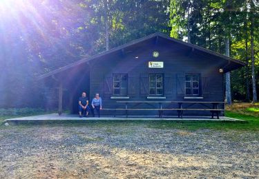
Parking de l'Eglise de Fresse sur Moselle - Tête de Seux - La Noire Goutte - la Croix de Fresse puis Abri de la Croix de Fresse - Abri du Vallon - Tête du Couteau et retour
Localisation
Pays :
France
Région :
Grand Est
Département/Province :
Vosges
Commune :
Fresse-sur-Moselle
Localité :
Unknown
Départ:(Dec)
Départ:(UTM)
334691 ; 5304838 (32T) N.
Commentaires
Randonnées à proximité
![Randonnée Marche Le Ménil - Boucle au départ des chalets de la](https://media.geolcdn.com/t/375/260/a828a9f3-0482-4d5b-86c2-c919e4b59d9f.jpg&format=jpg&maxdim=2)
![Marche Marche](https://static1.geolcdn.com/sitytour/trail-icons/101.png)
Boucle au départ des chalets de la "Vosges Attitude"
Marche
Facile
(3)
Le Ménil,
Grand Est,
Vosges,
France
![](/images/other/stat-length.png)
10 km | 14,1 km-effort
3h 0min
![](https://static1.geolcdn.com/siteimages/upload/files/16400158638029165_repeat_loop_refresh_sync_direction_icon.png)
Oui
![Randonnée Marche Saint-Maurice-sur-Moselle - Tour du Ballon d'Alsace - Photo](https://media.geolcdn.com/t/375/260/ext.jpg?maxdim=2&url=https%3A%2F%2Fservices.sitytrail.com%2FGeolivesWS%2FDownloadMedia.ashx%3FTrailID%3D450011%26Media%3Dfix__20150716161020.jpg)
![Marche Marche](https://static1.geolcdn.com/sitytour/trail-icons/101.png)
Tour du Ballon d'Alsace
Marche
Difficile
(1)
Saint-Maurice-sur-Moselle,
Grand Est,
Vosges,
France
![](/images/other/stat-length.png)
10,5 km | 17,7 km-effort
5h 25min
![](https://static1.geolcdn.com/siteimages/upload/files/16400158638029165_repeat_loop_refresh_sync_direction_icon.png)
Oui
![V.T.T. V.T.T.](https://static1.geolcdn.com/sitytour/trail-icons/202.png)
VTT de la grande Goutte N°13
V.T.T.
Moyen
Saint-Maurice-sur-Moselle,
Grand Est,
Vosges,
France
![](/images/other/stat-length.png)
21 km | 30 km-effort
2h 3min
![](https://static1.geolcdn.com/siteimages/upload/files/16400158638029165_repeat_loop_refresh_sync_direction_icon.png)
Oui
![Randonnée A pied Fresse-sur-Moselle - Les ballons à l’horizon - Photo](https://media.geolcdn.com/t/375/260/30df9189-1183-47e3-a585-be073639a450.jpeg&format=jpg&maxdim=2)
![A pied A pied](https://static1.geolcdn.com/sitytour/trail-icons/100.png)
Les ballons à l’horizon
A pied
Facile
Fresse-sur-Moselle,
Grand Est,
Vosges,
France
![](/images/other/stat-length.png)
7,7 km | 12,6 km-effort
2h 51min
![](https://static1.geolcdn.com/siteimages/upload/files/16400158638029165_repeat_loop_refresh_sync_direction_icon.png)
Oui
![Randonnée V.T.T. Bussang - Vtt de Bussang 2 - Photo](https://media.geolcdn.com/t/375/260/ext.jpg?maxdim=2&url=https%3A%2F%2Fservices.sitytrail.com%2FGeolivesWS%2FDownloadMedia.ashx%3FTrailID%3D482495%26Media%3D3a948384-aaf8-4502-8e08-6315d7b53ee7.jpg)
![V.T.T. V.T.T.](https://static1.geolcdn.com/sitytour/trail-icons/202.png)
![Randonnée Marche Haut-du-Them-Château-Lambert - Chateau-Lambert mines de cuivre et source de l'Oignon - Photo](https://media.geolcdn.com/t/375/260/ext.jpg?maxdim=2&url=https%3A%2F%2Fstatic1.geolcdn.com%2Fsiteimages%2Fupload%2Ffiles%2F1553511878bg_sport_marche.png)
![Marche Marche](https://static1.geolcdn.com/sitytour/trail-icons/101.png)
Chateau-Lambert mines de cuivre et source de l'Oignon
Marche
Facile
(1)
Haut-du-Them-Château-Lambert,
Bourgogne-Franche-Comté,
Haute-Saône,
France
![](/images/other/stat-length.png)
9,6 km | 14,6 km-effort
2h 30min
![](https://static1.geolcdn.com/siteimages/upload/files/16400158638029165_repeat_loop_refresh_sync_direction_icon.png)
Oui
![Randonnée Marche Ramonchamp - Tournée de 3 chalets - Photo](https://media.geolcdn.com/t/375/260/9772d619-fbbf-4858-9b6a-d813a318e1c1.jpeg&format=jpg&maxdim=2)
![Marche Marche](https://static1.geolcdn.com/sitytour/trail-icons/101.png)
Tournée de 3 chalets
Marche
Moyen
Ramonchamp,
Grand Est,
Vosges,
France
![](/images/other/stat-length.png)
6,2 km | 9 km-effort
2h 3min
![](https://static1.geolcdn.com/siteimages/upload/files/16400158638029165_repeat_loop_refresh_sync_direction_icon.png)
Oui
![Randonnée Marche Bussang - TREK ALSACIEN (boucle rochelotte) - Photo](https://media.geolcdn.com/t/375/260/9ec84553-ee04-4a10-aa7e-0d30d0797c90.jpg&format=jpg&maxdim=2)
![Marche Marche](https://static1.geolcdn.com/sitytour/trail-icons/101.png)
TREK ALSACIEN (boucle rochelotte)
Marche
Facile
Bussang,
Grand Est,
Vosges,
France
![](/images/other/stat-length.png)
8,1 km | 11,7 km-effort
2h 39min
![](https://static1.geolcdn.com/siteimages/upload/files/16400158638029165_repeat_loop_refresh_sync_direction_icon.png)
Oui
![Randonnée Marche Saint-Maurice-sur-Moselle - tour ballon d'Alsace - Photo](https://media.geolcdn.com/t/375/260/70cb115f-372e-4393-8af4-1c0050bc6f83.jpg&format=jpg&maxdim=2)
![Marche Marche](https://static1.geolcdn.com/sitytour/trail-icons/101.png)
tour ballon d'Alsace
Marche
Facile
Saint-Maurice-sur-Moselle,
Grand Est,
Vosges,
France
![](/images/other/stat-length.png)
17,2 km | 26 km-effort
4h 36min
![](https://static1.geolcdn.com/siteimages/upload/files/16400158638029165_repeat_loop_refresh_sync_direction_icon.png)
Oui