Randonnée Marche Buhl - 68  Buhl -Lautenbach Zell - Photo

68 Buhl -Lautenbach Zell

 E.BURCK
E.BURCK

Utilisateur

© OpenStreetMap contributors
Longueur
Longueur
10 km
Altitude max
Altitude max
632 m
Dénivelé positif
Dénivelé positif
378 m
Km-Effort
Km-Effort  
15 km
Altitude min
Altitude min
351 m
Dénivelé négatif
Dénivelé négatif
381 m
Boucle
Boucle
Oui
Date de création :
2020-02-17 18:03:24.505
Dernière modification :
2020-02-17 18:05:22.186

(0 Avis)

Marche
Marche
3h07
Difficulté : Difficile

Scannez ce code QR pour ouvrir la randonnée dans l'application SityTrail

Application GPS de randonnée GRATUITE

Logo SityTrail SityTrail

IGN / Instituts géographiques

Télécharger SityTrail sur l'App Store Télécharger SityTrail sur Google Play

Logo SityTrail SityTrail World

Le monde est à vous

Télécharger SityTrail sur l'App Store Télécharger SityTrail sur Google Play Télécharger SityTrail sur Huawei AppGallery

À propos

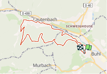
Randonnée Marche de 10 km à découvrir à Grand Est, Haut-Rhin, Buhl. Cette randonnée est proposée par E.BURCK.

Description

Cette semaine, je vous propose d'aller manger le couscous à Lautenbach Zell.
Chemins connus mais parcours inédit. Dénivelé de 380 m et distance totale de 10,0 km dont 6 le matin.

ACCÈS :
- Par Guebwiller => Buhl.
PARKING :
- place de l'Église à Buhl
47°55'39.7"N 7°10'54.5"E
47.9277,          7.1818

RESTAURATION :      
Restaurant à la Truite, Lautenbach-Zell.
Tél: 03 89 74 05 17

Profil altimétrique

Localisation

Pays :
France
Région :
Grand Est
Département/Province :
Haut-Rhin
Commune :
Buhl
Localité :
Unknown
Départ:(UTM)
364182 ; 5309869 (32T) N.

Randonnées à proximité

Randonnée A pied Goldbach-Altenbach - Firstacker - Willer sur Thur - Photo
A pied
GUIDE+

A pied

Facile
Goldbach-Altenbach, Grand Est, Haut-Rhin, France
7,4 km | 9,6 km-effort
2h 11min
Non
Randonnée V.T.T. Guebwiller - P4  Circuits du Florival 2021   - Photo
V.T.T.
duchaine.nicolas

V.T.T.

Moyen
(1)
Guebwiller, Grand Est, Haut-Rhin, France
40 km | 53 km-effort
4h 31min
Non
Randonnée Marche Murbach - Rando du 01/08/2024 - Photo
Marche
boubou68

Marche

Très difficile
Murbach, Grand Est, Haut-Rhin, France
18,9 km | 30 km-effort
5h 53min
Oui
Randonnée Marche Soultz-Haut-Rhin - Rando Marcheurs..04/04_2025 - Photo
Marche
boubou68

Marche

Très difficile
Soultz-Haut-Rhin, Grand Est, Haut-Rhin, France
21 km | 35 km-effort
4h 42min
Oui
Randonnée Marche Murbach - La
Marche
boubou68

Marche

Très difficile
Murbach, Grand Est, Haut-Rhin, France
14,7 km | 28 km-effort
4h 3min
Oui
Randonnée Marche Murbach - Murbach - Photo
Marche
oscar1

Marche

Difficile
Murbach, Grand Est, Haut-Rhin, France
15,4 km | 25 km-effort
4h 25min
Oui
Randonnée Marche Soultzmatt - Rando du 30/03/2034 - Photo
Marche
boubou68

Marche

Difficile
Soultzmatt, Grand Est, Haut-Rhin, France
19,5 km | 29 km-effort
4h 32min
Oui
Randonnée Marche Goldbach-Altenbach - Firstacker - Grand Ballon (11/08/2022) - Photo
Marche
Richard68500

Marche

Moyen
Goldbach-Altenbach, Grand Est, Haut-Rhin, France
14,2 km | 22 km-effort
4h 22min
Oui
Randonnée Marche Linthal - Linthal - Petit Ballon - Klintzkopf - Photo
Marche
Bart2015

Marche

Difficile
Linthal, Grand Est, Haut-Rhin, France
23 km | 37 km-effort
5h 25min
Oui


Fermer
Mes abonnements