![](/images/other/stat-length.png)
![Randonnée Marche Saint-Pardoux-la-Rivière - St-Pardoux-la-Rivière Dorie 13km - Photo](https://media.geolcdn.com/t/1900/400/ext.pjpeg?maxdim=2&url=https%3A%2F%2Fstatic1.geolcdn.com%2Fsiteimages%2Fupload%2Ffiles%2F1553511878bg_sport_marche.png)
St-Pardoux-la-Rivière Dorie 13km
YV24
Utilisateur
![Longueur](/images/other/stat-length.png)
Longueur
12,4 km
![Altitude max](https://static1.geolcdn.com/siteimages/upload/files/1508320355ic_sort_altitude_max_24dp.png)
Altitude max
318 m
![Dénivelé positif](https://static1.geolcdn.com/siteimages/upload/files/1508320355ic_sort_den_pos_24dp.png)
Dénivelé positif
255 m
![Km-Effort](/images/other/stat-length.png)
Km-Effort
15,8 km
![Altitude min](https://static1.geolcdn.com/siteimages/upload/files/1508320355ic_sort_altitude_min_24dp.png)
Altitude min
140 m
![Dénivelé négatif](https://static1.geolcdn.com/siteimages/upload/files/1508320355ic_sort_den_neg_24dp.png)
Dénivelé négatif
255 m
![Boucle](https://static1.geolcdn.com/siteimages/upload/files/16400158638029165_repeat_loop_refresh_sync_direction_icon.png)
Boucle
Oui
Date de création :
2014-12-10 00:00:00.0
Dernière modification :
2014-12-10 00:00:00.0
![Marche](https://static1.geolcdn.com/sitytour/trail-icons/101.png)
3h26
Difficulté : Facile
![Scannez ce code QR pour ouvrir la randonnée dans l'application SityTrail](https://capi.geolives.com/qq0zvz2zws4bq2lad0pu/sitytour/trails/232678/qr.png?size=200)
Application GPS de randonnée GRATUITE
À propos
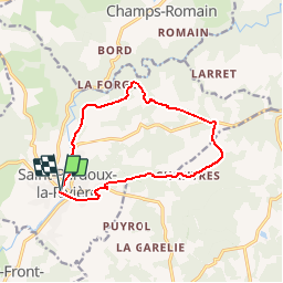
Randonnée Marche de 12,4 km à découvrir à Nouvelle-Aquitaine, Dordogne, Saint-Pardoux-la-Rivière. Cette randonnée est proposée par YV24.
Description
Selon PDIPR boucle de la Dorie.
Attention, tracé balisé pour le sens anti horaire seulement. Pas mal (trop) de bitume. Chemin creux entre Chaumeille et Bon Ombre. Parcours à éviter en période humide et de pluie récente.
Localisation
Pays :
France
Région :
Nouvelle-Aquitaine
Département/Province :
Dordogne
Commune :
Saint-Pardoux-la-Rivière
Localité :
Unknown
Départ:(Dec)
Départ:(UTM)
323789 ; 5040151 (31T) N.
Commentaires
Randonnées à proximité
![Randonnée Marche Milhac-de-Nontron - Milhac de Nontron Chadeuil 12km - Photo](https://media.geolcdn.com/t/375/260/ext.jpg?maxdim=2&url=https%3A%2F%2Fstatic1.geolcdn.com%2Fsiteimages%2Fupload%2Ffiles%2F1553511878bg_sport_marche.png)
![Marche Marche](https://static1.geolcdn.com/sitytour/trail-icons/101.png)
Milhac de Nontron Chadeuil 12km
Marche
Facile
(2)
Milhac-de-Nontron,
Nouvelle-Aquitaine,
Dordogne,
France
![](/images/other/stat-length.png)
11,8 km | 14,8 km-effort
3h 11min
![](https://static1.geolcdn.com/siteimages/upload/files/16400158638029165_repeat_loop_refresh_sync_direction_icon.png)
Oui
![Randonnée Marche Milhac-de-Nontron - Milhac de Nontron La Croze - Photo](https://media.geolcdn.com/t/375/260/f9e11995-171b-4511-931f-13c8866981a3.jpg&format=jpg&maxdim=2)
![Marche Marche](https://static1.geolcdn.com/sitytour/trail-icons/101.png)
Milhac de Nontron La Croze
Marche
Facile
Milhac-de-Nontron,
Nouvelle-Aquitaine,
Dordogne,
France
![](/images/other/stat-length.png)
14,6 km | 18,1 km-effort
3h 32min
![](https://static1.geolcdn.com/siteimages/upload/files/16400158638029165_repeat_loop_refresh_sync_direction_icon.png)
Non
![Randonnée Marche Milhac-de-Nontron - Boucle de Milhac de Nontron à Croze - Photo](https://media.geolcdn.com/t/375/260/0dbe7594-558b-4972-b148-dcc5a924d2f9.jpg&format=jpg&maxdim=2)
![Marche Marche](https://static1.geolcdn.com/sitytour/trail-icons/101.png)
Boucle de Milhac de Nontron à Croze
Marche
Difficile
Milhac-de-Nontron,
Nouvelle-Aquitaine,
Dordogne,
France
![](/images/other/stat-length.png)
14,2 km | 17,8 km-effort
4h 2min
![](https://static1.geolcdn.com/siteimages/upload/files/16400158638029165_repeat_loop_refresh_sync_direction_icon.png)
Oui
![Randonnée A pied Milhac-de-Nontron - Milhac de Nontron Chantres la chapelle - Photo](https://media.geolcdn.com/t/375/260/ext.jpg?maxdim=2&url=https%3A%2F%2Fstatic1.geolcdn.com%2Fsiteimages%2Fupload%2Ffiles%2F1545311037marcheuse_200dpi.jpg)
![A pied A pied](https://static1.geolcdn.com/sitytour/trail-icons/100.png)
Milhac de Nontron Chantres la chapelle
A pied
Difficile
Milhac-de-Nontron,
Nouvelle-Aquitaine,
Dordogne,
France
![](/images/other/stat-length.png)
25 km | 32 km-effort
7h 18min
![](https://static1.geolcdn.com/siteimages/upload/files/16400158638029165_repeat_loop_refresh_sync_direction_icon.png)
Oui
![Randonnée Marche Saint-Front-la-Rivière - tour de la vierge - Photo](https://media.geolcdn.com/t/375/260/ext.jpg?maxdim=2&url=https%3A%2F%2Fstatic1.geolcdn.com%2Fsiteimages%2Fupload%2Ffiles%2F1553511878bg_sport_marche.png)
![Marche Marche](https://static1.geolcdn.com/sitytour/trail-icons/101.png)
tour de la vierge
Marche
Facile
Saint-Front-la-Rivière,
Nouvelle-Aquitaine,
Dordogne,
France
![](/images/other/stat-length.png)
8,9 km | 11,2 km-effort
2h 10min
![](https://static1.geolcdn.com/siteimages/upload/files/16400158638029165_repeat_loop_refresh_sync_direction_icon.png)
Non
![Randonnée Marche Saint-Front-la-Rivière - boucle la renaudie - Photo](https://media.geolcdn.com/t/375/260/ext.jpg?maxdim=2&url=https%3A%2F%2Fstatic1.geolcdn.com%2Fsiteimages%2Fupload%2Ffiles%2F1553511878bg_sport_marche.png)
![Marche Marche](https://static1.geolcdn.com/sitytour/trail-icons/101.png)
boucle la renaudie
Marche
Facile
Saint-Front-la-Rivière,
Nouvelle-Aquitaine,
Dordogne,
France
![](/images/other/stat-length.png)
10,1 km | 12,4 km-effort
2h 18min
![](https://static1.geolcdn.com/siteimages/upload/files/16400158638029165_repeat_loop_refresh_sync_direction_icon.png)
Oui
![Randonnée Marche Champs-Romain - Champs-Romain Tacot 12km - Photo](https://media.geolcdn.com/t/375/260/ext.jpg?maxdim=2&url=https%3A%2F%2Fstatic1.geolcdn.com%2Fsiteimages%2Fupload%2Ffiles%2F1553511878bg_sport_marche.png)
![Marche Marche](https://static1.geolcdn.com/sitytour/trail-icons/101.png)
Champs-Romain Tacot 12km
Marche
Difficile
Champs-Romain,
Nouvelle-Aquitaine,
Dordogne,
France
![](/images/other/stat-length.png)
11,6 km | 14,3 km-effort
3h 6min
![](https://static1.geolcdn.com/siteimages/upload/files/16400158638029165_repeat_loop_refresh_sync_direction_icon.png)
Oui
![Randonnée Marche Champs-Romain - saut du chalard par Larret - Photo](https://media.geolcdn.com/t/375/260/ext.jpg?maxdim=2&url=https%3A%2F%2Fstatic1.geolcdn.com%2Fsiteimages%2Fupload%2Ffiles%2F1553511878bg_sport_marche.png)
![Marche Marche](https://static1.geolcdn.com/sitytour/trail-icons/101.png)
saut du chalard par Larret
Marche
Difficile
Champs-Romain,
Nouvelle-Aquitaine,
Dordogne,
France
![](/images/other/stat-length.png)
9,9 km | 13,5 km-effort
2h 56min
![](https://static1.geolcdn.com/siteimages/upload/files/16400158638029165_repeat_loop_refresh_sync_direction_icon.png)
Oui
![Randonnée Marche Champs-Romain - Saut du Chalard - Photo](https://media.geolcdn.com/t/375/260/ext.jpg?maxdim=2&url=https%3A%2F%2Fstatic1.geolcdn.com%2Fsiteimages%2Fupload%2Ffiles%2F1553511878bg_sport_marche.png)
![Marche Marche](https://static1.geolcdn.com/sitytour/trail-icons/101.png)
Saut du Chalard
Marche
Facile
(2)
Champs-Romain,
Nouvelle-Aquitaine,
Dordogne,
France
![](/images/other/stat-length.png)
2,3 km | 3,4 km-effort
49min
![](https://static1.geolcdn.com/siteimages/upload/files/16400158638029165_repeat_loop_refresh_sync_direction_icon.png)
Oui