![](/images/other/stat-length.png)
![Randonnée Marche Brantôme en Périgord - Puy-de-Fourche 12,5km - Photo](https://media.geolcdn.com/t/1900/400/ext.pjpeg?maxdim=2&url=https%3A%2F%2Fstatic1.geolcdn.com%2Fsiteimages%2Fupload%2Ffiles%2F1553511878bg_sport_marche.png)
Puy-de-Fourche 12,5km
YV24
Utilisateur
![Longueur](/images/other/stat-length.png)
Longueur
12,6 km
![Altitude max](https://static1.geolcdn.com/siteimages/upload/files/1508320355ic_sort_altitude_max_24dp.png)
Altitude max
239 m
![Dénivelé positif](https://static1.geolcdn.com/siteimages/upload/files/1508320355ic_sort_den_pos_24dp.png)
Dénivelé positif
219 m
![Km-Effort](/images/other/stat-length.png)
Km-Effort
15,5 km
![Altitude min](https://static1.geolcdn.com/siteimages/upload/files/1508320355ic_sort_altitude_min_24dp.png)
Altitude min
124 m
![Dénivelé négatif](https://static1.geolcdn.com/siteimages/upload/files/1508320355ic_sort_den_neg_24dp.png)
Dénivelé négatif
220 m
![Boucle](https://static1.geolcdn.com/siteimages/upload/files/16400158638029165_repeat_loop_refresh_sync_direction_icon.png)
Boucle
Oui
Date de création :
2017-03-14 00:00:00.0
Dernière modification :
2017-03-14 00:00:00.0
![Marche](https://static1.geolcdn.com/sitytour/trail-icons/101.png)
3h19
Difficulté : Facile
![Scannez ce code QR pour ouvrir la randonnée dans l'application SityTrail](https://capi.geolives.com/qq0zvz2zws4bq2lad0pu/sitytour/trails/232663/qr.png?size=200)
Application GPS de randonnée GRATUITE
À propos
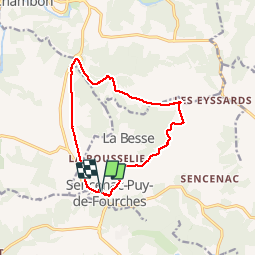
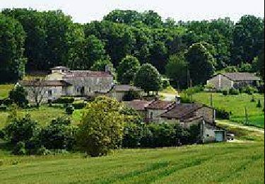
Randonnée Marche de 12,6 km à découvrir à Nouvelle-Aquitaine, Dordogne, Brantôme en Périgord. Cette randonnée est proposée par YV24.
Description
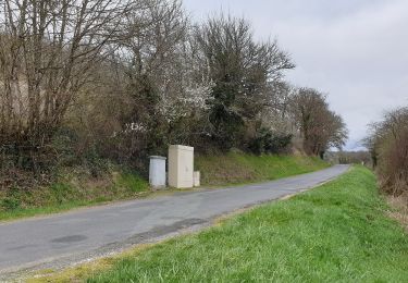
Selon PDIPR, au départ de Puy de Fourche. Circuit varié,peu de route, bien balisé, praticable en tout temps.
Localisation
Pays :
France
Région :
Nouvelle-Aquitaine
Département/Province :
Dordogne
Commune :
Brantôme en Périgord
Localité :
Sencenac-Puy-de-Fourches
Départ:(Dec)
Départ:(UTM)
316624 ; 5019764 (31T) N.
Commentaires
Randonnées à proximité
![Randonnée Marche Brantôme en Périgord - Valeuil sAINT julien Bourdeilles court 15 km - Photo](https://media.geolcdn.com/t/375/260/ext.jpg?maxdim=2&url=https%3A%2F%2Fstatic1.geolcdn.com%2Fsiteimages%2Fupload%2Ffiles%2F1553511878bg_sport_marche.png)
![Marche Marche](https://static1.geolcdn.com/sitytour/trail-icons/101.png)
Valeuil sAINT julien Bourdeilles court 15 km
Marche
Facile
(1)
Brantôme en Périgord,
Nouvelle-Aquitaine,
Dordogne,
France
![](/images/other/stat-length.png)
15,1 km | 18,3 km-effort
3h 20min
![](https://static1.geolcdn.com/siteimages/upload/files/16400158638029165_repeat_loop_refresh_sync_direction_icon.png)
Oui
![Randonnée Marche Brantôme en Périgord - Valeuil Bourdeilles court 13km - Photo](https://media.geolcdn.com/t/375/260/ext.jpg?maxdim=2&url=https%3A%2F%2Fstatic1.geolcdn.com%2Fsiteimages%2Fupload%2Ffiles%2F1553511878bg_sport_marche.png)
![Marche Marche](https://static1.geolcdn.com/sitytour/trail-icons/101.png)
Valeuil Bourdeilles court 13km
Marche
Facile
(2)
Brantôme en Périgord,
Nouvelle-Aquitaine,
Dordogne,
France
![](/images/other/stat-length.png)
12,6 km | 15,6 km-effort
3h 26min
![](https://static1.geolcdn.com/siteimages/upload/files/16400158638029165_repeat_loop_refresh_sync_direction_icon.png)
Oui
![Randonnée A pied Bussac - Boucle de Bussac - Photo](https://media.geolcdn.com/t/375/260/5fccc024-9483-4e9e-aafa-fb24ea2402de.jpeg&format=jpg&maxdim=2)
![A pied A pied](https://static1.geolcdn.com/sitytour/trail-icons/100.png)
Boucle de Bussac
A pied
Facile
Bussac,
Nouvelle-Aquitaine,
Dordogne,
France
![](/images/other/stat-length.png)
3,7 km | 4,8 km-effort
1h 5min
![](https://static1.geolcdn.com/siteimages/upload/files/16400158638029165_repeat_loop_refresh_sync_direction_icon.png)
Oui
![Randonnée Marche nordique Agonac - La porte Laborie 13 km - Photo](https://media.geolcdn.com/t/375/260/ext.jpg?maxdim=2&url=https%3A%2F%2Fstatic1.geolcdn.com%2Fsiteimages%2Fupload%2Ffiles%2F1545311037marcheuse_200dpi.jpg)
![Marche nordique Marche nordique](https://static1.geolcdn.com/sitytour/trail-icons/102.png)
La porte Laborie 13 km
Marche nordique
Facile
(1)
Agonac,
Nouvelle-Aquitaine,
Dordogne,
France
![](/images/other/stat-length.png)
13,4 km | 16,3 km-effort
2h 10min
![](https://static1.geolcdn.com/siteimages/upload/files/16400158638029165_repeat_loop_refresh_sync_direction_icon.png)
Oui
![Randonnée Marche nordique Brantôme en Périgord - Puy de Fourches MN - Photo](https://media.geolcdn.com/t/375/260/b2e6b5db-70e9-4e82-9957-ec4047ed90be.jpg&format=jpg&maxdim=2)
![Marche nordique Marche nordique](https://static1.geolcdn.com/sitytour/trail-icons/102.png)
Puy de Fourches MN
Marche nordique
Très facile
Brantôme en Périgord,
Nouvelle-Aquitaine,
Dordogne,
France
![](/images/other/stat-length.png)
9,6 km | 12,6 km-effort
Inconnu
![](https://static1.geolcdn.com/siteimages/upload/files/16400158638029165_repeat_loop_refresh_sync_direction_icon.png)
Oui
![Randonnée Marche Brantôme en Périgord - Boucle de Puy de Fourches - Photo](https://media.geolcdn.com/t/375/260/9040ea6a-96c4-4be4-a516-67e0f8dd1119.jpg&format=jpg&maxdim=2)
![Marche Marche](https://static1.geolcdn.com/sitytour/trail-icons/101.png)
Boucle de Puy de Fourches
Marche
Difficile
(3)
Brantôme en Périgord,
Nouvelle-Aquitaine,
Dordogne,
France
![](/images/other/stat-length.png)
12,2 km | 15,1 km-effort
3h 25min
![](https://static1.geolcdn.com/siteimages/upload/files/16400158638029165_repeat_loop_refresh_sync_direction_icon.png)
Oui
![Randonnée Vélo de route Agonac - 10km autour de la porte 56 km - Photo](https://media.geolcdn.com/t/375/260/ext.jpg?maxdim=2&url=https%3A%2F%2Fstatic1.geolcdn.com%2Fsiteimages%2Fupload%2Ffiles%2F1524743154velo.jpg)
![Vélo de route Vélo de route](https://static1.geolcdn.com/sitytour/trail-icons/201.png)
10km autour de la porte 56 km
Vélo de route
Moyen
Agonac,
Nouvelle-Aquitaine,
Dordogne,
France
![](/images/other/stat-length.png)
56 km | 66 km-effort
2h 30min
![](https://static1.geolcdn.com/siteimages/upload/files/16400158638029165_repeat_loop_refresh_sync_direction_icon.png)
Oui
![Randonnée Marche Brantôme en Périgord - Valeuil boucle de Valeuil 12km - Photo](https://media.geolcdn.com/t/375/260/ext.jpg?maxdim=2&url=https%3A%2F%2Fstatic1.geolcdn.com%2Fsiteimages%2Fupload%2Ffiles%2F1553511878bg_sport_marche.png)
![Marche Marche](https://static1.geolcdn.com/sitytour/trail-icons/101.png)
Valeuil boucle de Valeuil 12km
Marche
Facile
Brantôme en Périgord,
Nouvelle-Aquitaine,
Dordogne,
France
![](/images/other/stat-length.png)
12 km | 15,4 km-effort
2h 57min
![](https://static1.geolcdn.com/siteimages/upload/files/16400158638029165_repeat_loop_refresh_sync_direction_icon.png)
Oui
![Randonnée Marche Biras - boucle biras - Photo](https://media.geolcdn.com/t/375/260/ext.jpg?maxdim=2&url=https%3A%2F%2Fstatic1.geolcdn.com%2Fsiteimages%2Fupload%2Ffiles%2F1553511878bg_sport_marche.png)
![Marche Marche](https://static1.geolcdn.com/sitytour/trail-icons/101.png)
boucle biras
Marche
Très facile
(1)
Biras,
Nouvelle-Aquitaine,
Dordogne,
France
![](/images/other/stat-length.png)
9,9 km | 13 km-effort
2h 52min
![](https://static1.geolcdn.com/siteimages/upload/files/16400158638029165_repeat_loop_refresh_sync_direction_icon.png)
Oui