![](/images/other/stat-length.png)
![Randonnée Marche Jumilhac-le-Grand - Jumilhac le Grand Moulins 14km - Photo](https://media.geolcdn.com/t/1900/400/ext.pjpeg?maxdim=2&url=https%3A%2F%2Fstatic1.geolcdn.com%2Fsiteimages%2Fupload%2Ffiles%2F1553511878bg_sport_marche.png)
Jumilhac le Grand Moulins 14km
YV24
Utilisateur
![Longueur](/images/other/stat-length.png)
Longueur
13,7 km
![Altitude max](https://static1.geolcdn.com/siteimages/upload/files/1508320355ic_sort_altitude_max_24dp.png)
Altitude max
344 m
![Dénivelé positif](https://static1.geolcdn.com/siteimages/upload/files/1508320355ic_sort_den_pos_24dp.png)
Dénivelé positif
375 m
![Km-Effort](/images/other/stat-length.png)
Km-Effort
18,7 km
![Altitude min](https://static1.geolcdn.com/siteimages/upload/files/1508320355ic_sort_altitude_min_24dp.png)
Altitude min
215 m
![Dénivelé négatif](https://static1.geolcdn.com/siteimages/upload/files/1508320355ic_sort_den_neg_24dp.png)
Dénivelé négatif
375 m
![Boucle](https://static1.geolcdn.com/siteimages/upload/files/16400158638029165_repeat_loop_refresh_sync_direction_icon.png)
Boucle
Oui
Date de création :
2015-01-15 00:00:00.0
Dernière modification :
2019-06-19 14:27:01.098
![Marche](https://static1.geolcdn.com/sitytour/trail-icons/101.png)
4h04
Difficulté : Facile
![Scannez ce code QR pour ouvrir la randonnée dans l'application SityTrail](https://capi.geolives.com/qq0zvz2zws4bq2lad0pu/sitytour/trails/232640/qr.png?size=200)
Application GPS de randonnée GRATUITE
À propos
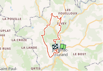
Randonnée Marche de 13,7 km à découvrir à Nouvelle-Aquitaine, Dordogne, Jumilhac-le-Grand. Cette randonnée est proposée par YV24.
Description
Selon PDIPR de la boucle des Moulins.
Tracé agréable, assez varié.
Départ depuis le parking devant le château.
Pique-nique possible au bord de l'Isle
Localisation
Pays :
France
Région :
Nouvelle-Aquitaine
Département/Province :
Dordogne
Commune :
Jumilhac-le-Grand
Localité :
Unknown
Départ:(Dec)
Départ:(UTM)
348463 ; 5039546 (31T) N.
Commentaires
Randonnées à proximité
![Randonnée Marche Jumilhac-le-Grand - Jumilhac-le-Grand Moulins courte 12km - Photo](https://media.geolcdn.com/t/375/260/ext.jpg?maxdim=2&url=https%3A%2F%2Fstatic1.geolcdn.com%2Fsiteimages%2Fupload%2Ffiles%2F1553511878bg_sport_marche.png)
![Marche Marche](https://static1.geolcdn.com/sitytour/trail-icons/101.png)
Jumilhac-le-Grand Moulins courte 12km
Marche
Facile
(3)
Jumilhac-le-Grand,
Nouvelle-Aquitaine,
Dordogne,
France
![](/images/other/stat-length.png)
11,8 km | 16,1 km-effort
4h 4min
![](https://static1.geolcdn.com/siteimages/upload/files/16400158638029165_repeat_loop_refresh_sync_direction_icon.png)
Oui
![Randonnée Marche Saint-Paul-la-Roche - saint Paul de roche - Photo](https://media.geolcdn.com/t/375/260/ext.jpg?maxdim=2&url=https%3A%2F%2Fstatic1.geolcdn.com%2Fsiteimages%2Fupload%2Ffiles%2F1553511878bg_sport_marche.png)
![Marche Marche](https://static1.geolcdn.com/sitytour/trail-icons/101.png)
saint Paul de roche
Marche
Facile
(2)
Saint-Paul-la-Roche,
Nouvelle-Aquitaine,
Dordogne,
France
![](/images/other/stat-length.png)
11,6 km | 14,4 km-effort
3h 12min
![](https://static1.geolcdn.com/siteimages/upload/files/16400158638029165_repeat_loop_refresh_sync_direction_icon.png)
Oui
![Randonnée Marche Jumilhac-le-Grand - Jj - Photo](https://media.geolcdn.com/t/375/260/ext.jpg?maxdim=2&url=https%3A%2F%2Fstatic1.geolcdn.com%2Fsiteimages%2Fupload%2Ffiles%2F1553511878bg_sport_marche.png)
![Marche Marche](https://static1.geolcdn.com/sitytour/trail-icons/101.png)
Jj
Marche
Moyen
(1)
Jumilhac-le-Grand,
Nouvelle-Aquitaine,
Dordogne,
France
![](/images/other/stat-length.png)
6,1 km | 8,3 km-effort
2h 10min
![](https://static1.geolcdn.com/siteimages/upload/files/16400158638029165_repeat_loop_refresh_sync_direction_icon.png)
Oui
![Randonnée Marche Saint-Paul-la-Roche - St Paul-la-Roche Cupule 12km - Photo](https://media.geolcdn.com/t/375/260/ext.jpg?maxdim=2&url=https%3A%2F%2Fstatic1.geolcdn.com%2Fsiteimages%2Fupload%2Ffiles%2F1553511878bg_sport_marche.png)
![Marche Marche](https://static1.geolcdn.com/sitytour/trail-icons/101.png)
St Paul-la-Roche Cupule 12km
Marche
Facile
Saint-Paul-la-Roche,
Nouvelle-Aquitaine,
Dordogne,
France
![](/images/other/stat-length.png)
11,3 km | 14 km-effort
3h 6min
![](https://static1.geolcdn.com/siteimages/upload/files/16400158638029165_repeat_loop_refresh_sync_direction_icon.png)
Oui
![Randonnée Randonnée équestre Jumilhac-le-Grand - ballade jumilhac / sarlande - Photo](https://media.geolcdn.com/t/375/260/ext.jpg?maxdim=2&url=https%3A%2F%2Fstatic1.geolcdn.com%2Fsiteimages%2Fupload%2Ffiles%2F1524743154cheval.jpg)
![Randonnée équestre Randonnée équestre](https://static1.geolcdn.com/sitytour/trail-icons/301.png)
ballade jumilhac / sarlande
Randonnée équestre
Moyen
Jumilhac-le-Grand,
Nouvelle-Aquitaine,
Dordogne,
France
![](/images/other/stat-length.png)
16,9 km | 20 km-effort
37min
![](https://static1.geolcdn.com/siteimages/upload/files/16400158638029165_repeat_loop_refresh_sync_direction_icon.png)
Non
![Randonnée Attelage Jumilhac-le-Grand - marcel / le Chalard - Photo](https://media.geolcdn.com/t/375/260/ext.jpg?maxdim=2&url=https%3A%2F%2Fstatic1.geolcdn.com%2Fsiteimages%2Fupload%2Ffiles%2F1524743154cheval.jpg)
![Attelage Attelage](https://static1.geolcdn.com/sitytour/trail-icons/302.png)
marcel / le Chalard
Attelage
Très facile
Jumilhac-le-Grand,
Nouvelle-Aquitaine,
Dordogne,
France
![](/images/other/stat-length.png)
22 km | 30 km-effort
3h 46min
![](https://static1.geolcdn.com/siteimages/upload/files/16400158638029165_repeat_loop_refresh_sync_direction_icon.png)
Non
![Randonnée V.T.T. Jumilhac-le-Grand - rando de jumilhac - Photo](https://media.geolcdn.com/t/375/260/ext.jpg?maxdim=2&url=https%3A%2F%2Fstatic1.geolcdn.com%2Fsiteimages%2Fupload%2Ffiles%2F1524743154velo.jpg)
![V.T.T. V.T.T.](https://static1.geolcdn.com/sitytour/trail-icons/202.png)
rando de jumilhac
V.T.T.
Difficile
Jumilhac-le-Grand,
Nouvelle-Aquitaine,
Dordogne,
France
![](/images/other/stat-length.png)
51 km | 65 km-effort
4h 29min
![](https://static1.geolcdn.com/siteimages/upload/files/16400158638029165_repeat_loop_refresh_sync_direction_icon.png)
Non
![Randonnée Marche Saint-Paul-la-Roche - track - Photo](https://media.geolcdn.com/t/375/260/ext.jpg?maxdim=2&url=https%3A%2F%2Fstatic1.geolcdn.com%2Fsiteimages%2Fupload%2Ffiles%2F1553511878bg_sport_marche.png)
![Marche Marche](https://static1.geolcdn.com/sitytour/trail-icons/101.png)
track
Marche
Facile
Saint-Paul-la-Roche,
Nouvelle-Aquitaine,
Dordogne,
France
![](/images/other/stat-length.png)
11,8 km | 14,6 km-effort
3h 0min
![](https://static1.geolcdn.com/siteimages/upload/files/16400158638029165_repeat_loop_refresh_sync_direction_icon.png)
Oui