![](/images/other/stat-length.png)
![Randonnée Marche Saint-Vallier-de-Thiey - Colle du Maçon,Le Doublier, Castellaras de la Malle du Col du Ferrier - Photo](https://media.geolcdn.com/t/1900/400/ff31b109-1063-4869-b22e-d1a65bff7ef6.jpg&format=pjpeg&maxdim=2)
Colle du Maçon,Le Doublier, Castellaras de la Malle du Col du Ferrier
domi06
Utilisateur
![Longueur](/images/other/stat-length.png)
![Altitude max](https://static1.geolcdn.com/siteimages/upload/files/1508320355ic_sort_altitude_max_24dp.png)
![Dénivelé positif](https://static1.geolcdn.com/siteimages/upload/files/1508320355ic_sort_den_pos_24dp.png)
![Km-Effort](/images/other/stat-length.png)
![Altitude min](https://static1.geolcdn.com/siteimages/upload/files/1508320355ic_sort_altitude_min_24dp.png)
![Dénivelé négatif](https://static1.geolcdn.com/siteimages/upload/files/1508320355ic_sort_den_neg_24dp.png)
![Boucle](https://static1.geolcdn.com/siteimages/upload/files/16400158638029165_repeat_loop_refresh_sync_direction_icon.png)
![Marche](https://static1.geolcdn.com/sitytour/trail-icons/101.png)
5h20
Difficulté : Moyen
![Scannez ce code QR pour ouvrir la randonnée dans l'application SityTrail](https://capi.geolives.com/qq0zvz2zws4bq2lad0pu/sitytour/trails/2324870/qr.png?size=200)
Application GPS de randonnée GRATUITE
À propos
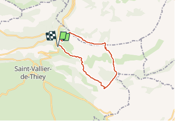
Randonnée Marche de 12 km à découvrir à Provence-Alpes-Côte d'Azur, Alpes-Maritimes, Saint-Vallier-de-Thiey. Cette randonnée est proposée par domi06.
Description
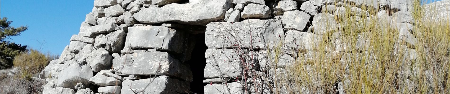
Départ du col du Ferrier par une piste puis une sente caïrnée vers les crêtes de la Colle du Maçon. Rejoindre le col du Clapier ou de la Femme Morte. Belle Borie. Rejoindre le GR4 direction le Doublier par la montée du gazoduc. Prendre la route qui mène au "Centre Radioélectrique du Doublier". Puis sentier caïrné vers le Castellaras de la Malle et retour au col du Ferrier. Belles bories sur le chemin.
Localisation
Commentaires
Randonnées à proximité
![Randonnée Marche Grasse - petit rando au dessus de Grasse - Photo](https://media.geolcdn.com/t/375/260/ext.jpg?maxdim=2&url=https%3A%2F%2Fservices.sitytrail.com%2FGeolivesWS%2FDownloadMedia.ashx%3FTrailID%3D219692%26Media%3Dfix__20130907100916.jpg)
![Marche Marche](https://static1.geolcdn.com/sitytour/trail-icons/101.png)
Marche
![](/images/other/stat-length.png)
![](https://static1.geolcdn.com/siteimages/upload/files/16400158638029165_repeat_loop_refresh_sync_direction_icon.png)
![Randonnée Marche Caussols - Le Haut Montet 1335m, Plateau de Caussols - Photo](https://media.geolcdn.com/t/375/260/ext.jpg?maxdim=2&url=https%3A%2F%2Fservices.sitytrail.com%2FGeolivesWS%2FDownloadMedia.ashx%3FTrailID%3D214865%26Media%3D15407_1.jpg)
![Marche Marche](https://static1.geolcdn.com/sitytour/trail-icons/101.png)
Marche
![](/images/other/stat-length.png)
![](https://static1.geolcdn.com/siteimages/upload/files/16400158638029165_repeat_loop_refresh_sync_direction_icon.png)
![Randonnée Marche Andon - Canaux Audibergue Montagne de Thiey depuis Canaux trace réelle - Photo](https://media.geolcdn.com/t/375/260/051e1c19-173e-486c-8510-4484d711db7f.jpg&format=jpg&maxdim=2)
![Marche Marche](https://static1.geolcdn.com/sitytour/trail-icons/101.png)
Marche
![](/images/other/stat-length.png)
![](https://static1.geolcdn.com/siteimages/upload/files/16400158638029165_repeat_loop_refresh_sync_direction_icon.png)
![Randonnée Marche Saint-Vallier-de-Thiey - Arche de Ponadieu Source de la Pare Baou Mourine Vieux Pont - Photo](https://media.geolcdn.com/t/375/260/7bf7c645-d759-4e3b-9f63-302e7218f005.jpg&format=jpg&maxdim=2)
![Marche Marche](https://static1.geolcdn.com/sitytour/trail-icons/101.png)
Marche
![](/images/other/stat-length.png)
![](https://static1.geolcdn.com/siteimages/upload/files/16400158638029165_repeat_loop_refresh_sync_direction_icon.png)
![Randonnée Marche Saint-Vallier-de-Thiey - St Vallier de Thiey - Aqueduc de Belletrud - Arche de Ponadieu - Photo](https://media.geolcdn.com/t/375/260/102f751b-e867-453b-847f-fc313f16fe9f.jpg&format=jpg&maxdim=2)
![Marche Marche](https://static1.geolcdn.com/sitytour/trail-icons/101.png)
Marche
![](/images/other/stat-length.png)
![](https://static1.geolcdn.com/siteimages/upload/files/16400158638029165_repeat_loop_refresh_sync_direction_icon.png)
![Randonnée Marche Saint-Vallier-de-Thiey - canau - Photo](https://media.geolcdn.com/t/375/260/ca899ab5-eb13-42e5-a84d-3c58455096f9.jpg&format=jpg&maxdim=2)
![Marche Marche](https://static1.geolcdn.com/sitytour/trail-icons/101.png)
Marche
![](/images/other/stat-length.png)
![](https://static1.geolcdn.com/siteimages/upload/files/16400158638029165_repeat_loop_refresh_sync_direction_icon.png)
![Randonnée A pied Caussols - Plateau de Caussols - Photo](https://media.geolcdn.com/t/375/260/598f9742-6bcf-489a-8a9a-6409dd2e2888.jpeg&format=jpg&maxdim=2)
![A pied A pied](https://static1.geolcdn.com/sitytour/trail-icons/100.png)
A pied
![](/images/other/stat-length.png)
![](https://static1.geolcdn.com/siteimages/upload/files/16400158638029165_repeat_loop_refresh_sync_direction_icon.png)
![Randonnée A pied Grasse - Tour de la Marbrière - Photo](https://media.geolcdn.com/t/375/260/75605552-a463-425d-8862-67e7b2a12a52.jpeg&format=jpg&maxdim=2)
![A pied A pied](https://static1.geolcdn.com/sitytour/trail-icons/100.png)
A pied
![](/images/other/stat-length.png)
![](https://static1.geolcdn.com/siteimages/upload/files/16400158638029165_repeat_loop_refresh_sync_direction_icon.png)
![Randonnée V.T.T. Grasse - Boucle au départ d'Altitude 500 vers Gourdon - Photo](https://media.geolcdn.com/t/375/260/ext.jpg?maxdim=2&url=https%3A%2F%2Fstatic1.geolcdn.com%2Fsiteimages%2Fupload%2Ffiles%2F1524743154velo.jpg)
![V.T.T. V.T.T.](https://static1.geolcdn.com/sitytour/trail-icons/202.png)
V.T.T.
![](/images/other/stat-length.png)
![](https://static1.geolcdn.com/siteimages/upload/files/16400158638029165_repeat_loop_refresh_sync_direction_icon.png)