![](/images/other/stat-length.png)
![Randonnée Marche Belœil - Forêt de Stambruge - Photo](https://media.geolcdn.com/t/1900/400/275d503e-8a58-4d68-a695-8b3cf0f06da5.jpg&format=pjpeg&maxdim=2)
Forêt de Stambruge
rfnet
Utilisateur
![Longueur](/images/other/stat-length.png)
Longueur
8,5 km
![Altitude max](https://static1.geolcdn.com/siteimages/upload/files/1508320355ic_sort_altitude_max_24dp.png)
Altitude max
99 m
![Dénivelé positif](https://static1.geolcdn.com/siteimages/upload/files/1508320355ic_sort_den_pos_24dp.png)
Dénivelé positif
85 m
![Km-Effort](/images/other/stat-length.png)
Km-Effort
9,6 km
![Altitude min](https://static1.geolcdn.com/siteimages/upload/files/1508320355ic_sort_altitude_min_24dp.png)
Altitude min
58 m
![Dénivelé négatif](https://static1.geolcdn.com/siteimages/upload/files/1508320355ic_sort_den_neg_24dp.png)
Dénivelé négatif
85 m
![Boucle](https://static1.geolcdn.com/siteimages/upload/files/16400158638029165_repeat_loop_refresh_sync_direction_icon.png)
Boucle
Oui
Date de création :
2020-02-01 13:52:37.736
Dernière modification :
2020-02-01 17:08:54.653
![Marche](https://static1.geolcdn.com/sitytour/trail-icons/101.png)
2h12
Difficulté : Très facile
![Scannez ce code QR pour ouvrir la randonnée dans l'application SityTrail](https://capi.geolives.com/qq0zvz2zws4bq2lad0pu/sitytour/trails/2321274/qr.png?size=200)
Application GPS de randonnée GRATUITE
À propos
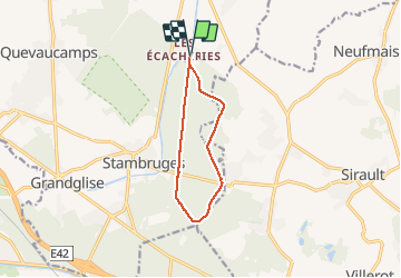
Randonnée Marche de 8,5 km à découvrir à Wallonie, Hainaut, Belœil. Cette randonnée est proposée par rfnet.
Description
Rando en parcours entièrement boisé. Départ des Ecacheries en passant par la Fontaine bouillonnante et entrée de la Mer de sable.
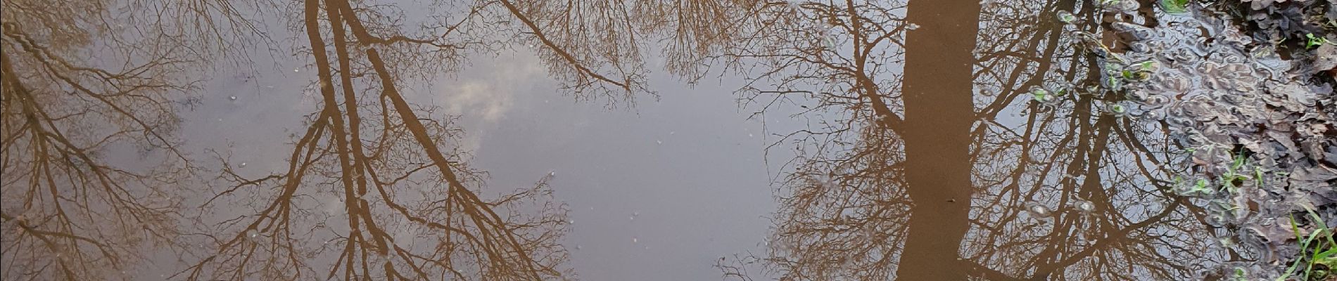
Parcours très gras et parfois glissant par temps très humide.
Localisation
Pays :
Belgique
Région :
Wallonie
Département/Province :
Hainaut
Commune :
Belœil
Localité :
Belil
Départ:(Dec)
Départ:(UTM)
552093 ; 5597753 (31U) N.
Commentaires
Randonnées à proximité
![Randonnée Marche Bernissart - RL-GG-08_Blaton_Erbisoeul - Photo](https://media.geolcdn.com/t/375/260/b5d305e0-4ee4-456e-bfc5-3d0771f79506.jpg&format=jpg&maxdim=2)
![Marche Marche](https://static1.geolcdn.com/sitytour/trail-icons/101.png)
RL-GG-08_Blaton_Erbisoeul
Marche
Très difficile
(2)
Bernissart,
Wallonie,
Hainaut,
Belgique
![](/images/other/stat-length.png)
26 km | 29 km-effort
6h 30min
![](https://static1.geolcdn.com/siteimages/upload/files/16400158638029165_repeat_loop_refresh_sync_direction_icon.png)
Non
![Randonnée Marche Belœil - Chemin de la fontaine bouillante - Photo](https://media.geolcdn.com/t/375/260/ext.jpg?maxdim=2&url=https%3A%2F%2Fservices.sitytrail.com%2FGeolivesWS%2FDownloadMedia.ashx%3FTrailID%3D202870%26Media%3D66f0b4d7-30a6-4305-b894-706a5e0388ba.jpg)
![Marche Marche](https://static1.geolcdn.com/sitytour/trail-icons/101.png)
Chemin de la fontaine bouillante
Marche
Très facile
(3)
Belœil,
Wallonie,
Hainaut,
Belgique
![](/images/other/stat-length.png)
3,6 km | 4,2 km-effort
Inconnu
![](https://static1.geolcdn.com/siteimages/upload/files/16400158638029165_repeat_loop_refresh_sync_direction_icon.png)
Oui
![Randonnée Marche Belœil - Stambruges - Photo](https://media.geolcdn.com/t/375/260/845671f2-de57-446d-a443-835d16757d31.jpg&format=jpg&maxdim=2)
![Marche Marche](https://static1.geolcdn.com/sitytour/trail-icons/101.png)
Stambruges
Marche
Très facile
(1)
Belœil,
Wallonie,
Hainaut,
Belgique
![](/images/other/stat-length.png)
3 km | 3,3 km-effort
38min
![](https://static1.geolcdn.com/siteimages/upload/files/16400158638029165_repeat_loop_refresh_sync_direction_icon.png)
Non
![Randonnée Marche Belœil - Beloeil - Circuit Natura 2000, des sites qui valent le détour - Ht06 - Photo](https://media.geolcdn.com/t/375/260/ext.jpg?maxdim=2&url=https%3A%2F%2Fservices.sitytrail.com%2FGeolivesWS%2FDownloadMedia.ashx%3FTrailID%3D356418%26Media%3D22e60fce-1fd7-4091-9907-7f7360a86d9d.JPG)
![Marche Marche](https://static1.geolcdn.com/sitytour/trail-icons/101.png)
Beloeil - Circuit Natura 2000, des sites qui valent le détour - Ht06
Marche
Très facile
(4)
Belœil,
Wallonie,
Hainaut,
Belgique
![](/images/other/stat-length.png)
3,5 km | 4 km-effort
51min
![](https://static1.geolcdn.com/siteimages/upload/files/16400158638029165_repeat_loop_refresh_sync_direction_icon.png)
Oui
![Randonnée Marche nordique Belœil - Mielikki marche nordique - Stambruges - Voeux 2024 - Photo](https://media.geolcdn.com/t/375/260/ext.jpg?maxdim=2&url=https%3A%2F%2Fstatic1.geolcdn.com%2Fsiteimages%2Fupload%2Ffiles%2F1545311037marcheuse_200dpi.jpg)
![Marche nordique Marche nordique](https://static1.geolcdn.com/sitytour/trail-icons/102.png)
Mielikki marche nordique - Stambruges - Voeux 2024
Marche nordique
Moyen
(1)
Belœil,
Wallonie,
Hainaut,
Belgique
![](/images/other/stat-length.png)
7,5 km | 8,3 km-effort
1h 45min
![](https://static1.geolcdn.com/siteimages/upload/files/16400158638029165_repeat_loop_refresh_sync_direction_icon.png)
Oui
![Randonnée Cheval Belœil - Boucle de Beloeil - Photo](https://media.geolcdn.com/t/375/260/ext.jpg?maxdim=2&url=https%3A%2F%2Fpivotmedia.tourismewallonie.be%2FANX-02-020D-00H9%2FANX-02-020D-00H9.jpg)
![Cheval Cheval](https://static1.geolcdn.com/sitytour/trail-icons/300.png)
Boucle de Beloeil
Cheval
Très facile
Belœil,
Wallonie,
Hainaut,
Belgique
![](/images/other/stat-length.png)
26 km | 30 km-effort
Inconnu
![](https://static1.geolcdn.com/siteimages/upload/files/16400158638029165_repeat_loop_refresh_sync_direction_icon.png)
Non
![Randonnée A pied Chièvres - La ronde des piedsentes - Photo](https://media.geolcdn.com/t/375/260/ext.jpg?maxdim=2&url=https%3A%2F%2Fpivotmedia.tourismewallonie.be%2FANX-02-03X8-001T%2FANX-02-03X8-001T.JPG)
![A pied A pied](https://static1.geolcdn.com/sitytour/trail-icons/100.png)
La ronde des piedsentes
A pied
Facile
Chièvres,
Wallonie,
Hainaut,
Belgique
![](/images/other/stat-length.png)
7,3 km | 7,8 km-effort
1h 46min
![](https://static1.geolcdn.com/siteimages/upload/files/16400158638029165_repeat_loop_refresh_sync_direction_icon.png)
Oui
![Randonnée A pied Belœil - Circuit de la Fontaine bouillante - Photo](https://media.geolcdn.com/t/375/260/ext.jpg?maxdim=2&url=https%3A%2F%2Fpivotmedia.tourismewallonie.be%2FANX-02-03MT-01JO%2FANX-02-03MT-01JO.JPG)
![A pied A pied](https://static1.geolcdn.com/sitytour/trail-icons/100.png)
Circuit de la Fontaine bouillante
A pied
Facile
Belœil,
Wallonie,
Hainaut,
Belgique
![](/images/other/stat-length.png)
3,8 km | 4,5 km-effort
1h 0min
![](https://static1.geolcdn.com/siteimages/upload/files/16400158638029165_repeat_loop_refresh_sync_direction_icon.png)
Oui
![Randonnée A pied Belœil - Circuit de l'Arbre à clous - Photo](https://media.geolcdn.com/t/375/260/ext.jpg?maxdim=2&url=https%3A%2F%2Fpivotmedia.tourismewallonie.be%2FANX-02-03MT-01U2%2FANX-02-03MT-01U2.JPG)
![A pied A pied](https://static1.geolcdn.com/sitytour/trail-icons/100.png)
Circuit de l'Arbre à clous
A pied
Facile
(1)
Belœil,
Wallonie,
Hainaut,
Belgique
![](/images/other/stat-length.png)
5,1 km | 5,8 km-effort
1h 19min
![](https://static1.geolcdn.com/siteimages/upload/files/16400158638029165_repeat_loop_refresh_sync_direction_icon.png)
Oui
Sentiers très boueux.bottes requises