![](/images/other/stat-length.png)
![Randonnée Marche Aniane - Pont du diable - Eglise Saint-Sylvestre - Lavene (Puéchabon) - Pioch de la Bastide - Photo](https://media.geolcdn.com/t/1900/400/b25c94a5-8e23-4d29-a565-cae4885719cb.jpg&format=pjpeg&maxdim=2)
Pont du diable - Eglise Saint-Sylvestre - Lavene (Puéchabon) - Pioch de la Bastide
PiloudeBamako
Utilisateur
![Longueur](/images/other/stat-length.png)
Longueur
15,9 km
![Altitude max](https://static1.geolcdn.com/siteimages/upload/files/1508320355ic_sort_altitude_max_24dp.png)
Altitude max
332 m
![Dénivelé positif](https://static1.geolcdn.com/siteimages/upload/files/1508320355ic_sort_den_pos_24dp.png)
Dénivelé positif
349 m
![Km-Effort](/images/other/stat-length.png)
Km-Effort
21 km
![Altitude min](https://static1.geolcdn.com/siteimages/upload/files/1508320355ic_sort_altitude_min_24dp.png)
Altitude min
57 m
![Dénivelé négatif](https://static1.geolcdn.com/siteimages/upload/files/1508320355ic_sort_den_neg_24dp.png)
Dénivelé négatif
374 m
![Boucle](https://static1.geolcdn.com/siteimages/upload/files/16400158638029165_repeat_loop_refresh_sync_direction_icon.png)
Boucle
Non
Date de création :
2020-01-30 08:32:00.0
Dernière modification :
2020-02-29 19:27:31.943
![Marche](https://static1.geolcdn.com/sitytour/trail-icons/101.png)
5h54
Difficulté : Difficile
![Scannez ce code QR pour ouvrir la randonnée dans l'application SityTrail](https://capi.geolives.com/qq0zvz2zws4bq2lad0pu/sitytour/trails/2319652/qr.png?size=200)
Application GPS de randonnée GRATUITE
À propos
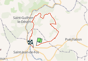
Randonnée Marche de 15,9 km à découvrir à Occitanie, Hérault, Aniane. Cette randonnée est proposée par PiloudeBamako.
Description
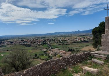
Boucle avec de très belles vues sur le Pont du Diable au retour.
Localisation
Pays :
France
Région :
Occitanie
Département/Province :
Hérault
Commune :
Aniane
Localité :
Unknown
Départ:(Dec)
Départ:(UTM)
545597 ; 4839517 (31T) N.
Commentaires
Randonnées à proximité
![Randonnée Marche Aniane - Aniane ruisseau des Corbières - Photo](https://media.geolcdn.com/t/375/260/ext.jpg?maxdim=2&url=https%3A%2F%2Fservices.sitytrail.com%2FGeolivesWS%2FDownloadMedia.ashx%3FTrailID%3D371677%26Media%3D20141221154017.jpg)
![Marche Marche](https://static1.geolcdn.com/sitytour/trail-icons/101.png)
Aniane ruisseau des Corbières
Marche
Facile
(3)
Aniane,
Occitanie,
Hérault,
France
![](/images/other/stat-length.png)
9,5 km | 12 km-effort
2h 34min
![](https://static1.geolcdn.com/siteimages/upload/files/16400158638029165_repeat_loop_refresh_sync_direction_icon.png)
Oui
![Randonnée Marche Saint-Jean-de-Fos - St Jean de fos Les Plos - Photo](https://media.geolcdn.com/t/375/260/ext.jpg?maxdim=2&url=https%3A%2F%2Fservices.sitytrail.com%2FGeolivesWS%2FDownloadMedia.ashx%3FTrailID%3D358380%26Media%3D20141024141711.jpg)
![Marche Marche](https://static1.geolcdn.com/sitytour/trail-icons/101.png)
St Jean de fos Les Plos
Marche
Facile
(3)
Saint-Jean-de-Fos,
Occitanie,
Hérault,
France
![](/images/other/stat-length.png)
11 km | 15,2 km-effort
3h 5min
![](https://static1.geolcdn.com/siteimages/upload/files/16400158638029165_repeat_loop_refresh_sync_direction_icon.png)
Oui
![Randonnée Marche Montpeyroux - château de castelas - Photo](https://media.geolcdn.com/t/375/260/ext.jpg?maxdim=2&url=https%3A%2F%2Fservices.sitytrail.com%2FGeolivesWS%2FDownloadMedia.ashx%3FTrailID%3D221327%26Media%3D20130914120534.jpg)
![Marche Marche](https://static1.geolcdn.com/sitytour/trail-icons/101.png)
château de castelas
Marche
Facile
(3)
Montpeyroux,
Occitanie,
Hérault,
France
![](/images/other/stat-length.png)
10,3 km | 15,1 km-effort
3h 12min
![](https://static1.geolcdn.com/siteimages/upload/files/16400158638029165_repeat_loop_refresh_sync_direction_icon.png)
Oui
![Randonnée Marche Saint-Guilhem-le-Désert - Herault - St-Guilhem-le-Desert le Roc de la Vigne depuis le barrage 12km 609m - Photo](https://media.geolcdn.com/t/375/260/ext.jpg?maxdim=2&url=https%3A%2F%2Fstatic1.geolcdn.com%2Fsiteimages%2Fupload%2Ffiles%2F1553511878bg_sport_marche.png)
![Marche Marche](https://static1.geolcdn.com/sitytour/trail-icons/101.png)
Herault - St-Guilhem-le-Desert le Roc de la Vigne depuis le barrage 12km 609m
Marche
Moyen
(1)
Saint-Guilhem-le-Désert,
Occitanie,
Hérault,
France
![](/images/other/stat-length.png)
12,1 km | 21 km-effort
4h 17min
![](https://static1.geolcdn.com/siteimages/upload/files/16400158638029165_repeat_loop_refresh_sync_direction_icon.png)
Oui
![Randonnée Marche Saint-Jean-de-Fos - St Jean de Fos et le Max Nègre - Photo](https://media.geolcdn.com/t/375/260/ext.jpg?maxdim=2&url=https%3A%2F%2Fservices.sitytrail.com%2FGeolivesWS%2FDownloadMedia.ashx%3FTrailID%3D230380%26Media%3Dfix__20131101122921.jpg)
![Marche Marche](https://static1.geolcdn.com/sitytour/trail-icons/101.png)
St Jean de Fos et le Max Nègre
Marche
Moyen
Saint-Jean-de-Fos,
Occitanie,
Hérault,
France
![](/images/other/stat-length.png)
19,1 km | 27 km-effort
5h 42min
![](https://static1.geolcdn.com/siteimages/upload/files/16400158638029165_repeat_loop_refresh_sync_direction_icon.png)
Oui
![Randonnée Marche Puéchabon - Causse Puechabon - Photo](https://media.geolcdn.com/t/375/260/ext.jpg?maxdim=2&url=https%3A%2F%2Fstatic1.geolcdn.com%2Fsiteimages%2Fupload%2Ffiles%2F1553511878bg_sport_marche.png)
![Marche Marche](https://static1.geolcdn.com/sitytour/trail-icons/101.png)
Causse Puechabon
Marche
Très facile
(1)
Puéchabon,
Occitanie,
Hérault,
France
![](/images/other/stat-length.png)
12,8 km | 15,9 km-effort
Inconnu
![](https://static1.geolcdn.com/siteimages/upload/files/16400158638029165_repeat_loop_refresh_sync_direction_icon.png)
Oui
![Randonnée Marche Saint-Guilhem-le-Désert - St Guilhem Le Désert - Mas Aubert - Photo](https://media.geolcdn.com/t/375/260/ext.jpg?maxdim=2&url=https%3A%2F%2Fstatic1.geolcdn.com%2Fsiteimages%2Fupload%2Ffiles%2F1553511878bg_sport_marche.png)
![Marche Marche](https://static1.geolcdn.com/sitytour/trail-icons/101.png)
St Guilhem Le Désert - Mas Aubert
Marche
Difficile
(1)
Saint-Guilhem-le-Désert,
Occitanie,
Hérault,
France
![](/images/other/stat-length.png)
19,7 km | 30 km-effort
6h 30min
![](https://static1.geolcdn.com/siteimages/upload/files/16400158638029165_repeat_loop_refresh_sync_direction_icon.png)
Oui
![Randonnée Marche Aniane - Plateau Montcamès - Photo](https://media.geolcdn.com/t/375/260/b02f8392-ab26-453d-ab12-fab47a60d22f.jpg&format=jpg&maxdim=2)
![Marche Marche](https://static1.geolcdn.com/sitytour/trail-icons/101.png)
Plateau Montcamès
Marche
Très difficile
Aniane,
Occitanie,
Hérault,
France
![](/images/other/stat-length.png)
17,7 km | 23 km-effort
6h 21min
![](https://static1.geolcdn.com/siteimages/upload/files/16400158638029165_repeat_loop_refresh_sync_direction_icon.png)
Oui
![Randonnée Marche Montpeyroux - Le bary Arboras le Castelas - Photo](https://media.geolcdn.com/t/375/260/be1b8dbb-902e-4f34-ac2c-776d8a42a8d8.jpg&format=jpg&maxdim=2)
![Marche Marche](https://static1.geolcdn.com/sitytour/trail-icons/101.png)
Le bary Arboras le Castelas
Marche
Facile
Montpeyroux,
Occitanie,
Hérault,
France
![](/images/other/stat-length.png)
11,8 km | 17,1 km-effort
5h 7min
![](https://static1.geolcdn.com/siteimages/upload/files/16400158638029165_repeat_loop_refresh_sync_direction_icon.png)
Oui