![](/images/other/stat-length.png)
![Randonnée Marche Dilsen-Stokkem - Rondje Stokkem... - Photo](https://media.geolcdn.com/t/1900/400/b7fb4249-d5e9-42f4-8dd4-f8e647bebb5c.jpg&format=pjpeg&maxdim=2)
Rondje Stokkem...
bometdehamer
Utilisateur
![Longueur](/images/other/stat-length.png)
Longueur
15,8 km
![Altitude max](https://static1.geolcdn.com/siteimages/upload/files/1508320355ic_sort_altitude_max_24dp.png)
Altitude max
44 m
![Dénivelé positif](https://static1.geolcdn.com/siteimages/upload/files/1508320355ic_sort_den_pos_24dp.png)
Dénivelé positif
92 m
![Km-Effort](/images/other/stat-length.png)
Km-Effort
17 km
![Altitude min](https://static1.geolcdn.com/siteimages/upload/files/1508320355ic_sort_altitude_min_24dp.png)
Altitude min
25 m
![Dénivelé négatif](https://static1.geolcdn.com/siteimages/upload/files/1508320355ic_sort_den_neg_24dp.png)
Dénivelé négatif
94 m
![Boucle](https://static1.geolcdn.com/siteimages/upload/files/16400158638029165_repeat_loop_refresh_sync_direction_icon.png)
Boucle
Oui
Date de création :
2020-01-28 09:53:04.0
Dernière modification :
2020-01-28 15:06:48.125
![Marche](https://static1.geolcdn.com/sitytour/trail-icons/101.png)
4h47
Difficulté : Facile
![Scannez ce code QR pour ouvrir la randonnée dans l'application SityTrail](https://capi.geolives.com/qq0zvz2zws4bq2lad0pu/sitytour/trails/2317720/qr.png?size=200)
Application GPS de randonnée GRATUITE
À propos
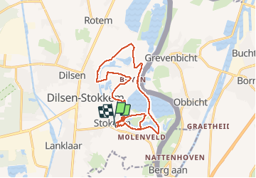
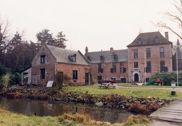
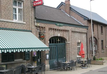
Randonnée Marche de 15,8 km à découvrir à Flandre, Limbourg, Dilsen-Stokkem. Cette randonnée est proposée par bometdehamer.
Description
Langs Oude Maas, de Grensmaas, Koeweide, Deurlingsweert, Maasveld, Visakker, Schaapskuil, Veurzen, Stokkemerweerd, Negenoord, Kerkeweerd en afsluiten langs de Ouzeir. Mooie wandeling!
Localisation
Pays :
Belgique
Région :
Flandre
Département/Province :
Limbourg
Commune :
Dilsen-Stokkem
Localité :
Stokkem
Départ:(Dec)
Départ:(UTM)
692517 ; 5655661 (31U) N.
Commentaires
Randonnées à proximité
![Randonnée A pied Maasmechelen - Erfgoedwandeling Eisden Tuinwijk - Photo](https://media.geolcdn.com/t/375/260/28db0122-7bbc-4a11-ae3a-faea898e04f5.jpeg&format=jpg&maxdim=2)
![A pied A pied](https://static1.geolcdn.com/sitytour/trail-icons/100.png)
Erfgoedwandeling Eisden Tuinwijk
A pied
Facile
Maasmechelen,
Flandre,
Limbourg,
Belgique
![](/images/other/stat-length.png)
3,1 km | 3,3 km-effort
44min
![](https://static1.geolcdn.com/siteimages/upload/files/16400158638029165_repeat_loop_refresh_sync_direction_icon.png)
Oui
![Randonnée A pied Dilsen-Stokkem - Stokkem & Oud-Dilsen Blauwe ruit - Photo](https://media.geolcdn.com/t/375/260/da26fab3-9e40-4ac6-a054-30a79ea1636f.jpeg&format=jpg&maxdim=2)
![A pied A pied](https://static1.geolcdn.com/sitytour/trail-icons/100.png)
Stokkem & Oud-Dilsen Blauwe ruit
A pied
Facile
Dilsen-Stokkem,
Flandre,
Limbourg,
Belgique
![](/images/other/stat-length.png)
4,7 km | 5 km-effort
1h 8min
![](https://static1.geolcdn.com/siteimages/upload/files/16400158638029165_repeat_loop_refresh_sync_direction_icon.png)
Oui
![Randonnée A pied Dilsen-Stokkem - Bergerven Gele zeshoek - Photo](https://media.geolcdn.com/t/375/260/050a923b-2af9-40e2-aacc-99779fc4e3d7.jpeg&format=jpg&maxdim=2)
![A pied A pied](https://static1.geolcdn.com/sitytour/trail-icons/100.png)
Bergerven Gele zeshoek
A pied
Facile
Dilsen-Stokkem,
Flandre,
Limbourg,
Belgique
![](/images/other/stat-length.png)
15,1 km | 17,5 km-effort
3h 58min
![](https://static1.geolcdn.com/siteimages/upload/files/16400158638029165_repeat_loop_refresh_sync_direction_icon.png)
Oui
![Randonnée A pied Dilsen-Stokkem - Bergerven Paarse trapezium - Photo](https://media.geolcdn.com/t/375/260/bd436d3d-7786-4c28-877a-e4f4a8ff02e7.jpeg&format=jpg&maxdim=2)
![A pied A pied](https://static1.geolcdn.com/sitytour/trail-icons/100.png)
Bergerven Paarse trapezium
A pied
Facile
Dilsen-Stokkem,
Flandre,
Limbourg,
Belgique
![](/images/other/stat-length.png)
13 km | 15 km-effort
3h 24min
![](https://static1.geolcdn.com/siteimages/upload/files/16400158638029165_repeat_loop_refresh_sync_direction_icon.png)
Oui
![Randonnée A pied Maasmechelen - Leut & Meeswijk Oranje bol - Photo](https://media.geolcdn.com/t/375/260/7b6d2e92-3c0b-4eee-8e68-d0c378b09212.jpeg&format=jpg&maxdim=2)
![A pied A pied](https://static1.geolcdn.com/sitytour/trail-icons/100.png)
Leut & Meeswijk Oranje bol
A pied
Facile
Maasmechelen,
Flandre,
Limbourg,
Belgique
![](/images/other/stat-length.png)
10,3 km | 11,2 km-effort
2h 33min
![](https://static1.geolcdn.com/siteimages/upload/files/16400158638029165_repeat_loop_refresh_sync_direction_icon.png)
Oui
![Randonnée A pied Maasmechelen - Leut & Meeswijk Rode driehoek - Photo](https://media.geolcdn.com/t/375/260/7b6d2e92-3c0b-4eee-8e68-d0c378b09212.jpeg&format=jpg&maxdim=2)
![A pied A pied](https://static1.geolcdn.com/sitytour/trail-icons/100.png)
Leut & Meeswijk Rode driehoek
A pied
Facile
Maasmechelen,
Flandre,
Limbourg,
Belgique
![](/images/other/stat-length.png)
14 km | 15 km-effort
3h 24min
![](https://static1.geolcdn.com/siteimages/upload/files/16400158638029165_repeat_loop_refresh_sync_direction_icon.png)
Oui
![Randonnée A pied Maasmechelen - Leut & Meeswijk Gele zeshoek - Photo](https://media.geolcdn.com/t/375/260/3a349166-7856-4cc9-a007-a2d01b733e80.jpeg&format=jpg&maxdim=2)
![A pied A pied](https://static1.geolcdn.com/sitytour/trail-icons/100.png)
Leut & Meeswijk Gele zeshoek
A pied
Facile
Maasmechelen,
Flandre,
Limbourg,
Belgique
![](/images/other/stat-length.png)
7 km | 7,4 km-effort
1h 40min
![](https://static1.geolcdn.com/siteimages/upload/files/16400158638029165_repeat_loop_refresh_sync_direction_icon.png)
Oui
![Randonnée A pied Maasmechelen - Leut & Meeswijk Groene rechthoek - Photo](https://media.geolcdn.com/t/375/260/7b6d2e92-3c0b-4eee-8e68-d0c378b09212.jpeg&format=jpg&maxdim=2)
![A pied A pied](https://static1.geolcdn.com/sitytour/trail-icons/100.png)
Leut & Meeswijk Groene rechthoek
A pied
Facile
Maasmechelen,
Flandre,
Limbourg,
Belgique
![](/images/other/stat-length.png)
3,5 km | 3,9 km-effort
53min
![](https://static1.geolcdn.com/siteimages/upload/files/16400158638029165_repeat_loop_refresh_sync_direction_icon.png)
Oui
![Randonnée A pied Maasmechelen - Leut & Meeswijk Blauwe ruit - Photo](https://media.geolcdn.com/t/375/260/7b6d2e92-3c0b-4eee-8e68-d0c378b09212.jpeg&format=jpg&maxdim=2)
![A pied A pied](https://static1.geolcdn.com/sitytour/trail-icons/100.png)
Leut & Meeswijk Blauwe ruit
A pied
Facile
Maasmechelen,
Flandre,
Limbourg,
Belgique
![](/images/other/stat-length.png)
5 km | 5,6 km-effort
1h 15min
![](https://static1.geolcdn.com/siteimages/upload/files/16400158638029165_repeat_loop_refresh_sync_direction_icon.png)
Oui