Randonnée Marche Saint-Hilaire-du-Harcouët - infir - Photo
 willy50
willy50

Utilisateur

© OpenStreetMap contributors
Longueur
Longueur
646 m
Altitude max
Altitude max
179 m
Dénivelé positif
Dénivelé positif
1 m
Km-Effort
Km-Effort  
662 m
Altitude min
Altitude min
176 m
Dénivelé négatif
Dénivelé négatif
2 m
Boucle
Boucle
Non
Date de création :
2020-01-28 08:04:01.976
Dernière modification :
2020-01-28 08:53:21.708

(0 Avis)

Marche
Marche
28m
Difficulté : Très facile

Scannez ce code QR pour ouvrir la randonnée dans l'application SityTrail

Application GPS de randonnée GRATUITE

Logo SityTrail SityTrail

IGN / Instituts géographiques

Télécharger SityTrail sur l'App Store Télécharger SityTrail sur Google Play

Logo SityTrail SityTrail World

Le monde est à vous

Télécharger SityTrail sur l'App Store Télécharger SityTrail sur Google Play Télécharger SityTrail sur Huawei AppGallery

À propos

Randonnée Marche de 646 m à découvrir à Normandie, Manche, Saint-Hilaire-du-Harcouët. Cette randonnée est proposée par willy50.

Profil altimétrique

Localisation

Pays :
France
Région :
Normandie
Département/Province :
Manche
Commune :
Saint-Hilaire-du-Harcouët
Localité :
Unknown
Départ:(UTM)
635116 ; 5378515 (30U) N.

Randonnées à proximité

Randonnée A pied Monthault - Paysages et couleurs - Photo
A pied
GUIDE+

A pied

Facile
Monthault, Bretagne, Ille-et-Vilaine, France
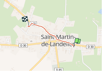
7,7 km | 9,6 km-effort
2h 10min
Oui
Randonnée Marche Saint-Brice-de-Landelles - Le Cerisier - Saint Brice de Landelles - Photo
Marche
tracegps

Marche

Facile
Saint-Brice-de-Landelles, Normandie, Manche, France
6,4 km | 7,7 km-effort
1h 19min
Oui
Randonnée Marche Monthault - Monthault - Photo
Marche
neoroll44

Marche

Moyen
Monthault, Bretagne, Ille-et-Vilaine, France
7,5 km | 9,5 km-effort
2h 20min
Oui
Randonnée Marche Monthault - monthault - Photo
Marche
CANON2

Marche

Très facile
Monthault, Bretagne, Ille-et-Vilaine, France
5,9 km | 7,3 km-effort
1h 36min
Oui


Fermer
Mes abonnements