![](/images/other/stat-length.png)
![Randonnée Marche Marsas - Marsas - Photo](https://media.geolcdn.com/t/1900/400/4b4e1a06-4c06-438b-b0b3-9fc2798fdfd6.jpg&format=pjpeg&maxdim=2)
Marsas
bedous
Utilisateur
![Longueur](/images/other/stat-length.png)
Longueur
18,7 km
![Altitude max](https://static1.geolcdn.com/siteimages/upload/files/1508320355ic_sort_altitude_max_24dp.png)
Altitude max
70 m
![Dénivelé positif](https://static1.geolcdn.com/siteimages/upload/files/1508320355ic_sort_den_pos_24dp.png)
Dénivelé positif
134 m
![Km-Effort](/images/other/stat-length.png)
Km-Effort
20 km
![Altitude min](https://static1.geolcdn.com/siteimages/upload/files/1508320355ic_sort_altitude_min_24dp.png)
Altitude min
18 m
![Dénivelé négatif](https://static1.geolcdn.com/siteimages/upload/files/1508320355ic_sort_den_neg_24dp.png)
Dénivelé négatif
135 m
![Boucle](https://static1.geolcdn.com/siteimages/upload/files/16400158638029165_repeat_loop_refresh_sync_direction_icon.png)
Boucle
Oui
Date de création :
2020-01-26 08:26:38.524
Dernière modification :
2020-01-26 16:56:40.812
![Marche](https://static1.geolcdn.com/sitytour/trail-icons/101.png)
4h59
Difficulté : Facile
![Scannez ce code QR pour ouvrir la randonnée dans l'application SityTrail](https://capi.geolives.com/qq0zvz2zws4bq2lad0pu/sitytour/trails/2315818/qr.png?size=200)
Application GPS de randonnée GRATUITE
À propos
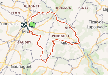
Randonnée Marche de 18,7 km à découvrir à Nouvelle-Aquitaine, Gironde, Marsas. Cette randonnée est proposée par bedous.
Description
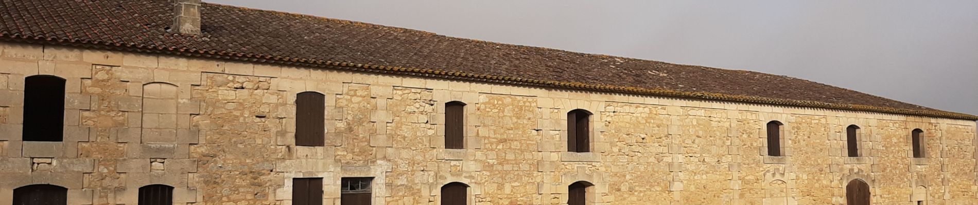
Randonnée au travers des bois et prairies. Trés belle église templière à Marcenais. Trés beau moulin sur le parcours. De belles fermes anciennes.
Localisation
Pays :
France
Région :
Nouvelle-Aquitaine
Département/Province :
Gironde
Commune :
Marsas
Localité :
Unknown
Départ:(Dec)
Départ:(UTM)
705904 ; 4993781 (30T) N.
Commentaires
Randonnées à proximité
![Randonnée Marche Marcenais - balade chien - Photo](https://media.geolcdn.com/t/375/260/9f8efaf3-8634-4bd0-aebd-7ebbf1feb79a.jpg&format=jpg&maxdim=2)
![Marche Marche](https://static1.geolcdn.com/sitytour/trail-icons/101.png)
balade chien
Marche
Facile
Marcenais,
Nouvelle-Aquitaine,
Gironde,
France
![](/images/other/stat-length.png)
8,2 km | 9,2 km-effort
1h 34min
![](https://static1.geolcdn.com/siteimages/upload/files/16400158638029165_repeat_loop_refresh_sync_direction_icon.png)
Oui
![Randonnée V.T.T. Marsas - 190622 - Photo](https://media.geolcdn.com/t/375/260/1203ccb0-4703-4a61-a5d9-eb57b8da09fb.jpg&format=jpg&maxdim=2)
![V.T.T. V.T.T.](https://static1.geolcdn.com/sitytour/trail-icons/202.png)
190622
V.T.T.
Très facile
Marsas,
Nouvelle-Aquitaine,
Gironde,
France
![](/images/other/stat-length.png)
16,7 km | 18,5 km-effort
1h 4min
![](https://static1.geolcdn.com/siteimages/upload/files/16400158638029165_repeat_loop_refresh_sync_direction_icon.png)
Oui
![Randonnée Marche Cubnezais - cubnesais - Photo](https://media.geolcdn.com/t/375/260/ext.jpg?maxdim=2&url=https%3A%2F%2Fstatic1.geolcdn.com%2Fsiteimages%2Fupload%2Ffiles%2F1553511878bg_sport_marche.png)
![Marche Marche](https://static1.geolcdn.com/sitytour/trail-icons/101.png)
cubnesais
Marche
Très facile
Cubnezais,
Nouvelle-Aquitaine,
Gironde,
France
![](/images/other/stat-length.png)
13,5 km | 14,7 km-effort
3h 30min
![](https://static1.geolcdn.com/siteimages/upload/files/16400158638029165_repeat_loop_refresh_sync_direction_icon.png)
Oui
![Randonnée Marche Saint-Genès-de-Fronsac - saint gènes de Fonsac - Photo](https://media.geolcdn.com/t/375/260/ext.jpg?maxdim=2&url=https%3A%2F%2Fstatic1.geolcdn.com%2Fsiteimages%2Fupload%2Ffiles%2F1553511878bg_sport_marche.png)
![Marche Marche](https://static1.geolcdn.com/sitytour/trail-icons/101.png)
saint gènes de Fonsac
Marche
Très difficile
Saint-Genès-de-Fronsac,
Nouvelle-Aquitaine,
Gironde,
France
![](/images/other/stat-length.png)
19 km | 22 km-effort
4h 58min
![](https://static1.geolcdn.com/siteimages/upload/files/16400158638029165_repeat_loop_refresh_sync_direction_icon.png)
Oui
![Randonnée Marche Peujard - peujeard - Photo](https://media.geolcdn.com/t/375/260/ext.jpg?maxdim=2&url=https%3A%2F%2Fstatic1.geolcdn.com%2Fsiteimages%2Fupload%2Ffiles%2F1553511878bg_sport_marche.png)
![Marche Marche](https://static1.geolcdn.com/sitytour/trail-icons/101.png)
peujeard
Marche
Très facile
Peujard,
Nouvelle-Aquitaine,
Gironde,
France
![](/images/other/stat-length.png)
13,1 km | 14,3 km-effort
3h 9min
![](https://static1.geolcdn.com/siteimages/upload/files/16400158638029165_repeat_loop_refresh_sync_direction_icon.png)
Oui
![Randonnée Marche Marcenais - balade du chien - Photo](https://media.geolcdn.com/t/375/260/ext.jpg?maxdim=2&url=https%3A%2F%2Fstatic1.geolcdn.com%2Fsiteimages%2Fupload%2Ffiles%2F1553511878bg_sport_marche.png)
![Marche Marche](https://static1.geolcdn.com/sitytour/trail-icons/101.png)
balade du chien
Marche
Très facile
Marcenais,
Nouvelle-Aquitaine,
Gironde,
France
![](/images/other/stat-length.png)
8,2 km | 9,2 km-effort
1h 37min
![](https://static1.geolcdn.com/siteimages/upload/files/16400158638029165_repeat_loop_refresh_sync_direction_icon.png)
Oui
![Randonnée Marche Marcenais - promenade avec mon chien - Photo](https://media.geolcdn.com/t/375/260/ext.jpg?maxdim=2&url=https%3A%2F%2Fstatic1.geolcdn.com%2Fsiteimages%2Fupload%2Ffiles%2F1553511878bg_sport_marche.png)
![Marche Marche](https://static1.geolcdn.com/sitytour/trail-icons/101.png)
promenade avec mon chien
Marche
Facile
Marcenais,
Nouvelle-Aquitaine,
Gironde,
France
![](/images/other/stat-length.png)
10,9 km | 12,5 km-effort
2h 44min
![](https://static1.geolcdn.com/siteimages/upload/files/16400158638029165_repeat_loop_refresh_sync_direction_icon.png)
Oui
![Randonnée Vélo Marcenais - amap - Photo](https://media.geolcdn.com/t/375/260/ext.jpg?maxdim=2&url=https%3A%2F%2Fstatic1.geolcdn.com%2Fsiteimages%2Fupload%2Ffiles%2F1524743154velo.jpg)
![Vélo Vélo](https://static1.geolcdn.com/sitytour/trail-icons/200.png)
![Randonnée V.T.T. Marsas - Marsas - Photo](https://media.geolcdn.com/t/375/260/ext.jpg?maxdim=2&url=https%3A%2F%2Fstatic1.geolcdn.com%2Fsiteimages%2Fupload%2Ffiles%2F1524743154velo.jpg)
![V.T.T. V.T.T.](https://static1.geolcdn.com/sitytour/trail-icons/202.png)