![](/images/other/stat-length.png)
![Randonnée V.T.T. Verviers - VAE Stembert / Gileppe / Stembert 40Km - Photo](https://media.geolcdn.com/t/1900/400/ext.pjpeg?maxdim=2&url=https%3A%2F%2Fstatic1.geolcdn.com%2Fsiteimages%2Fupload%2Ffiles%2F1524743154velo.jpg)
VAE Stembert / Gileppe / Stembert 40Km
didier.cavillot
Utilisateur
![Longueur](/images/other/stat-length.png)
Longueur
42 km
![Altitude max](https://static1.geolcdn.com/siteimages/upload/files/1508320355ic_sort_altitude_max_24dp.png)
Altitude max
377 m
![Dénivelé positif](https://static1.geolcdn.com/siteimages/upload/files/1508320355ic_sort_den_pos_24dp.png)
Dénivelé positif
866 m
![Km-Effort](/images/other/stat-length.png)
Km-Effort
53 km
![Altitude min](https://static1.geolcdn.com/siteimages/upload/files/1508320355ic_sort_altitude_min_24dp.png)
Altitude min
251 m
![Dénivelé négatif](https://static1.geolcdn.com/siteimages/upload/files/1508320355ic_sort_den_neg_24dp.png)
Dénivelé négatif
866 m
![Boucle](https://static1.geolcdn.com/siteimages/upload/files/16400158638029165_repeat_loop_refresh_sync_direction_icon.png)
Boucle
Oui
Date de création :
2020-01-16 16:59:13.208
Dernière modification :
2020-11-02 22:38:45.829
![V.T.T.](https://static1.geolcdn.com/sitytour/trail-icons/202.png)
3h29
Difficulté : Très difficile
![Scannez ce code QR pour ouvrir la randonnée dans l'application SityTrail](https://capi.geolives.com/qq0zvz2zws4bq2lad0pu/sitytour/trails/2307261/qr.png?size=200)
Application GPS de randonnée GRATUITE
À propos
Randonnée V.T.T. de 42 km à découvrir à Wallonie, Liège, Verviers. Cette randonnée est proposée par didier.cavillot.
Description
Trace VTT Départ Stembert boucle Bois de Halleur / Gileppe / Hevreumont / Gileppe / Parking / boucle Chêne du RDV / retour Stembert via bois de Halleur
Localisation
Pays :
Belgique
Région :
Wallonie
Département/Province :
Liège
Commune :
Verviers
Localité :
Stembert
Départ:(Dec)
Départ:(UTM)
704312 ; 5608310 (31U) N.
Commentaires
Randonnées à proximité
![Randonnée Marche Limbourg - RB-Lg-28_Limbourg - Photo](https://media.geolcdn.com/t/375/260/ext.jpg?maxdim=2&url=https%3A%2F%2Fservices.sitytrail.com%2FGeolivesWS%2FDownloadMedia.ashx%3FTrailID%3D402093%26Media%3D979895a6-f139-4f7a-8335-2e926c1b89c7.jpg)
![Marche Marche](https://static1.geolcdn.com/sitytour/trail-icons/101.png)
RB-Lg-28_Limbourg
Marche
(5)
Limbourg,
Wallonie,
Liège,
Belgique
![](/images/other/stat-length.png)
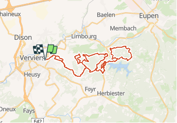
19,9 km | 26 km-effort
5h 49min
![](https://static1.geolcdn.com/siteimages/upload/files/16400158638029165_repeat_loop_refresh_sync_direction_icon.png)
Oui
![Randonnée Marche Verviers - Grand vivier - Cossart - Photo](https://media.geolcdn.com/t/375/260/ext.jpg?maxdim=2&url=https%3A%2F%2Fstatic1.geolcdn.com%2Fsiteimages%2Fupload%2Ffiles%2F1553511878bg_sport_marche.png)
![Marche Marche](https://static1.geolcdn.com/sitytour/trail-icons/101.png)
Grand vivier - Cossart
Marche
Facile
(5)
Verviers,
Wallonie,
Liège,
Belgique
![](/images/other/stat-length.png)
4,7 km | 6,4 km-effort
1h 26min
![](https://static1.geolcdn.com/siteimages/upload/files/16400158638029165_repeat_loop_refresh_sync_direction_icon.png)
Oui
![Marche Marche](https://static1.geolcdn.com/sitytour/trail-icons/101.png)
20220901 - Jehanster 5.3 Km
Marche
Moyen
(1)
Theux,
Wallonie,
Liège,
Belgique
![](/images/other/stat-length.png)
5,3 km | 6,8 km-effort
1h 32min
![](https://static1.geolcdn.com/siteimages/upload/files/16400158638029165_repeat_loop_refresh_sync_direction_icon.png)
Oui
![Randonnée Marche Limbourg - RL-GG-11_Dolhain-Gileppe_Pepinster - Photo](https://media.geolcdn.com/t/375/260/9cf2c240-5913-4088-b4f6-6c0e1fae0233.jpg&format=jpg&maxdim=2)
![Marche Marche](https://static1.geolcdn.com/sitytour/trail-icons/101.png)
RL-GG-11_Dolhain-Gileppe_Pepinster
Marche
Très difficile
(2)
Limbourg,
Wallonie,
Liège,
Belgique
![](/images/other/stat-length.png)
20 km | 26 km-effort
5h 33min
![](https://static1.geolcdn.com/siteimages/upload/files/16400158638029165_repeat_loop_refresh_sync_direction_icon.png)
Non
![Randonnée Marche Limbourg - 20200606 - Hèvremont 8 Km - Photo](https://media.geolcdn.com/t/375/260/8311f513-ce09-455a-b0ac-51a7423b07df.jpg&format=jpg&maxdim=2)
![Marche Marche](https://static1.geolcdn.com/sitytour/trail-icons/101.png)
20200606 - Hèvremont 8 Km
Marche
Difficile
(1)
Limbourg,
Wallonie,
Liège,
Belgique
![](/images/other/stat-length.png)
7,9 km | 10,7 km-effort
1h 34min
![](https://static1.geolcdn.com/siteimages/upload/files/16400158638029165_repeat_loop_refresh_sync_direction_icon.png)
Oui
![Randonnée Marche Verviers - Stembert . les Roudoudous . Stembert - Photo](https://media.geolcdn.com/t/375/260/83013b57-22fc-4f55-b86f-1cd16e0258d4.jpg&format=jpg&maxdim=2)
![Marche Marche](https://static1.geolcdn.com/sitytour/trail-icons/101.png)
Stembert . les Roudoudous . Stembert
Marche
Facile
(2)
Verviers,
Wallonie,
Liège,
Belgique
![](/images/other/stat-length.png)
10,5 km | 13,5 km-effort
2h 48min
![](https://static1.geolcdn.com/siteimages/upload/files/16400158638029165_repeat_loop_refresh_sync_direction_icon.png)
Oui
![Randonnée Marche Theux - jehanster . croix du petit Jean . vervifontaine . foyr . surister . jehanster - Photo](https://media.geolcdn.com/t/375/260/72aa6408-0b0f-4111-b439-9ca6df2a9f8b.jpg&format=jpg&maxdim=2)
![Marche Marche](https://static1.geolcdn.com/sitytour/trail-icons/101.png)
jehanster . croix du petit Jean . vervifontaine . foyr . surister . jehanster
Marche
Facile
(2)
Theux,
Wallonie,
Liège,
Belgique
![](/images/other/stat-length.png)
9,9 km | 11,9 km-effort
2h 31min
![](https://static1.geolcdn.com/siteimages/upload/files/16400158638029165_repeat_loop_refresh_sync_direction_icon.png)
Oui
![Randonnée Marche Theux - Chemin des Sources |étape n°7 JEHANSTER – THEUX - Photo](https://media.geolcdn.com/t/375/260/328c52f8-b1ec-4c2a-838b-06aafb93e491.jpg&format=jpg&maxdim=2)
![Marche Marche](https://static1.geolcdn.com/sitytour/trail-icons/101.png)
Chemin des Sources |étape n°7 JEHANSTER – THEUX
Marche
Très difficile
(2)
Theux,
Wallonie,
Liège,
Belgique
![](/images/other/stat-length.png)
15,2 km | 19,2 km-effort
4h 21min
![](https://static1.geolcdn.com/siteimages/upload/files/16400158638029165_repeat_loop_refresh_sync_direction_icon.png)
Non
![Randonnée V.T.T. Verviers - VAE Stembert/Gileppe/Eupen/Mariehomont 40Km - Photo](https://media.geolcdn.com/t/375/260/065d690c-d4f8-46e5-b8c7-553390be2eee.jpg&format=jpg&maxdim=2)
![V.T.T. V.T.T.](https://static1.geolcdn.com/sitytour/trail-icons/202.png)
VAE Stembert/Gileppe/Eupen/Mariehomont 40Km
V.T.T.
Très difficile
(1)
Verviers,
Wallonie,
Liège,
Belgique
![](/images/other/stat-length.png)
41 km | 55 km-effort
3h 50min
![](https://static1.geolcdn.com/siteimages/upload/files/16400158638029165_repeat_loop_refresh_sync_direction_icon.png)
Oui