![](/images/other/stat-length.png)
![Randonnée V.T.T. Jalhay - VAE Gileppe boucle +/- 35Km - Photo](https://media.geolcdn.com/t/1900/400/ext.pjpeg?maxdim=2&url=https%3A%2F%2Fstatic1.geolcdn.com%2Fsiteimages%2Fupload%2Ffiles%2F1524743154velo.jpg)
VAE Gileppe boucle +/- 35Km
didier.cavillot
Utilisateur
![Longueur](/images/other/stat-length.png)
Longueur
33 km
![Altitude max](https://static1.geolcdn.com/siteimages/upload/files/1508320355ic_sort_altitude_max_24dp.png)
Altitude max
385 m
![Dénivelé positif](https://static1.geolcdn.com/siteimages/upload/files/1508320355ic_sort_den_pos_24dp.png)
Dénivelé positif
740 m
![Km-Effort](/images/other/stat-length.png)
Km-Effort
43 km
![Altitude min](https://static1.geolcdn.com/siteimages/upload/files/1508320355ic_sort_altitude_min_24dp.png)
Altitude min
255 m
![Dénivelé négatif](https://static1.geolcdn.com/siteimages/upload/files/1508320355ic_sort_den_neg_24dp.png)
Dénivelé négatif
742 m
![Boucle](https://static1.geolcdn.com/siteimages/upload/files/16400158638029165_repeat_loop_refresh_sync_direction_icon.png)
Boucle
Oui
Date de création :
2020-01-15 15:54:13.139
Dernière modification :
2020-11-02 22:37:43.201
![V.T.T.](https://static1.geolcdn.com/sitytour/trail-icons/202.png)
45m
Difficulté : Facile
![Scannez ce code QR pour ouvrir la randonnée dans l'application SityTrail](https://capi.geolives.com/qq0zvz2zws4bq2lad0pu/sitytour/trails/2306239/qr.png?size=200)
Application GPS de randonnée GRATUITE
À propos
Randonnée V.T.T. de 33 km à découvrir à Wallonie, Liège, Jalhay. Cette randonnée est proposée par didier.cavillot.
Description
Trace VTT Départ Gileppe boucle via la Louveterie / Hevremont / Chêne du RDV. Passage à 20Km sur le parking de la Gileppe pour le ravito de 1/2 rando.
Localisation
Pays :
Belgique
Région :
Wallonie
Département/Province :
Liège
Commune :
Jalhay
Localité :
Jalhay
Départ:(Dec)
Départ:(UTM)
710195 ; 5608224 (31U) N.
Commentaires
Randonnées à proximité
![Randonnée Marche Limbourg - RB-Lg-28_Limbourg - Photo](https://media.geolcdn.com/t/375/260/ext.jpg?maxdim=2&url=https%3A%2F%2Fservices.sitytrail.com%2FGeolivesWS%2FDownloadMedia.ashx%3FTrailID%3D402093%26Media%3D979895a6-f139-4f7a-8335-2e926c1b89c7.jpg)
![Marche Marche](https://static1.geolcdn.com/sitytour/trail-icons/101.png)
RB-Lg-28_Limbourg
Marche
(5)
Limbourg,
Wallonie,
Liège,
Belgique
![](/images/other/stat-length.png)
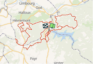
19,9 km | 26 km-effort
5h 49min
![](https://static1.geolcdn.com/siteimages/upload/files/16400158638029165_repeat_loop_refresh_sync_direction_icon.png)
Oui
![Randonnée Marche Jalhay - La Gileppe - Bois de la Borchêne - Photo](https://media.geolcdn.com/t/375/260/e6c1c191-9060-48ef-8a65-d77cc5b69a34.jpg&format=jpg&maxdim=2)
![Marche Marche](https://static1.geolcdn.com/sitytour/trail-icons/101.png)
La Gileppe - Bois de la Borchêne
Marche
Facile
(3)
Jalhay,
Wallonie,
Liège,
Belgique
![](/images/other/stat-length.png)
7,6 km | 9,8 km-effort
2h 13min
![](https://static1.geolcdn.com/siteimages/upload/files/16400158638029165_repeat_loop_refresh_sync_direction_icon.png)
Oui
![Randonnée Marche Baelen - Baelen - Eupen 🎄🎅 - Membach - Photo](https://media.geolcdn.com/t/375/260/d50227a7-424d-470e-90d5-87ebd384de36.jpg&format=jpg&maxdim=2)
![Marche Marche](https://static1.geolcdn.com/sitytour/trail-icons/101.png)
Baelen - Eupen 🎄🎅 - Membach
Marche
Facile
(1)
Baelen,
Wallonie,
Liège,
Belgique
![](/images/other/stat-length.png)
13,3 km | 15,6 km-effort
3h 32min
![](https://static1.geolcdn.com/siteimages/upload/files/16400158638029165_repeat_loop_refresh_sync_direction_icon.png)
Oui
![Randonnée Marche Eupen - Autour d'Eupen - Photo](https://media.geolcdn.com/t/375/260/2e56e8e4-4348-489f-86b5-c8ca8af64230.jpg&format=jpg&maxdim=2)
![Marche Marche](https://static1.geolcdn.com/sitytour/trail-icons/101.png)
Autour d'Eupen
Marche
Facile
(1)
Eupen,
Wallonie,
Liège,
Belgique
![](/images/other/stat-length.png)
13,3 km | 16,4 km-effort
3h 43min
![](https://static1.geolcdn.com/siteimages/upload/files/16400158638029165_repeat_loop_refresh_sync_direction_icon.png)
Oui
![Randonnée Marche Jalhay - Jalhay-Royompré_-_Balade 47 - Photo](https://media.geolcdn.com/t/375/260/94c262e0-20e7-4ae2-8b45-01b4c31da73b.jpg&format=jpg&maxdim=2)
![Marche Marche](https://static1.geolcdn.com/sitytour/trail-icons/101.png)
Jalhay-Royompré_-_Balade 47
Marche
Facile
(2)
Jalhay,
Wallonie,
Liège,
Belgique
![](/images/other/stat-length.png)
11 km | 13,9 km-effort
3h 9min
![](https://static1.geolcdn.com/siteimages/upload/files/16400158638029165_repeat_loop_refresh_sync_direction_icon.png)
Oui
![Randonnée Marche Eupen - Eupen - Photo](https://media.geolcdn.com/t/375/260/d87483d2-4d3d-461a-a9c9-ec45b2516003.jpg&format=jpg&maxdim=2)
![Marche Marche](https://static1.geolcdn.com/sitytour/trail-icons/101.png)
![Randonnée Marche Baelen - La Montagne du Dragon - Photo](https://media.geolcdn.com/t/375/260/3a1bc634-7bf5-4748-bbb3-513b265a48b5.jpg&format=jpg&maxdim=2)
![Marche Marche](https://static1.geolcdn.com/sitytour/trail-icons/101.png)
La Montagne du Dragon
Marche
Facile
(1)
Baelen,
Wallonie,
Liège,
Belgique
![](/images/other/stat-length.png)
16,2 km | 21 km-effort
3h 21min
![](https://static1.geolcdn.com/siteimages/upload/files/16400158638029165_repeat_loop_refresh_sync_direction_icon.png)
Oui
![Marche Marche](https://static1.geolcdn.com/sitytour/trail-icons/101.png)
20210205 - La Gileppe 7.3 Km
Marche
Moyen
(1)
Jalhay,
Wallonie,
Liège,
Belgique
![](/images/other/stat-length.png)
7,6 km | 9,9 km-effort
2h 24min
![](https://static1.geolcdn.com/siteimages/upload/files/16400158638029165_repeat_loop_refresh_sync_direction_icon.png)
Oui
![Randonnée Marche Limbourg - RL-GG-11_Dolhain-Gileppe_Pepinster - Photo](https://media.geolcdn.com/t/375/260/9cf2c240-5913-4088-b4f6-6c0e1fae0233.jpg&format=jpg&maxdim=2)
![Marche Marche](https://static1.geolcdn.com/sitytour/trail-icons/101.png)
RL-GG-11_Dolhain-Gileppe_Pepinster
Marche
Très difficile
(2)
Limbourg,
Wallonie,
Liège,
Belgique
![](/images/other/stat-length.png)
20 km | 26 km-effort
5h 33min
![](https://static1.geolcdn.com/siteimages/upload/files/16400158638029165_repeat_loop_refresh_sync_direction_icon.png)
Non