![](/images/other/stat-length.png)
![Randonnée A pied Cloyes-les-Trois-Rivières - Montigny le Gannelon courte matin PC26sept2020 - Photo](https://media.geolcdn.com/t/1900/400/ext.pjpeg?maxdim=2&url=https%3A%2F%2Fstatic1.geolcdn.com%2Fsiteimages%2Fupload%2Ffiles%2F1545311037marcheuse_200dpi.jpg)
Montigny le Gannelon courte matin PC26sept2020
CRUZILLACP
Utilisateur
![Longueur](/images/other/stat-length.png)
Longueur
7 km
![Altitude max](https://static1.geolcdn.com/siteimages/upload/files/1508320355ic_sort_altitude_max_24dp.png)
Altitude max
147 m
![Dénivelé positif](https://static1.geolcdn.com/siteimages/upload/files/1508320355ic_sort_den_pos_24dp.png)
Dénivelé positif
84 m
![Km-Effort](/images/other/stat-length.png)
Km-Effort
8,1 km
![Altitude min](https://static1.geolcdn.com/siteimages/upload/files/1508320355ic_sort_altitude_min_24dp.png)
Altitude min
94 m
![Dénivelé négatif](https://static1.geolcdn.com/siteimages/upload/files/1508320355ic_sort_den_neg_24dp.png)
Dénivelé négatif
88 m
![Boucle](https://static1.geolcdn.com/siteimages/upload/files/16400158638029165_repeat_loop_refresh_sync_direction_icon.png)
Boucle
Non
Date de création :
2020-01-14 13:45:52.739
Dernière modification :
2020-02-03 09:54:33.023
![A pied](https://static1.geolcdn.com/sitytour/trail-icons/100.png)
--
Difficulté : Facile
![Scannez ce code QR pour ouvrir la randonnée dans l'application SityTrail](https://capi.geolives.com/qq0zvz2zws4bq2lad0pu/sitytour/trails/2305190/qr.png?size=200)
Application GPS de randonnée GRATUITE
À propos
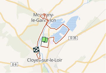
Randonnée A pied de 7 km à découvrir à Centre-Val de Loire, Eure-et-Loir, Cloyes-les-Trois-Rivières. Cette randonnée est proposée par CRUZILLACP.
Description
Départ Cloyes camping Le Val Fleuri
Partie du circuit Héron
Montigny le Gannelon
Pique nique Parc Emile Zola à Cloyes
Localisation
Pays :
France
Région :
Centre-Val de Loire
Département/Province :
Eure-et-Loir
Commune :
Cloyes-les-Trois-Rivières
Localité :
Cloyes-sur-le-Loir
Départ:(Dec)
Départ:(UTM)
368103 ; 5318105 (31U) N.
Commentaires
Randonnées à proximité
![Randonnée Marche Cloyes-les-Trois-Rivières - Voie de Tours : 4 ème étape Cloyes - Vrndome - Poirier - Photo](https://media.geolcdn.com/t/375/260/28d4a587-913c-4aff-8e11-65ec6298b2ab.jpg&format=jpg&maxdim=2)
![Marche Marche](https://static1.geolcdn.com/sitytour/trail-icons/101.png)
Voie de Tours : 4 ème étape Cloyes - Vrndome - Poirier
Marche
Difficile
Cloyes-les-Trois-Rivières,
Centre-Val de Loire,
Eure-et-Loir,
France
![](/images/other/stat-length.png)
44 km | 49 km-effort
8h 20min
![](https://static1.geolcdn.com/siteimages/upload/files/16400158638029165_repeat_loop_refresh_sync_direction_icon.png)
Non
![Randonnée Marche Cloyes-les-Trois-Rivières - circuit du chevreuil - Photo](https://media.geolcdn.com/t/375/260/ext.jpg?maxdim=2&url=https%3A%2F%2Fstatic1.geolcdn.com%2Fsiteimages%2Fupload%2Ffiles%2F1553511878bg_sport_marche.png)
![Marche Marche](https://static1.geolcdn.com/sitytour/trail-icons/101.png)
circuit du chevreuil
Marche
Très facile
Cloyes-les-Trois-Rivières,
Centre-Val de Loire,
Eure-et-Loir,
France
![](/images/other/stat-length.png)
6 km | 6,7 km-effort
1h 48min
![](https://static1.geolcdn.com/siteimages/upload/files/16400158638029165_repeat_loop_refresh_sync_direction_icon.png)
Non
![Randonnée Marche Cloyes-les-Trois-Rivières - Montigny le guenelon - Photo](https://media.geolcdn.com/t/375/260/ext.jpg?maxdim=2&url=https%3A%2F%2Fstatic1.geolcdn.com%2Fsiteimages%2Fupload%2Ffiles%2F1553511878bg_sport_marche.png)
![Marche Marche](https://static1.geolcdn.com/sitytour/trail-icons/101.png)
Montigny le guenelon
Marche
Facile
Cloyes-les-Trois-Rivières,
Centre-Val de Loire,
Eure-et-Loir,
France
![](/images/other/stat-length.png)
21 km | 24 km-effort
6h 40min
![](https://static1.geolcdn.com/siteimages/upload/files/16400158638029165_repeat_loop_refresh_sync_direction_icon.png)
Non
![Randonnée Marche Cloyes-les-Trois-Rivières - cloyes sur Loir - Photo](https://media.geolcdn.com/t/375/260/1e35d3dc-a027-4977-abd7-a051dbba0c52.jpg&format=jpg&maxdim=2)
![Marche Marche](https://static1.geolcdn.com/sitytour/trail-icons/101.png)
cloyes sur Loir
Marche
Facile
Cloyes-les-Trois-Rivières,
Centre-Val de Loire,
Eure-et-Loir,
France
![](/images/other/stat-length.png)
6,3 km | 7 km-effort
2h 7min
![](https://static1.geolcdn.com/siteimages/upload/files/16400158638029165_repeat_loop_refresh_sync_direction_icon.png)
Oui
![Randonnée Marche Cloyes-les-Trois-Rivières - St-Hilaire-sur-Yerre - Photo](https://media.geolcdn.com/t/375/260/ext.jpg?maxdim=2&url=https%3A%2F%2Fstatic1.geolcdn.com%2Fsiteimages%2Fupload%2Ffiles%2F1553511878bg_sport_marche.png)
![Marche Marche](https://static1.geolcdn.com/sitytour/trail-icons/101.png)
St-Hilaire-sur-Yerre
Marche
Moyen
Cloyes-les-Trois-Rivières,
Centre-Val de Loire,
Eure-et-Loir,
France
![](/images/other/stat-length.png)
18,1 km | 21 km-effort
4h 30min
![](https://static1.geolcdn.com/siteimages/upload/files/16400158638029165_repeat_loop_refresh_sync_direction_icon.png)
Oui
![Randonnée A pied Cloyes-les-Trois-Rivières - Douy PC27sept2020 - Photo](https://media.geolcdn.com/t/375/260/ext.jpg?maxdim=2&url=https%3A%2F%2Fstatic1.geolcdn.com%2Fsiteimages%2Fupload%2Ffiles%2F1545311037marcheuse_200dpi.jpg)
![A pied A pied](https://static1.geolcdn.com/sitytour/trail-icons/100.png)
Douy PC27sept2020
A pied
Moyen
Cloyes-les-Trois-Rivières,
Centre-Val de Loire,
Eure-et-Loir,
France
![](/images/other/stat-length.png)
11,3 km | 13 km-effort
Inconnu
![](https://static1.geolcdn.com/siteimages/upload/files/16400158638029165_repeat_loop_refresh_sync_direction_icon.png)
Oui
![Randonnée A pied Cloyes-les-Trois-Rivières - Montigny le Gannelon classique matin PC26sept2020 - Photo](https://media.geolcdn.com/t/375/260/ext.jpg?maxdim=2&url=https%3A%2F%2Fstatic1.geolcdn.com%2Fsiteimages%2Fupload%2Ffiles%2F1545311037marcheuse_200dpi.jpg)
![A pied A pied](https://static1.geolcdn.com/sitytour/trail-icons/100.png)
Montigny le Gannelon classique matin PC26sept2020
A pied
Moyen
Cloyes-les-Trois-Rivières,
Centre-Val de Loire,
Eure-et-Loir,
France
![](/images/other/stat-length.png)
12,2 km | 13,8 km-effort
Inconnu
![](https://static1.geolcdn.com/siteimages/upload/files/16400158638029165_repeat_loop_refresh_sync_direction_icon.png)
Non
![Randonnée Voiture Villebout - 2019-11-10 belle de - Photo](https://media.geolcdn.com/t/375/260/ext.jpg?maxdim=2&url=https%3A%2F%2Fstatic1.geolcdn.com%2Fsiteimages%2Fupload%2Ffiles%2F15247431544x4.jpg)
![Voiture Voiture](https://static1.geolcdn.com/sitytour/trail-icons/401.png)
2019-11-10 belle de
Voiture
Villebout,
Centre-Val de Loire,
Loir-et-Cher,
France
![](/images/other/stat-length.png)
8,6 km | 9,4 km-effort
3h 6min
![](https://static1.geolcdn.com/siteimages/upload/files/16400158638029165_repeat_loop_refresh_sync_direction_icon.png)
Non
![Randonnée Marche Cloyes-les-Trois-Rivières - 010 Cloyes Vendome - Photo](https://media.geolcdn.com/t/375/260/ext.jpg?maxdim=2&url=https%3A%2F%2Fstatic1.geolcdn.com%2Fsiteimages%2Fupload%2Ffiles%2F1553511878bg_sport_marche.png)
![Marche Marche](https://static1.geolcdn.com/sitytour/trail-icons/101.png)
010 Cloyes Vendome
Marche
Très facile
Cloyes-les-Trois-Rivières,
Centre-Val de Loire,
Eure-et-Loir,
France
![](/images/other/stat-length.png)
36 km | 40 km-effort
8h 43min
![](https://static1.geolcdn.com/siteimages/upload/files/16400158638029165_repeat_loop_refresh_sync_direction_icon.png)
Non