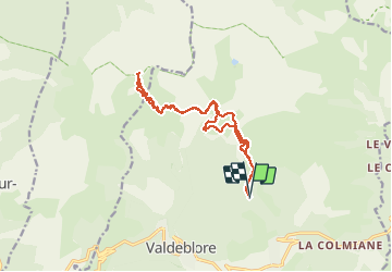
![](/images/other/stat-length.png)
![Randonnée Ski de randonnée Valdeblore - Mont Giraud - Photo](https://media.geolcdn.com/t/1900/400/d60de159-00c0-455c-8a64-fbf85ef6a7de.jpg&format=pjpeg&maxdim=2)
Mont Giraud
nadd73
Utilisateur GUIDE
![Longueur](/images/other/stat-length.png)
![Altitude max](https://static1.geolcdn.com/siteimages/upload/files/1508320355ic_sort_altitude_max_24dp.png)
![Dénivelé positif](https://static1.geolcdn.com/siteimages/upload/files/1508320355ic_sort_den_pos_24dp.png)
![Km-Effort](/images/other/stat-length.png)
![Altitude min](https://static1.geolcdn.com/siteimages/upload/files/1508320355ic_sort_altitude_min_24dp.png)
![Dénivelé négatif](https://static1.geolcdn.com/siteimages/upload/files/1508320355ic_sort_den_neg_24dp.png)
![Boucle](https://static1.geolcdn.com/siteimages/upload/files/16400158638029165_repeat_loop_refresh_sync_direction_icon.png)
![Ski de randonnée](https://static1.geolcdn.com/sitytour/trail-icons/503.png)
7h41
Difficulté : Difficile
![Scannez ce code QR pour ouvrir la randonnée dans l'application SityTrail](https://capi.geolives.com/qq0zvz2zws4bq2lad0pu/sitytour/trails/2295587/qr.png?size=200)
Application GPS de randonnée GRATUITE
À propos
Randonnée Ski de randonnée de 15,7 km à découvrir à Provence-Alpes-Côte d'Azur, Alpes-Maritimes, Valdeblore. Cette randonnée est proposée par nadd73.
Description
Colmiane, descendre un peu et prendre la route de millefond (route interdite mais pleins de voitures arrêtées au niveau de neige).
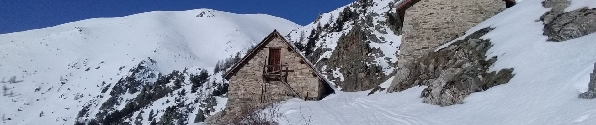
Après une montée au dernier parking monter dans le couloir et descendre au vacherie et plus en traversée. monter au sommet. Descente idem
Randonnée longue
Localisation
Commentaires
Randonnées à proximité
![Randonnée Marche Valdeblore - pepoiri - Photo](https://media.geolcdn.com/t/375/260/8ca18259-e53b-4625-8dc3-3afb9e53eb6b.jpg&format=jpg&maxdim=2)
![Marche Marche](https://static1.geolcdn.com/sitytour/trail-icons/101.png)
Marche
![](/images/other/stat-length.png)
![](https://static1.geolcdn.com/siteimages/upload/files/16400158638029165_repeat_loop_refresh_sync_direction_icon.png)
![Randonnée Marche Venanson - La Malouna - Photo](https://media.geolcdn.com/t/375/260/ext.jpg?maxdim=2&url=https%3A%2F%2Fservices.sitytrail.com%2FGeolivesWS%2FDownloadMedia.ashx%3FTrailID%3D405887%26Media%3Dfix__20150409152656.jpg)
![Marche Marche](https://static1.geolcdn.com/sitytour/trail-icons/101.png)
Marche
![](/images/other/stat-length.png)
![](https://static1.geolcdn.com/siteimages/upload/files/16400158638029165_repeat_loop_refresh_sync_direction_icon.png)
![Randonnée A pied Rimplas - Circuit de la Couletta - Photo](https://media.geolcdn.com/t/375/260/59146d83-b1b2-4140-8e5a-20a1c88ff012.jpeg&format=jpg&maxdim=2)
![A pied A pied](https://static1.geolcdn.com/sitytour/trail-icons/100.png)
A pied
![](/images/other/stat-length.png)
![](https://static1.geolcdn.com/siteimages/upload/files/16400158638029165_repeat_loop_refresh_sync_direction_icon.png)
![Randonnée A pied Valdeblore - Le Caïre Gros - Photo](https://media.geolcdn.com/t/375/260/3c6df4dd-1089-48da-8830-4c0973863251.jpeg&format=jpg&maxdim=2)
![A pied A pied](https://static1.geolcdn.com/sitytour/trail-icons/100.png)
A pied
![](/images/other/stat-length.png)
![](https://static1.geolcdn.com/siteimages/upload/files/16400158638029165_repeat_loop_refresh_sync_direction_icon.png)
![Randonnée A pied Venanson - Circuit du Conquet - Photo](https://media.geolcdn.com/t/375/260/e58595d6-e9ca-4e12-a313-f11c5e4c7d45.jpeg&format=jpg&maxdim=2)
![A pied A pied](https://static1.geolcdn.com/sitytour/trail-icons/100.png)
A pied
![](/images/other/stat-length.png)
![](https://static1.geolcdn.com/siteimages/upload/files/16400158638029165_repeat_loop_refresh_sync_direction_icon.png)
![Randonnée Marche Valdeblore - Les Lacs des Millefonts (Variante) - Photo](https://media.geolcdn.com/t/375/260/9ec3a33c-746a-4f95-a3bf-1bc95c27318a.jpg&format=jpg&maxdim=2)
![Marche Marche](https://static1.geolcdn.com/sitytour/trail-icons/101.png)
Marche
![](/images/other/stat-length.png)
![](https://static1.geolcdn.com/siteimages/upload/files/16400158638029165_repeat_loop_refresh_sync_direction_icon.png)
![Randonnée Ski de randonnée Valdeblore - Pèpoiri et Petoumier - Photo](https://media.geolcdn.com/t/375/260/b5f7f954-f6d6-45d0-b44a-3f93e1cb0060.jpg&format=jpg&maxdim=2)
![Ski de randonnée Ski de randonnée](https://static1.geolcdn.com/sitytour/trail-icons/503.png)
Ski de randonnée
![](/images/other/stat-length.png)
![](https://static1.geolcdn.com/siteimages/upload/files/16400158638029165_repeat_loop_refresh_sync_direction_icon.png)
![Randonnée Ski de randonnée Valdeblore - Mont Petoumier. Mont Pépoiri - Photo](https://media.geolcdn.com/t/375/260/ea867d2d-df72-4518-a830-624c286291ff.jpg&format=jpg&maxdim=2)
![Ski de randonnée Ski de randonnée](https://static1.geolcdn.com/sitytour/trail-icons/503.png)
Ski de randonnée
![](/images/other/stat-length.png)
![](https://static1.geolcdn.com/siteimages/upload/files/16400158638029165_repeat_loop_refresh_sync_direction_icon.png)
![Randonnée Marche Valdeblore - Lacs des Millefonts - Photo](https://media.geolcdn.com/t/375/260/4d35e3ed-d6f9-44a4-867a-ef4c4b385713.jpg&format=jpg&maxdim=2)
![Marche Marche](https://static1.geolcdn.com/sitytour/trail-icons/101.png)
Marche
![](/images/other/stat-length.png)
![](https://static1.geolcdn.com/siteimages/upload/files/16400158638029165_repeat_loop_refresh_sync_direction_icon.png)