![](/images/other/stat-length.png)
![Randonnée Marche La Asomada - la Asomada - la Geria - Montana de Guardilama - Photo](https://media.geolcdn.com/t/1900/400/a40db8e8-51bd-4bdb-86cb-b0ae83ea96d6.jpg&format=pjpeg&maxdim=2)
la Asomada - la Geria - Montana de Guardilama
mikaou.t
Utilisateur
![Longueur](/images/other/stat-length.png)
![Altitude max](https://static1.geolcdn.com/siteimages/upload/files/1508320355ic_sort_altitude_max_24dp.png)
![Dénivelé positif](https://static1.geolcdn.com/siteimages/upload/files/1508320355ic_sort_den_pos_24dp.png)
![Km-Effort](/images/other/stat-length.png)
![Altitude min](https://static1.geolcdn.com/siteimages/upload/files/1508320355ic_sort_altitude_min_24dp.png)
![Dénivelé négatif](https://static1.geolcdn.com/siteimages/upload/files/1508320355ic_sort_den_neg_24dp.png)
![Boucle](https://static1.geolcdn.com/siteimages/upload/files/16400158638029165_repeat_loop_refresh_sync_direction_icon.png)
![Marche](https://static1.geolcdn.com/sitytour/trail-icons/101.png)
2h30
Difficulté : Moyen
![Scannez ce code QR pour ouvrir la randonnée dans l'application SityTrail](https://capi.geolives.com/qq0zvz2zws4bq2lad0pu/sitytour/trails/2291719/qr.png?size=200)
Application GPS de randonnée GRATUITE
À propos
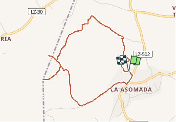
Randonnée Marche de 6,2 km à découvrir à Îles Canaries, Las Palmas. Cette randonnée est proposée par mikaou.t.
Description
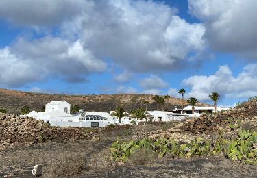
Départ de La Asomada. Peu après le départ, un petit mur barre le chemin, le contourner pour poursuivre la randonnée.
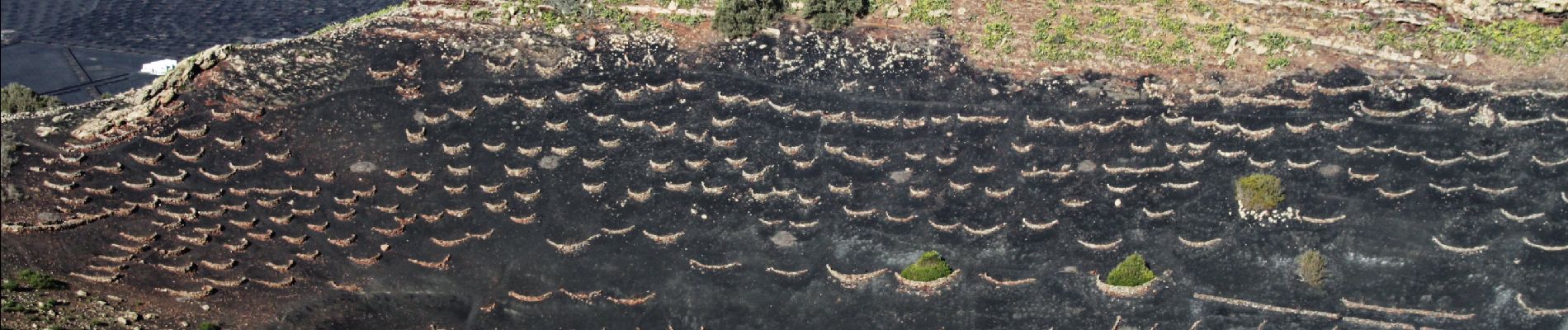
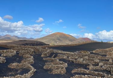
Plus loin, traverser les vignes de la Geria en suivant un sentier balisé.
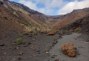
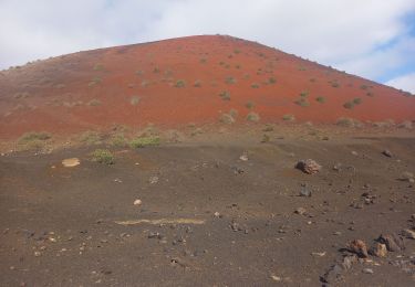
Arrivé au pied de la Montana de Guardilama, monter sur le bord droit du cratère pour admirer les vignes qui se trouvent à l'intérieur.
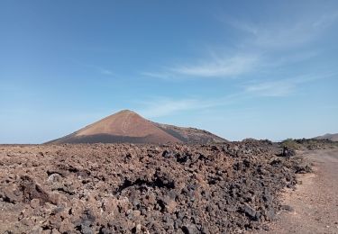
Redescendre et prendre le sentier juste en face afin de monter au sommet de la Montana à 603m d'altitude.
Du sommet la vue est absolument superbe sur toutes les vignes de la Geria et sur Lanzarote. L'un des meilleurs points de vues de l'ile.
Redescendre et prendre, à droite, un sentier qui passe au dessus des vignes afin de rejoindre le chemin qui retourne à la Asomada.
Attention : Par grand vent la montée au sommet peut être très délicate.
Localisation
Commentaires
Randonnées à proximité
![Randonnée Marche Tinajo - Caldera de los Cuervos 18.10.24 - Photo](https://media.geolcdn.com/t/375/260/b352200b-c8ab-4604-88dc-5b0a7a835ead.jpg&format=jpg&maxdim=2)
![Marche Marche](https://static1.geolcdn.com/sitytour/trail-icons/101.png)
Marche
![](/images/other/stat-length.png)
![](https://static1.geolcdn.com/siteimages/upload/files/16400158638029165_repeat_loop_refresh_sync_direction_icon.png)
![Randonnée Marche Tinajo - volcan Lanzarote - Photo](https://media.geolcdn.com/t/375/260/638d87b1-385e-4f51-ac2f-789cbbe7a500.jpg&format=jpg&maxdim=2)
![Marche Marche](https://static1.geolcdn.com/sitytour/trail-icons/101.png)
Marche
![](/images/other/stat-length.png)
![](https://static1.geolcdn.com/siteimages/upload/files/16400158638029165_repeat_loop_refresh_sync_direction_icon.png)
![Randonnée Marche Tinajo - Montaña Colorada 18.10.24 - Photo](https://media.geolcdn.com/t/375/260/46c79c3e-72ae-4ffe-ad2a-5c5df59c166c.jpg&format=jpg&maxdim=2)
![Marche Marche](https://static1.geolcdn.com/sitytour/trail-icons/101.png)
Marche
![](/images/other/stat-length.png)
![](https://static1.geolcdn.com/siteimages/upload/files/16400158638029165_repeat_loop_refresh_sync_direction_icon.png)
![Randonnée Marche Tías - Lanzarote- autour de Conil par le haut - Photo](https://media.geolcdn.com/t/375/260/8f04a3d2-0794-4a39-940e-13b79d54fbd7.jpg&format=jpg&maxdim=2)
![Marche Marche](https://static1.geolcdn.com/sitytour/trail-icons/101.png)
Marche
![](/images/other/stat-length.png)
![](https://static1.geolcdn.com/siteimages/upload/files/16400158638029165_repeat_loop_refresh_sync_direction_icon.png)
![Randonnée Marche Tías - LZ4 - Lanzarote 2 - Photo](https://media.geolcdn.com/t/375/260/1647facf-eedd-4713-a3c6-df042040e1d4.jpg&format=jpg&maxdim=2)
![Marche Marche](https://static1.geolcdn.com/sitytour/trail-icons/101.png)
Marche
![](/images/other/stat-length.png)
![](https://static1.geolcdn.com/siteimages/upload/files/16400158638029165_repeat_loop_refresh_sync_direction_icon.png)
![Randonnée Marche Tías - Lanzarote 05 du 21 10.2022 - Photo](https://media.geolcdn.com/t/375/260/ext.jpg?maxdim=2&url=https%3A%2F%2Fstatic1.geolcdn.com%2Fsiteimages%2Fupload%2Ffiles%2F1553511878bg_sport_marche.png)
![Marche Marche](https://static1.geolcdn.com/sitytour/trail-icons/101.png)
Marche
![](/images/other/stat-length.png)
![](https://static1.geolcdn.com/siteimages/upload/files/16400158638029165_repeat_loop_refresh_sync_direction_icon.png)
![Randonnée Autre activité Tías - gffgh - Photo](https://media.geolcdn.com/t/375/260/ext.jpg?maxdim=2&url=https%3A%2F%2Fstatic1.geolcdn.com%2Fsiteimages%2Fupload%2Ffiles%2F1545311037marcheuse_200dpi.jpg)
![Autre activité Autre activité](https://static1.geolcdn.com/sitytour/trail-icons/900.png)
Autre activité
![](/images/other/stat-length.png)
![](https://static1.geolcdn.com/siteimages/upload/files/16400158638029165_repeat_loop_refresh_sync_direction_icon.png)
![Randonnée Marche Tías - Lanzarote 6 - Photo](https://media.geolcdn.com/t/375/260/ext.jpg?maxdim=2&url=https%3A%2F%2Fstatic1.geolcdn.com%2Fsiteimages%2Fupload%2Ffiles%2F1553511878bg_sport_marche.png)
![Marche Marche](https://static1.geolcdn.com/sitytour/trail-icons/101.png)
Marche
![](/images/other/stat-length.png)
![](https://static1.geolcdn.com/siteimages/upload/files/16400158638029165_repeat_loop_refresh_sync_direction_icon.png)
![Randonnée Marche Tías - Lanzarote - autour de Conil (petit tour) - Photo](https://media.geolcdn.com/t/375/260/05c90646-c86d-481e-b9c2-07d1c48dac99.jpg&format=jpg&maxdim=2)
![Marche Marche](https://static1.geolcdn.com/sitytour/trail-icons/101.png)
Marche
![](/images/other/stat-length.png)
![](https://static1.geolcdn.com/siteimages/upload/files/16400158638029165_repeat_loop_refresh_sync_direction_icon.png)
Jolie randonnée qui permet de bien voir la culture de la vigne. Beau cratère aussi, rando faite avec un enfant de 6 ans.