![](/images/other/stat-length.png)
![Randonnée Marche Barentin - Autour du Centre Commercial - Photo](https://media.geolcdn.com/t/1900/400/ext.pjpeg?maxdim=2&url=https%3A%2F%2Fstatic1.geolcdn.com%2Fsiteimages%2Fupload%2Ffiles%2F1553511878bg_sport_marche.png)
Autour du Centre Commercial
BOUSSOLE ET SAC A DOS
Club Rando Saint-Paër
![Longueur](/images/other/stat-length.png)
Longueur
11,8 km
![Altitude max](https://static1.geolcdn.com/siteimages/upload/files/1508320355ic_sort_altitude_max_24dp.png)
Altitude max
132 m
![Dénivelé positif](https://static1.geolcdn.com/siteimages/upload/files/1508320355ic_sort_den_pos_24dp.png)
Dénivelé positif
128 m
![Km-Effort](/images/other/stat-length.png)
Km-Effort
13,5 km
![Altitude min](https://static1.geolcdn.com/siteimages/upload/files/1508320355ic_sort_altitude_min_24dp.png)
Altitude min
74 m
![Dénivelé négatif](https://static1.geolcdn.com/siteimages/upload/files/1508320355ic_sort_den_neg_24dp.png)
Dénivelé négatif
129 m
![Boucle](https://static1.geolcdn.com/siteimages/upload/files/16400158638029165_repeat_loop_refresh_sync_direction_icon.png)
Boucle
Oui
Date de création :
2019-12-17 10:40:39.254
Dernière modification :
2020-02-10 16:21:45.033
![Marche](https://static1.geolcdn.com/sitytour/trail-icons/101.png)
2h58
Difficulté : Facile
![Scannez ce code QR pour ouvrir la randonnée dans l'application SityTrail](https://capi.geolives.com/qq0zvz2zws4bq2lad0pu/sitytour/trails/2286414/qr.png?size=200)
Application GPS de randonnée GRATUITE
À propos
Randonnée Marche de 11,8 km à découvrir à Normandie, Seine-Maritime, Barentin. Cette randonnée est proposée par BOUSSOLE ET SAC A DOS.
Description
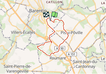
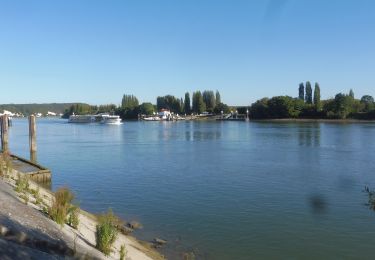
Rando assez facile de Barentin vers Pissy-Poville et Roumare
Localisation
Pays :
France
Région :
Normandie
Département/Province :
Seine-Maritime
Commune :
Barentin
Localité :
Unknown
Départ:(Dec)
Départ:(UTM)
352916 ; 5489250 (31U) N.
Commentaires
Randonnées à proximité
![Randonnée Marche Saint-Pierre-de-Varengeville - La voie verte au Paulu - Photo](https://media.geolcdn.com/t/375/260/ext.jpg?maxdim=2&url=https%3A%2F%2Fstatic1.geolcdn.com%2Fsiteimages%2Fupload%2Ffiles%2F1553511878bg_sport_marche.png)
![Marche Marche](https://static1.geolcdn.com/sitytour/trail-icons/101.png)
La voie verte au Paulu
Marche
Facile
(1)
Saint-Pierre-de-Varengeville,
Normandie,
Seine-Maritime,
France
![](/images/other/stat-length.png)
4,9 km | 6 km-effort
1h 18min
![](https://static1.geolcdn.com/siteimages/upload/files/16400158638029165_repeat_loop_refresh_sync_direction_icon.png)
Oui
![Randonnée Marche Saint-Pierre-de-Varengeville - Boucle du Paulu à Duclair - Photo](https://media.geolcdn.com/t/375/260/ext.jpg?maxdim=2&url=https%3A%2F%2Fstatic1.geolcdn.com%2Fsiteimages%2Fupload%2Ffiles%2F1553511878bg_sport_marche.png)
![Marche Marche](https://static1.geolcdn.com/sitytour/trail-icons/101.png)
Boucle du Paulu à Duclair
Marche
Difficile
(1)
Saint-Pierre-de-Varengeville,
Normandie,
Seine-Maritime,
France
![](/images/other/stat-length.png)
13,1 km | 16,2 km-effort
3h 29min
![](https://static1.geolcdn.com/siteimages/upload/files/16400158638029165_repeat_loop_refresh_sync_direction_icon.png)
Oui
![Randonnée Marche Saint-Pierre-de-Varengeville - Autour du Paulu - Photo](https://media.geolcdn.com/t/375/260/ext.jpg?maxdim=2&url=https%3A%2F%2Fstatic1.geolcdn.com%2Fsiteimages%2Fupload%2Ffiles%2F1553511878bg_sport_marche.png)
![Marche Marche](https://static1.geolcdn.com/sitytour/trail-icons/101.png)
Autour du Paulu
Marche
Facile
(1)
Saint-Pierre-de-Varengeville,
Normandie,
Seine-Maritime,
France
![](/images/other/stat-length.png)
4,2 km | 5,7 km-effort
1h 13min
![](https://static1.geolcdn.com/siteimages/upload/files/16400158638029165_repeat_loop_refresh_sync_direction_icon.png)
Oui
![Randonnée Marche Pavilly - 076-90-Pavilly / St Autreberthe 13.5km - Photo](https://media.geolcdn.com/t/375/260/a210e569-e658-42b2-bef9-eb8848a71140.jpg&format=jpg&maxdim=2)
![Marche Marche](https://static1.geolcdn.com/sitytour/trail-icons/101.png)
076-90-Pavilly / St Autreberthe 13.5km
Marche
Moyen
(1)
Pavilly,
Normandie,
Seine-Maritime,
France
![](/images/other/stat-length.png)
12 km | 15 km-effort
3h 23min
![](https://static1.geolcdn.com/siteimages/upload/files/16400158638029165_repeat_loop_refresh_sync_direction_icon.png)
Oui
![Randonnée Marche Saint-Pierre-de-Varengeville - 20240229-St Pierre de Varengeville - Photo](https://media.geolcdn.com/t/375/260/7008d225-ca6d-481f-b5f8-66a30a344d21.jpg&format=jpg&maxdim=2)
![Marche Marche](https://static1.geolcdn.com/sitytour/trail-icons/101.png)
20240229-St Pierre de Varengeville
Marche
Moyen
Saint-Pierre-de-Varengeville,
Normandie,
Seine-Maritime,
France
![](/images/other/stat-length.png)
12,5 km | 15 km-effort
3h 6min
![](https://static1.geolcdn.com/siteimages/upload/files/16400158638029165_repeat_loop_refresh_sync_direction_icon.png)
Oui
![Marche Marche](https://static1.geolcdn.com/sitytour/trail-icons/101.png)
20231026-Le Houlme
Marche
Moyen
Le Houlme,
Normandie,
Seine-Maritime,
France
![](/images/other/stat-length.png)
12 km | 15,7 km-effort
3h 29min
![](https://static1.geolcdn.com/siteimages/upload/files/16400158638029165_repeat_loop_refresh_sync_direction_icon.png)
Oui
![Marche Marche](https://static1.geolcdn.com/sitytour/trail-icons/101.png)
20221006-Barentin
Marche
Moyen
Barentin,
Normandie,
Seine-Maritime,
France
![](/images/other/stat-length.png)
13,7 km | 16,1 km-effort
3h 40min
![](https://static1.geolcdn.com/siteimages/upload/files/16400158638029165_repeat_loop_refresh_sync_direction_icon.png)
Oui
![Marche Marche](https://static1.geolcdn.com/sitytour/trail-icons/101.png)
20220203-Pavilly
Marche
Moyen
Pavilly,
Normandie,
Seine-Maritime,
France
![](/images/other/stat-length.png)
12,1 km | 15 km-effort
3h 36min
![](https://static1.geolcdn.com/siteimages/upload/files/16400158638029165_repeat_loop_refresh_sync_direction_icon.png)
Oui
![Marche Marche](https://static1.geolcdn.com/sitytour/trail-icons/101.png)
20211014-Duclair parcours de l'Anerie (ne pas publier)
Marche
Moyen
Saint-Pierre-de-Varengeville,
Normandie,
Seine-Maritime,
France
![](/images/other/stat-length.png)
13,1 km | 16,2 km-effort
3h 50min
![](https://static1.geolcdn.com/siteimages/upload/files/16400158638029165_repeat_loop_refresh_sync_direction_icon.png)
Oui