![](/images/other/stat-length.png)
![Randonnée Marche Jalhay - Baraque_Longfaye - Photo](https://media.geolcdn.com/t/1900/400/ext.pjpeg?maxdim=2&url=https%3A%2F%2Fstatic1.geolcdn.com%2Fsiteimages%2Fupload%2Ffiles%2F1553511878bg_sport_marche.png)
Baraque_Longfaye
jacques.moulin@hotmail.com
Utilisateur
![Longueur](/images/other/stat-length.png)
Longueur
16,8 km
![Altitude max](https://static1.geolcdn.com/siteimages/upload/files/1508320355ic_sort_altitude_max_24dp.png)
Altitude max
675 m
![Dénivelé positif](https://static1.geolcdn.com/siteimages/upload/files/1508320355ic_sort_den_pos_24dp.png)
Dénivelé positif
254 m
![Km-Effort](/images/other/stat-length.png)
Km-Effort
21 km
![Altitude min](https://static1.geolcdn.com/siteimages/upload/files/1508320355ic_sort_altitude_min_24dp.png)
Altitude min
440 m
![Dénivelé négatif](https://static1.geolcdn.com/siteimages/upload/files/1508320355ic_sort_den_neg_24dp.png)
Dénivelé négatif
378 m
![Boucle](https://static1.geolcdn.com/siteimages/upload/files/16400158638029165_repeat_loop_refresh_sync_direction_icon.png)
Boucle
Non
Date de création :
2014-12-10 00:00:00.0
Dernière modification :
2014-12-10 00:00:00.0
![Marche](https://static1.geolcdn.com/sitytour/trail-icons/101.png)
4h21
Difficulté : Moyen
![Scannez ce code QR pour ouvrir la randonnée dans l'application SityTrail](https://capi.geolives.com/qq0zvz2zws4bq2lad0pu/sitytour/trails/228541/qr.png?size=200)
Application GPS de randonnée GRATUITE
À propos
Randonnée Marche de 16,8 km à découvrir à Wallonie, Liège, Jalhay. Cette randonnée est proposée par jacques.moulin@hotmail.com.
Description
Au départ de la Baraque Michel, tour de la fagne wallonne,puis arrêt au Centre Nature, et descente du Ghaster, puis du Bayehon, en passant au moulin, et remontée du Pouhon et du Roannay avant de rejoindre Longfaye
Localisation
Pays :
Belgique
Région :
Wallonie
Département/Province :
Liège
Commune :
Jalhay
Localité :
Robertville
Départ:(Dec)
Départ:(UTM)
291834 ; 5600463 (32U) N.
Commentaires
Randonnées à proximité
![Randonnée Marche Waimes - RB-Lg-32_Botrange_via-racc-2 - Photo](https://media.geolcdn.com/t/375/260/ext.jpg?maxdim=2&url=https%3A%2F%2Fservices.sitytrail.com%2FGeolivesWS%2FDownloadMedia.ashx%3FTrailID%3D402164%26Media%3D5ad16311-48f2-4779-8b73-f8bce456ef00.jpg)
![Marche Marche](https://static1.geolcdn.com/sitytour/trail-icons/101.png)
RB-Lg-32_Botrange_via-racc-2
Marche
(6)
Waimes,
Wallonie,
Liège,
Belgique
![](/images/other/stat-length.png)
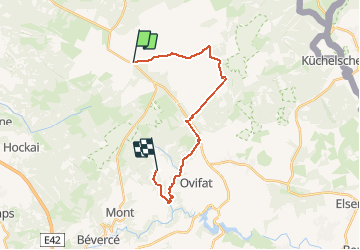
16,7 km | 22 km-effort
5h 4min
![](https://static1.geolcdn.com/siteimages/upload/files/16400158638029165_repeat_loop_refresh_sync_direction_icon.png)
Oui
![Randonnée Marche Waimes - RB-Lg-32_Botrange_via-racc-1 - Photo](https://media.geolcdn.com/t/375/260/ext.jpg?maxdim=2&url=https%3A%2F%2Fservices.sitytrail.com%2FGeolivesWS%2FDownloadMedia.ashx%3FTrailID%3D402158%26Media%3D5ad16311-48f2-4779-8b73-f8bce456ef00.jpg)
![Marche Marche](https://static1.geolcdn.com/sitytour/trail-icons/101.png)
RB-Lg-32_Botrange_via-racc-1
Marche
(7)
Waimes,
Wallonie,
Liège,
Belgique
![](/images/other/stat-length.png)
12,3 km | 15,7 km-effort
3h 34min
![](https://static1.geolcdn.com/siteimages/upload/files/16400158638029165_repeat_loop_refresh_sync_direction_icon.png)
Oui
![Randonnée Marche Waimes - RB-Lg-32_Botrange - Photo](https://media.geolcdn.com/t/375/260/ext.jpg?maxdim=2&url=https%3A%2F%2Fservices.sitytrail.com%2FGeolivesWS%2FDownloadMedia.ashx%3FTrailID%3D402156%26Media%3Dfd59a9ea-7261-4ddd-8af9-0290eaea98e9.jpg)
![Marche Marche](https://static1.geolcdn.com/sitytour/trail-icons/101.png)
![Randonnée Marche Waimes - Balade Peak Myrtille avec extension - restaurée - Photo](https://media.geolcdn.com/t/375/260/ext.jpg?maxdim=2&url=https%3A%2F%2Fstatic1.geolcdn.com%2Fsiteimages%2Fupload%2Ffiles%2F1553511878bg_sport_marche.png)
![Marche Marche](https://static1.geolcdn.com/sitytour/trail-icons/101.png)
Balade Peak Myrtille avec extension - restaurée
Marche
Moyen
(42)
Waimes,
Wallonie,
Liège,
Belgique
![](/images/other/stat-length.png)
4,9 km | 6 km-effort
1h 22min
![](https://static1.geolcdn.com/siteimages/upload/files/16400158638029165_repeat_loop_refresh_sync_direction_icon.png)
Oui
![Randonnée Marche Waimes - Balade Peak Myrtille - restaurée - Photo](https://media.geolcdn.com/t/375/260/ext.jpg?maxdim=2&url=https%3A%2F%2Fstatic1.geolcdn.com%2Fsiteimages%2Fupload%2Ffiles%2F1553511878bg_sport_marche.png)
![Marche Marche](https://static1.geolcdn.com/sitytour/trail-icons/101.png)
Balade Peak Myrtille - restaurée
Marche
Facile
(20)
Waimes,
Wallonie,
Liège,
Belgique
![](/images/other/stat-length.png)
2,7 km | 3,3 km-effort
45min
![](https://static1.geolcdn.com/siteimages/upload/files/16400158638029165_repeat_loop_refresh_sync_direction_icon.png)
Oui
![Randonnée Marche Waimes - Balade Peak Beer IPA (new) - Photo](https://media.geolcdn.com/t/375/260/69787633-7ca3-4264-9ec3-6547631cb468.png&format=jpg&maxdim=2)
![Marche Marche](https://static1.geolcdn.com/sitytour/trail-icons/101.png)
Balade Peak Beer IPA (new)
Marche
Moyen
(35)
Waimes,
Wallonie,
Liège,
Belgique
![](/images/other/stat-length.png)
9,7 km | 12 km-effort
2h 43min
![](https://static1.geolcdn.com/siteimages/upload/files/16400158638029165_repeat_loop_refresh_sync_direction_icon.png)
Oui
![Randonnée Marche Waimes - baraque Michel . botrange . baraque michel - Photo](https://media.geolcdn.com/t/375/260/c0a48186-0864-4f66-9ae4-72ca73dc2a0c.jpg&format=jpg&maxdim=2)
![Marche Marche](https://static1.geolcdn.com/sitytour/trail-icons/101.png)
baraque Michel . botrange . baraque michel
Marche
Très facile
(3)
Waimes,
Wallonie,
Liège,
Belgique
![](/images/other/stat-length.png)
8,9 km | 10,5 km-effort
3h 2min
![](https://static1.geolcdn.com/siteimages/upload/files/16400158638029165_repeat_loop_refresh_sync_direction_icon.png)
Oui
![Randonnée Marche Waimes - Prak beer brune - Photo](https://media.geolcdn.com/t/375/260/1004a3fe-d135-46da-92fc-7d19402e96c0.jpg&format=jpg&maxdim=2)
![Marche Marche](https://static1.geolcdn.com/sitytour/trail-icons/101.png)
Prak beer brune
Marche
Moyen
(2)
Waimes,
Wallonie,
Liège,
Belgique
![](/images/other/stat-length.png)
6,2 km | 8 km-effort
1h 38min
![](https://static1.geolcdn.com/siteimages/upload/files/16400158638029165_repeat_loop_refresh_sync_direction_icon.png)
Oui
![Randonnée Marche Waimes - autour de botrange - Photo](https://media.geolcdn.com/t/375/260/95f2bbdc-2e88-456f-b9aa-be0405f02c88.jpg&format=jpg&maxdim=2)
![Marche Marche](https://static1.geolcdn.com/sitytour/trail-icons/101.png)
autour de botrange
Marche
Moyen
(1)
Waimes,
Wallonie,
Liège,
Belgique
![](/images/other/stat-length.png)
20 km | 24 km-effort
5h 33min
![](https://static1.geolcdn.com/siteimages/upload/files/16400158638029165_repeat_loop_refresh_sync_direction_icon.png)
Oui