![](/images/other/stat-length.png)
![Randonnée Marche Theux - Charmille - Vert Buisson - La Reid - Photo](https://media.geolcdn.com/t/1900/400/d97e2ed8-c638-42f7-9ebb-11446133a7f1.jpg&format=pjpeg&maxdim=2)
Charmille - Vert Buisson - La Reid
flouzer
Utilisateur
![Longueur](/images/other/stat-length.png)
Longueur
6,2 km
![Altitude max](https://static1.geolcdn.com/siteimages/upload/files/1508320355ic_sort_altitude_max_24dp.png)
Altitude max
420 m
![Dénivelé positif](https://static1.geolcdn.com/siteimages/upload/files/1508320355ic_sort_den_pos_24dp.png)
Dénivelé positif
122 m
![Km-Effort](/images/other/stat-length.png)
Km-Effort
7,8 km
![Altitude min](https://static1.geolcdn.com/siteimages/upload/files/1508320355ic_sort_altitude_min_24dp.png)
Altitude min
298 m
![Dénivelé négatif](https://static1.geolcdn.com/siteimages/upload/files/1508320355ic_sort_den_neg_24dp.png)
Dénivelé négatif
126 m
![Boucle](https://static1.geolcdn.com/siteimages/upload/files/16400158638029165_repeat_loop_refresh_sync_direction_icon.png)
Boucle
Oui
Date de création :
2019-12-15 10:11:51.351
Dernière modification :
2019-12-15 11:59:15.961
![Marche](https://static1.geolcdn.com/sitytour/trail-icons/101.png)
1h40
Difficulté : Facile
![Scannez ce code QR pour ouvrir la randonnée dans l'application SityTrail](https://capi.geolives.com/qq0zvz2zws4bq2lad0pu/sitytour/trails/2285120/qr.png?size=200)
Application GPS de randonnée GRATUITE
À propos
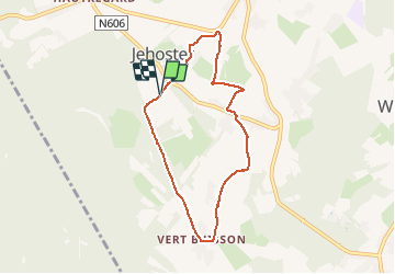
Randonnée Marche de 6,2 km à découvrir à Wallonie, Liège, Theux. Cette randonnée est proposée par flouzer.
Description
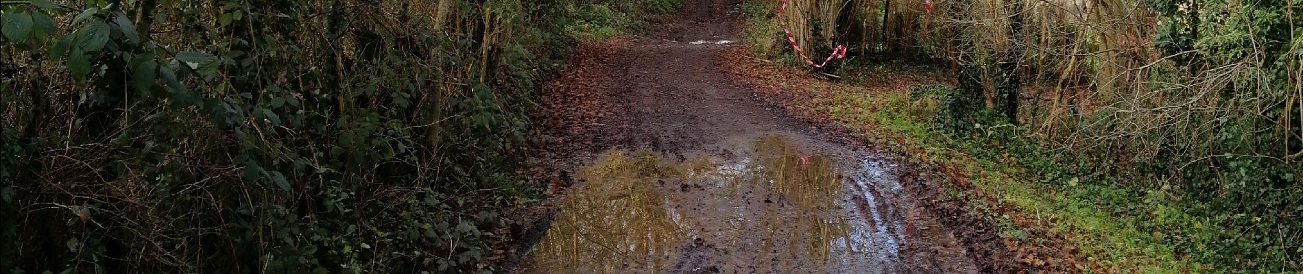
Après des périodes pluvieuses, prévoir des chaussures étanches pour un passage à gué qui est à quelques cm de profondeur avec le surplus de courant.
Localisation
Pays :
Belgique
Région :
Wallonie
Département/Province :
Liège
Commune :
Theux
Localité :
La Reid
Départ:(Dec)
Départ:(UTM)
696988 ; 5595480 (31U) N.
Commentaires
Randonnées à proximité
![Randonnée Marche Theux - RB-Lg-24_La-Reid_via-racc-1 - Photo](https://media.geolcdn.com/t/375/260/ext.jpg?maxdim=2&url=https%3A%2F%2Fservices.sitytrail.com%2FGeolivesWS%2FDownloadMedia.ashx%3FTrailID%3D400924%26Media%3De46f0d15-4872-47d2-9c6f-9e812d51cefb.jpg)
![Marche Marche](https://static1.geolcdn.com/sitytour/trail-icons/101.png)
RB-Lg-24_La-Reid_via-racc-1
Marche
(11)
Theux,
Wallonie,
Liège,
Belgique
![](/images/other/stat-length.png)
15,9 km | 21 km-effort
4h 50min
![](https://static1.geolcdn.com/siteimages/upload/files/16400158638029165_repeat_loop_refresh_sync_direction_icon.png)
Oui
![Randonnée Marche Theux - RB-Lg-24_La-Reid - Photo](https://media.geolcdn.com/t/375/260/ext.jpg?maxdim=2&url=https%3A%2F%2Fservices.sitytrail.com%2FGeolivesWS%2FDownloadMedia.ashx%3FTrailID%3D400922%26Media%3De46f0d15-4872-47d2-9c6f-9e812d51cefb.jpg)
![Marche Marche](https://static1.geolcdn.com/sitytour/trail-icons/101.png)
![Randonnée Marche Aywaille - RB-Lg-12_Remouchamps - Photo](https://media.geolcdn.com/t/375/260/ext.jpg?maxdim=2&url=https%3A%2F%2Fservices.sitytrail.com%2FGeolivesWS%2FDownloadMedia.ashx%3FTrailID%3D179570%26Media%3D1074d230-2da3-49cf-8210-a5f6b46fd870.jpg)
![Marche Marche](https://static1.geolcdn.com/sitytour/trail-icons/101.png)
RB-Lg-12_Remouchamps
Marche
Difficile
(9)
Aywaille,
Wallonie,
Liège,
Belgique
![](/images/other/stat-length.png)
24 km | 34 km-effort
7h 39min
![](https://static1.geolcdn.com/siteimages/upload/files/16400158638029165_repeat_loop_refresh_sync_direction_icon.png)
Oui
![Randonnée Marche Aywaille - Petite remontée du Ninglispo - Photo](https://media.geolcdn.com/t/375/260/ext.jpg?maxdim=2&url=https%3A%2F%2Fservices.sitytrail.com%2FGeolivesWS%2FDownloadMedia.ashx%3FTrailID%3D536482%26Media%3D20160311161707.jpg)
![Marche Marche](https://static1.geolcdn.com/sitytour/trail-icons/101.png)
Petite remontée du Ninglispo
Marche
Moyen
(9)
Aywaille,
Wallonie,
Liège,
Belgique
![](/images/other/stat-length.png)
6,7 km | 9,7 km-effort
2h 11min
![](https://static1.geolcdn.com/siteimages/upload/files/16400158638029165_repeat_loop_refresh_sync_direction_icon.png)
Oui
![Randonnée Marche Aywaille - RB-Lg-12_Remouchamps_via-racc-1 - Photo](https://media.geolcdn.com/t/375/260/ext.jpg?maxdim=2&url=https%3A%2F%2Fservices.sitytrail.com%2FGeolivesWS%2FDownloadMedia.ashx%3FTrailID%3D209433%26Media%3D1f1ef83d-c0c7-4521-b15a-02c5e9e7c1f1.jpg)
![Marche Marche](https://static1.geolcdn.com/sitytour/trail-icons/101.png)
RB-Lg-12_Remouchamps_via-racc-1
Marche
Difficile
(6)
Aywaille,
Wallonie,
Liège,
Belgique
![](/images/other/stat-length.png)
17 km | 25 km-effort
5h 46min
![](https://static1.geolcdn.com/siteimages/upload/files/16400158638029165_repeat_loop_refresh_sync_direction_icon.png)
Oui
![Marche Marche](https://static1.geolcdn.com/sitytour/trail-icons/101.png)
20220717 - HUWAO La Reid - 7 Km
Marche
Moyen
(2)
Theux,
Wallonie,
Liège,
Belgique
![](/images/other/stat-length.png)
7 km | 9,5 km-effort
2h 34min
![](https://static1.geolcdn.com/siteimages/upload/files/16400158638029165_repeat_loop_refresh_sync_direction_icon.png)
Oui
![Randonnée Marche Theux - vertbuisson . chefna . porallee . éolienne bronrome . vertbuisson - Photo](https://media.geolcdn.com/t/375/260/909f6ba2-ca5e-4f73-8360-60c62378ed9c.jpg&format=jpg&maxdim=2)
![Marche Marche](https://static1.geolcdn.com/sitytour/trail-icons/101.png)
vertbuisson . chefna . porallee . éolienne bronrome . vertbuisson
Marche
Très facile
(1)
Theux,
Wallonie,
Liège,
Belgique
![](/images/other/stat-length.png)
8,8 km | 10,4 km-effort
2h 10min
![](https://static1.geolcdn.com/siteimages/upload/files/16400158638029165_repeat_loop_refresh_sync_direction_icon.png)
Non
![Randonnée Marche Aywaille - RB-Lg-12_Remouchamps_via-racc-2 - Photo](https://media.geolcdn.com/t/375/260/ext.jpg?maxdim=2&url=https%3A%2F%2Fservices.sitytrail.com%2FGeolivesWS%2FDownloadMedia.ashx%3FTrailID%3D209432%26Media%3D1074d230-2da3-49cf-8210-a5f6b46fd870.jpg)
![Marche Marche](https://static1.geolcdn.com/sitytour/trail-icons/101.png)
RB-Lg-12_Remouchamps_via-racc-2
Marche
Difficile
(1)
Aywaille,
Wallonie,
Liège,
Belgique
![](/images/other/stat-length.png)
21 km | 31 km-effort
6h 42min
![](https://static1.geolcdn.com/siteimages/upload/files/16400158638029165_repeat_loop_refresh_sync_direction_icon.png)
Oui
![Randonnée Marche Theux - Chemin des Sources |étape n°9 LA REID – SPA - Photo](https://media.geolcdn.com/t/375/260/787ff85b-7dc6-41bf-a4d4-e52e973994d3.jpg&format=jpg&maxdim=2)
![Marche Marche](https://static1.geolcdn.com/sitytour/trail-icons/101.png)
Chemin des Sources |étape n°9 LA REID – SPA
Marche
Très difficile
(1)
Theux,
Wallonie,
Liège,
Belgique
![](/images/other/stat-length.png)
15,7 km | 21 km-effort
4h 46min
![](https://static1.geolcdn.com/siteimages/upload/files/16400158638029165_repeat_loop_refresh_sync_direction_icon.png)
Non