![](/images/other/stat-length.png)
![Randonnée Marche Villey-le-Sec - Villey le Sec - Photo](https://media.geolcdn.com/t/1900/400/ext.pjpeg?maxdim=2&url=https%3A%2F%2Fstatic1.geolcdn.com%2Fsiteimages%2Fupload%2Ffiles%2F1553511878bg_sport_marche.png)
Villey le Sec
joelclaudel
Utilisateur
![Longueur](/images/other/stat-length.png)
Longueur
11,9 km
![Altitude max](https://static1.geolcdn.com/siteimages/upload/files/1508320355ic_sort_altitude_max_24dp.png)
Altitude max
332 m
![Dénivelé positif](https://static1.geolcdn.com/siteimages/upload/files/1508320355ic_sort_den_pos_24dp.png)
Dénivelé positif
162 m
![Km-Effort](/images/other/stat-length.png)
Km-Effort
14,1 km
![Altitude min](https://static1.geolcdn.com/siteimages/upload/files/1508320355ic_sort_altitude_min_24dp.png)
Altitude min
203 m
![Dénivelé négatif](https://static1.geolcdn.com/siteimages/upload/files/1508320355ic_sort_den_neg_24dp.png)
Dénivelé négatif
161 m
![Boucle](https://static1.geolcdn.com/siteimages/upload/files/16400158638029165_repeat_loop_refresh_sync_direction_icon.png)
Boucle
Oui
Date de création :
2014-12-10 00:00:00.0
Dernière modification :
2014-12-10 00:00:00.0
![Marche](https://static1.geolcdn.com/sitytour/trail-icons/101.png)
3h07
Difficulté : Facile
![Scannez ce code QR pour ouvrir la randonnée dans l'application SityTrail](https://capi.geolives.com/qq0zvz2zws4bq2lad0pu/sitytour/trails/228337/qr.png?size=200)
Application GPS de randonnée GRATUITE
À propos
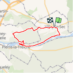
Randonnée Marche de 11,9 km à découvrir à Grand Est, Meurthe-et-Moselle, Villey-le-Sec. Cette randonnée est proposée par joelclaudel.
Description
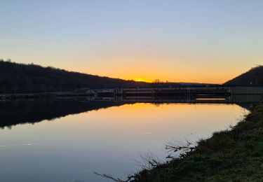
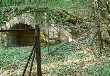
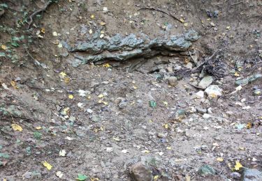
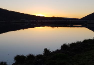
Descente vers le Moselle, barrage, Pierre la Treiche par la Moselle, Grottes Ste Reine,Fond de Chandelan, Forêt communale de Chaudeney,Fort de Villey le Sec
Localisation
Pays :
France
Région :
Grand Est
Département/Province :
Meurthe-et-Moselle
Commune :
Villey-le-Sec
Localité :
Unknown
Départ:(Dec)
Départ:(UTM)
719217 ; 5393891 (31U) N.
Commentaires
Randonnées à proximité
![Randonnée Cheval Villey-le-Sec - La Poudrière - Villey le Sec - Photo](https://media.geolcdn.com/t/375/260/ext.jpg?maxdim=2&url=https%3A%2F%2Fstatic1.geolcdn.com%2Fsiteimages%2Fupload%2Ffiles%2F1524743154cheval.jpg)
![Cheval Cheval](https://static1.geolcdn.com/sitytour/trail-icons/300.png)
La Poudrière - Villey le Sec
Cheval
Moyen
(1)
Villey-le-Sec,
Grand Est,
Meurthe-et-Moselle,
France
![](/images/other/stat-length.png)
8,6 km | 10,7 km-effort
1h 30min
![](https://static1.geolcdn.com/siteimages/upload/files/16400158638029165_repeat_loop_refresh_sync_direction_icon.png)
Oui
![Randonnée Marche Sexey-aux-Forges - Sexey Aux Forges - Photo](https://media.geolcdn.com/t/375/260/b5abff6f-2c34-417b-95da-67ff19f21fe9.jpg&format=jpg&maxdim=2)
![Marche Marche](https://static1.geolcdn.com/sitytour/trail-icons/101.png)
Sexey Aux Forges
Marche
Très difficile
Sexey-aux-Forges,
Grand Est,
Meurthe-et-Moselle,
France
![](/images/other/stat-length.png)
31 km | 38 km-effort
2h 38min
![](https://static1.geolcdn.com/siteimages/upload/files/16400158638029165_repeat_loop_refresh_sync_direction_icon.png)
Non
![Randonnée Marche Villey-le-Sec - Villey le sec - Les grottes - Le fort - Photo](https://media.geolcdn.com/t/375/260/174cce53-dd0d-4b92-98b6-4348d839bb57.jpg&format=jpg&maxdim=2)
![Marche Marche](https://static1.geolcdn.com/sitytour/trail-icons/101.png)
Villey le sec - Les grottes - Le fort
Marche
Moyen
Villey-le-Sec,
Grand Est,
Meurthe-et-Moselle,
France
![](/images/other/stat-length.png)
10,5 km | 12,5 km-effort
4h 30min
![](https://static1.geolcdn.com/siteimages/upload/files/16400158638029165_repeat_loop_refresh_sync_direction_icon.png)
Oui
![Randonnée Marche Toul - TOUL - LA CROIX D'ARGENT - Photo](https://media.geolcdn.com/t/375/260/e3f1b75b-7d57-4344-812a-03d7abcb3a24.jpg&format=jpg&maxdim=2)
![Marche Marche](https://static1.geolcdn.com/sitytour/trail-icons/101.png)
TOUL - LA CROIX D'ARGENT
Marche
Très facile
Toul,
Grand Est,
Meurthe-et-Moselle,
France
![](/images/other/stat-length.png)
13 km | 14,5 km-effort
3h 22min
![](https://static1.geolcdn.com/siteimages/upload/files/16400158638029165_repeat_loop_refresh_sync_direction_icon.png)
Oui
![Randonnée Marche Pierre-la-Treiche - pierre la triche grottes - Photo](https://media.geolcdn.com/t/375/260/ext.jpg?maxdim=2&url=https%3A%2F%2Fstatic1.geolcdn.com%2Fsiteimages%2Fupload%2Ffiles%2F1553511878bg_sport_marche.png)
![Marche Marche](https://static1.geolcdn.com/sitytour/trail-icons/101.png)
pierre la triche grottes
Marche
Très facile
(1)
Pierre-la-Treiche,
Grand Est,
Meurthe-et-Moselle,
France
![](/images/other/stat-length.png)
5,7 km | 6,5 km-effort
1h 22min
![](https://static1.geolcdn.com/siteimages/upload/files/16400158638029165_repeat_loop_refresh_sync_direction_icon.png)
Oui
![Randonnée Marche Pierre-la-Treiche - pierrre la treiche la deuille 1/5/2018 - Photo](https://media.geolcdn.com/t/375/260/ext.jpg?maxdim=2&url=https%3A%2F%2Fstatic1.geolcdn.com%2Fsiteimages%2Fupload%2Ffiles%2F1553511878bg_sport_marche.png)
![Marche Marche](https://static1.geolcdn.com/sitytour/trail-icons/101.png)
pierrre la treiche la deuille 1/5/2018
Marche
Très facile
(2)
Pierre-la-Treiche,
Grand Est,
Meurthe-et-Moselle,
France
![](/images/other/stat-length.png)
10,8 km | 13,1 km-effort
2h 57min
![](https://static1.geolcdn.com/siteimages/upload/files/16400158638029165_repeat_loop_refresh_sync_direction_icon.png)
Oui
![Randonnée Marche Villey-le-Sec - Villey le Sec Fort - Photo](https://media.geolcdn.com/t/375/260/ext.jpg?maxdim=2&url=https%3A%2F%2Fstatic1.geolcdn.com%2Fsiteimages%2Fupload%2Ffiles%2F1553511878bg_sport_marche.png)
![Marche Marche](https://static1.geolcdn.com/sitytour/trail-icons/101.png)
Villey le Sec Fort
Marche
Très facile
(1)
Villey-le-Sec,
Grand Est,
Meurthe-et-Moselle,
France
![](/images/other/stat-length.png)
6,1 km | 7,5 km-effort
1h 38min
![](https://static1.geolcdn.com/siteimages/upload/files/16400158638029165_repeat_loop_refresh_sync_direction_icon.png)
Oui
![Randonnée Marche Pierre-la-Treiche - pierre la treche - Photo](https://media.geolcdn.com/t/375/260/6cb3144c-b01a-4d7c-9c16-e77f5053a18f.jpg&format=jpg&maxdim=2)
![Marche Marche](https://static1.geolcdn.com/sitytour/trail-icons/101.png)
pierre la treche
Marche
Moyen
Pierre-la-Treiche,
Grand Est,
Meurthe-et-Moselle,
France
![](/images/other/stat-length.png)
12,1 km | 0 m-effort
3h 26min
![](https://static1.geolcdn.com/siteimages/upload/files/16400158638029165_repeat_loop_refresh_sync_direction_icon.png)
Oui
![Randonnée Marche Villey-le-Sec - PIERRE LA TREICHE - LES GROTTES ET LE FORT DE VILLEY LE SEC - Photo](https://media.geolcdn.com/t/375/260/8bac5130-764e-4dea-a415-b9d4f1cc2069.jpg&format=jpg&maxdim=2)
![Marche Marche](https://static1.geolcdn.com/sitytour/trail-icons/101.png)
PIERRE LA TREICHE - LES GROTTES ET LE FORT DE VILLEY LE SEC
Marche
Facile
Villey-le-Sec,
Grand Est,
Meurthe-et-Moselle,
France
![](/images/other/stat-length.png)
10,6 km | 12,7 km-effort
4h 26min
![](https://static1.geolcdn.com/siteimages/upload/files/16400158638029165_repeat_loop_refresh_sync_direction_icon.png)
Oui