![](/images/other/stat-length.png)
![Randonnée Marche La Robine-sur-Galabre - 20191209_Passerelle Bès_Lame Facibelle_Belvédère Pas d'oiseaux - Photo](https://media.geolcdn.com/t/1900/400/499248f1-1719-4629-8125-5476ea3fb7c8.jpg&format=pjpeg&maxdim=2)
20191209_Passerelle Bès_Lame Facibelle_Belvédère Pas d'oiseaux
PapouBertrand
Utilisateur
![Longueur](/images/other/stat-length.png)
![Altitude max](https://static1.geolcdn.com/siteimages/upload/files/1508320355ic_sort_altitude_max_24dp.png)
![Dénivelé positif](https://static1.geolcdn.com/siteimages/upload/files/1508320355ic_sort_den_pos_24dp.png)
![Km-Effort](/images/other/stat-length.png)
![Altitude min](https://static1.geolcdn.com/siteimages/upload/files/1508320355ic_sort_altitude_min_24dp.png)
![Dénivelé négatif](https://static1.geolcdn.com/siteimages/upload/files/1508320355ic_sort_den_neg_24dp.png)
![Boucle](https://static1.geolcdn.com/siteimages/upload/files/16400158638029165_repeat_loop_refresh_sync_direction_icon.png)
![Marche](https://static1.geolcdn.com/sitytour/trail-icons/101.png)
6h30
Difficulté : Difficile
![Scannez ce code QR pour ouvrir la randonnée dans l'application SityTrail](https://capi.geolives.com/qq0zvz2zws4bq2lad0pu/sitytour/trails/2282585/qr.png?size=200)
Application GPS de randonnée GRATUITE
À propos
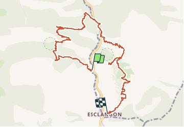
Randonnée Marche de 13,6 km à découvrir à Provence-Alpes-Côte d'Azur, Alpes-de-Haute-Provence, La Robine-sur-Galabre. Cette randonnée est proposée par PapouBertrand.
Description
Randonnée du CSA-Gap, Marche de 6h30, 14 km et 800 mètres de dénivelé à découvrir à Esclangon, ALPES-DE-HAUTE-PROVENCE, PROVENCE-ALPES-COTE D'AZUR.
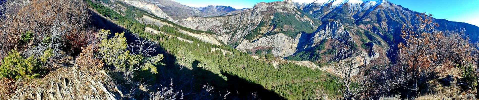
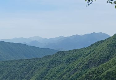
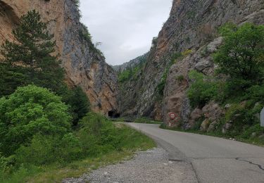
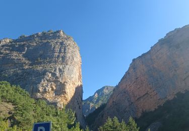
Départ de la passerelle du Bès, de magnifiques paysages sauvages et somptueux.
Il faut deux voitures ou revenir par la route à pied.
Localisation
Commentaires
Randonnées à proximité
![Randonnée Marche La Robine-sur-Galabre - LA ROBINE . Les Pharaons Au fil de l eau o m s - Photo](https://media.geolcdn.com/t/375/260/9537e3ba-9597-438e-8aca-d930b41df6e5.jpg&format=jpg&maxdim=2)
![Marche Marche](https://static1.geolcdn.com/sitytour/trail-icons/101.png)
Marche
![](/images/other/stat-length.png)
![](https://static1.geolcdn.com/siteimages/upload/files/16400158638029165_repeat_loop_refresh_sync_direction_icon.png)
![Randonnée Marche La Robine-sur-Galabre - LAMBERT mourre du barri o - Photo](https://media.geolcdn.com/t/375/260/ext.jpg?maxdim=2&url=https%3A%2F%2Fstatic1.geolcdn.com%2Fsiteimages%2Fupload%2Ffiles%2F1553511878bg_sport_marche.png)
![Marche Marche](https://static1.geolcdn.com/sitytour/trail-icons/101.png)
Marche
![](/images/other/stat-length.png)
![](https://static1.geolcdn.com/siteimages/upload/files/16400158638029165_repeat_loop_refresh_sync_direction_icon.png)
![Randonnée Marche La Robine-sur-Galabre - AINAC Col S Antoine . Feissal o s - Photo](https://media.geolcdn.com/t/375/260/a4a918fd-e34e-48ec-92ef-c8f2b718af60.jpg&format=jpg&maxdim=2)
![Marche Marche](https://static1.geolcdn.com/sitytour/trail-icons/101.png)
Marche
![](/images/other/stat-length.png)
![](https://static1.geolcdn.com/siteimages/upload/files/16400158638029165_repeat_loop_refresh_sync_direction_icon.png)
![Randonnée Marche Le Brusquet - LE MOUSTEIRET. Ruine Chalvet .Col de l Escuichiere . Le Villard o m s - Photo](https://media.geolcdn.com/t/375/260/309982b8-9ac7-4ddc-b526-513e7634afc1.jpg&format=jpg&maxdim=2)
![Marche Marche](https://static1.geolcdn.com/sitytour/trail-icons/101.png)
Marche
![](/images/other/stat-length.png)
![](https://static1.geolcdn.com/siteimages/upload/files/16400158638029165_repeat_loop_refresh_sync_direction_icon.png)
![Randonnée Marche Barles - Grande Cloche de Barles - Photo](https://media.geolcdn.com/t/375/260/ext.jpg?maxdim=2&url=https%3A%2F%2Fstatic1.geolcdn.com%2Fsiteimages%2Fupload%2Ffiles%2F1553511878bg_sport_marche.png)
![Marche Marche](https://static1.geolcdn.com/sitytour/trail-icons/101.png)
Marche
![](/images/other/stat-length.png)
![](https://static1.geolcdn.com/siteimages/upload/files/16400158638029165_repeat_loop_refresh_sync_direction_icon.png)
![Randonnée Marche La Javie - vélodrome esclangon 17kms 1049m - Photo](https://media.geolcdn.com/t/375/260/41a55657-54e1-4abd-8430-e74273f3ab02.jpg&format=jpg&maxdim=2)
![Marche Marche](https://static1.geolcdn.com/sitytour/trail-icons/101.png)
Marche
![](/images/other/stat-length.png)
![](https://static1.geolcdn.com/siteimages/upload/files/16400158638029165_repeat_loop_refresh_sync_direction_icon.png)
![Randonnée Marche La Javie - LA ROBINE , S Jean du Désert , lames Facibelle o l m s - Photo](https://media.geolcdn.com/t/375/260/eda89504-3de4-48b9-be88-0797dc1b7fea.jpg&format=jpg&maxdim=2)
![Marche Marche](https://static1.geolcdn.com/sitytour/trail-icons/101.png)
Marche
![](/images/other/stat-length.png)
![](https://static1.geolcdn.com/siteimages/upload/files/16400158638029165_repeat_loop_refresh_sync_direction_icon.png)
![Randonnée Marche Le Brusquet - LE BRUSQUET .Le tour des Blaches n - Photo](https://media.geolcdn.com/t/375/260/8f49b41b-86fe-49d3-8404-7ee7a8e8e571.jpg&format=jpg&maxdim=2)
![Marche Marche](https://static1.geolcdn.com/sitytour/trail-icons/101.png)
Marche
![](/images/other/stat-length.png)
![](https://static1.geolcdn.com/siteimages/upload/files/16400158638029165_repeat_loop_refresh_sync_direction_icon.png)
![Randonnée Marche La Javie - LA JAVIE, Esclangon , vieil Esclangon, le Velodrome , passerelle du Bes, Facibelle , Tanaron o n l s - Photo](https://media.geolcdn.com/t/375/260/2ecee787-cd9c-4f51-a9b1-aa7a09778d51.jpg&format=jpg&maxdim=2)
![Marche Marche](https://static1.geolcdn.com/sitytour/trail-icons/101.png)
Marche
![](/images/other/stat-length.png)
![](https://static1.geolcdn.com/siteimages/upload/files/16400158638029165_repeat_loop_refresh_sync_direction_icon.png)