Randonnée Marche Malmerspach - 68 - Mamlmerspach_Mehrbachel - Photo

68 - Mamlmerspach_Mehrbachel

 E.BURCK
E.BURCK

Utilisateur

© OpenStreetMap contributors
Longueur
Longueur
10,6 km
Altitude max
Altitude max
799 m
Dénivelé positif
Dénivelé positif
483 m
Km-Effort
Km-Effort  
17 km
Altitude min
Altitude min
391 m
Dénivelé négatif
Dénivelé négatif
484 m
Boucle
Boucle
Oui
Date de création :
2019-12-04 18:31:56.218
Dernière modification :
2019-12-18 14:17:35.588

(0 Avis)

Marche
Marche
3h30
Difficulté : Difficile

Scannez ce code QR pour ouvrir la randonnée dans l'application SityTrail

Application GPS de randonnée GRATUITE

Logo SityTrail SityTrail

IGN / Instituts géographiques

Télécharger SityTrail sur l'App Store Télécharger SityTrail sur Google Play

Logo SityTrail SityTrail World

Le monde est à vous

Télécharger SityTrail sur l'App Store Télécharger SityTrail sur Google Play Télécharger SityTrail sur Huawei AppGallery

À propos

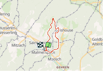
Randonnée Marche de 10,6 km à découvrir à Grand Est, Haut-Rhin, Malmerspach. Cette randonnée est proposée par E.BURCK.

Description

Une balade  vers le Mehrbächel. 460m de dénivelé sur 11 km.  (dont 420 m le matin)      
ACCÈS :
- par Thann, Bitschwiller, Willer, Moosch puis Malmerspach.
PARKING :
- parking 13 rue des Champs à Malmerspach.
47.866149, 7.036540 ou  
N 47°51'58", E 07°02'12"
RESTAURATION :      
Auberge du Mehrbächel.
Tél: 03 89 82 60 68

Profil altimétrique

Localisation

Pays :
France
Région :
Grand Est
Département/Province :
Haut-Rhin
Commune :
Malmerspach
Localité :
Unknown
Départ:(UTM)
353177 ; 5303288 (32T) N.

Randonnées à proximité

Randonnée A pied Bitschwiller-lès-Thann - Bitschwiller les Thann - Rehbrunnel - Abri du Becherkopf - Roche Albert - Photo
A pied
patrickbeyrath

A pied

Moyen
(1)
Bitschwiller-lès-Thann, Grand Est, Haut-Rhin, France
10,3 km | 16,4 km-effort
Inconnu
Oui
Randonnée Marche Soultz-Haut-Rhin - Mon tour des Vosges (4 jours) - Photo
Marche
annefrance70

Marche

Très difficile
Soultz-Haut-Rhin, Grand Est, Haut-Rhin, France
71 km | 113 km-effort
25h 38min
Oui
Randonnée Marche Ranspach - Rando des Marcheurs 20/07/2023 - Photo
Marche
boubou68

Marche

Très difficile
Ranspach, Grand Est, Haut-Rhin, France
23 km | 38 km-effort
5h 31min
Oui
Randonnée Marche Saint-Amarin - dimanche - Photo
Marche
Ninie38MD

Marche

Très difficile
(1)
Saint-Amarin, Grand Est, Haut-Rhin, France
19,4 km | 35 km-effort
7h 51min
Oui
Randonnée Marche Moosch - Moosch Haag - Photo
Marche
Estelle Handschin

Marche

Difficile
(1)
Moosch, Grand Est, Haut-Rhin, France
21 km | 0 m-effort
5h 27min
Oui
Randonnée V.T.C. Moosch - Lac de Kurt et jardin des merveilles  - Photo
V.T.C.
GUIDE
nadd73

V.T.C.

Facile
Moosch, Grand Est, Haut-Rhin, France
38 km | 45 km-effort
2h 24min
Oui
Randonnée Marche Moosch - Moos abri Faucon Crécerelle - Photo
Marche
ROPPJP

Marche

Très difficile
Moosch, Grand Est, Haut-Rhin, France
14,4 km | 24 km-effort
6h 32min
Oui
Randonnée Marche Saint-Amarin - Ranspach - Photo
Marche
ruelwitt

Marche

Difficile
(1)
Saint-Amarin, Grand Est, Haut-Rhin, France
11,3 km | 14,3 km-effort
3h 14min
Oui
Randonnée Marche Willer-sur-Thur - Willer sur Thur col du Haag  - Photo
Marche
gamille67

Marche

Moyen
Willer-sur-Thur, Grand Est, Haut-Rhin, France
29 km | 46 km-effort
6h 45min
Oui


Fermer
Mes abonnements