![](/images/other/stat-length.png)
![Randonnée Marche Fontenay-le-Fleury - Fontenay le fleury - Photo](https://media.geolcdn.com/t/1900/400/ext.pjpeg?maxdim=2&url=https%3A%2F%2Fstatic1.geolcdn.com%2Fsiteimages%2Fupload%2Ffiles%2F1553511878bg_sport_marche.png)
Fontenay le fleury
c.chehere
Utilisateur
![Longueur](/images/other/stat-length.png)
Longueur
18,2 km
![Altitude max](https://static1.geolcdn.com/siteimages/upload/files/1508320355ic_sort_altitude_max_24dp.png)
Altitude max
188 m
![Dénivelé positif](https://static1.geolcdn.com/siteimages/upload/files/1508320355ic_sort_den_pos_24dp.png)
Dénivelé positif
214 m
![Km-Effort](/images/other/stat-length.png)
Km-Effort
21 km
![Altitude min](https://static1.geolcdn.com/siteimages/upload/files/1508320355ic_sort_altitude_min_24dp.png)
Altitude min
99 m
![Dénivelé négatif](https://static1.geolcdn.com/siteimages/upload/files/1508320355ic_sort_den_neg_24dp.png)
Dénivelé négatif
201 m
![Boucle](https://static1.geolcdn.com/siteimages/upload/files/16400158638029165_repeat_loop_refresh_sync_direction_icon.png)
Boucle
Oui
Date de création :
2019-12-03 09:10:28.825
Dernière modification :
2019-12-06 10:57:28.796
![Marche](https://static1.geolcdn.com/sitytour/trail-icons/101.png)
5h15
Difficulté : Très facile
![Scannez ce code QR pour ouvrir la randonnée dans l'application SityTrail](https://capi.geolives.com/qq0zvz2zws4bq2lad0pu/sitytour/trails/2277566/qr.png?size=200)
Application GPS de randonnée GRATUITE
À propos
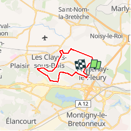
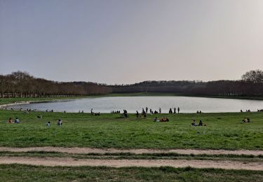
Randonnée Marche de 18,2 km à découvrir à Île-de-France, Yvelines, Fontenay-le-Fleury. Cette randonnée est proposée par c.chehere.
Description
Départ depuis le parking de le gare de Fontenay le fleury.
En grosse partie balisé, début de la rando sur des chemins d'exploitation agricole assez gras en hiver. La suite en forêt . Préférer les pistes forestière en hiver pour éviter la boue
Localisation
Pays :
France
Région :
Île-de-France
Département/Province :
Yvelines
Commune :
Fontenay-le-Fleury
Localité :
Unknown
Départ:(Dec)
Départ:(UTM)
429538 ; 5406599 (31U) N.
Commentaires
Randonnées à proximité
![Randonnée Marche Guyancourt - ALBG Etang val d'or, minière - Photo](https://media.geolcdn.com/t/375/260/ext.jpg?maxdim=2&url=https%3A%2F%2Fstatic1.geolcdn.com%2Fsiteimages%2Fupload%2Ffiles%2F1553511878bg_sport_marche.png)
![Marche Marche](https://static1.geolcdn.com/sitytour/trail-icons/101.png)
ALBG Etang val d'or, minière
Marche
Facile
(1)
Guyancourt,
Île-de-France,
Yvelines,
France
![](/images/other/stat-length.png)
13,1 km | 16,1 km-effort
3h 41min
![](https://static1.geolcdn.com/siteimages/upload/files/16400158638029165_repeat_loop_refresh_sync_direction_icon.png)
Oui
![Randonnée V.T.T. Saint-Cyr-l'École - 14102013 - Photo](https://media.geolcdn.com/t/375/260/ext.jpg?maxdim=2&url=https%3A%2F%2Fstatic1.geolcdn.com%2Fsiteimages%2Fupload%2Ffiles%2F1524743154velo.jpg)
![V.T.T. V.T.T.](https://static1.geolcdn.com/sitytour/trail-icons/202.png)
14102013
V.T.T.
Moyen
(1)
Saint-Cyr-l'École,
Île-de-France,
Yvelines,
France
![](/images/other/stat-length.png)
42 km | 50 km-effort
3h 11min
![](https://static1.geolcdn.com/siteimages/upload/files/16400158638029165_repeat_loop_refresh_sync_direction_icon.png)
Oui
![Randonnée V.T.T. Montigny-le-Bretonneux - Rando des renards 35k - Photo](https://media.geolcdn.com/t/375/260/ext.jpg?maxdim=2&url=https%3A%2F%2Fstatic1.geolcdn.com%2Fsiteimages%2Fupload%2Ffiles%2F1524743154velo.jpg)
![V.T.T. V.T.T.](https://static1.geolcdn.com/sitytour/trail-icons/202.png)
Rando des renards 35k
V.T.T.
Moyen
(1)
Montigny-le-Bretonneux,
Île-de-France,
Yvelines,
France
![](/images/other/stat-length.png)
38 km | 46 km-effort
2h 50min
![](https://static1.geolcdn.com/siteimages/upload/files/16400158638029165_repeat_loop_refresh_sync_direction_icon.png)
Oui
![Marche Marche](https://static1.geolcdn.com/sitytour/trail-icons/101.png)
2024-11-12-Rennemoulin-fontaine de Maltoute
Marche
Moyen
Rennemoulin,
Île-de-France,
Yvelines,
France
![](/images/other/stat-length.png)
6,6 km | 7,8 km-effort
1h 47min
![](https://static1.geolcdn.com/siteimages/upload/files/16400158638029165_repeat_loop_refresh_sync_direction_icon.png)
Oui
![Randonnée Marche Versailles - Tour du grand canal - Photo](https://media.geolcdn.com/t/375/260/44f1d875-f9d9-48f9-b6e9-6bb3ee1324d4.jpg&format=jpg&maxdim=2)
![Marche Marche](https://static1.geolcdn.com/sitytour/trail-icons/101.png)
Tour du grand canal
Marche
Moyen
Versailles,
Île-de-France,
Yvelines,
France
![](/images/other/stat-length.png)
6,6 km | 7,2 km-effort
1h 45min
![](https://static1.geolcdn.com/siteimages/upload/files/16400158638029165_repeat_loop_refresh_sync_direction_icon.png)
Oui
![Randonnée Marche Guyancourt - Etang de la Geneste - Photo](https://media.geolcdn.com/t/375/260/b0069325-c3ea-4e56-af3c-b7a82121bc33.jpg&format=jpg&maxdim=2)
![Marche Marche](https://static1.geolcdn.com/sitytour/trail-icons/101.png)
Etang de la Geneste
Marche
Facile
Guyancourt,
Île-de-France,
Yvelines,
France
![](/images/other/stat-length.png)
3,9 km | 4,9 km-effort
1h 11min
![](https://static1.geolcdn.com/siteimages/upload/files/16400158638029165_repeat_loop_refresh_sync_direction_icon.png)
Oui
![Randonnée Marche Versailles - Pièce d'eau des Suisses - Photo](https://media.geolcdn.com/t/375/260/0fec71f6-644a-4813-86e2-a3c43307f25b.jpg&format=jpg&maxdim=2)
![Marche Marche](https://static1.geolcdn.com/sitytour/trail-icons/101.png)
Pièce d'eau des Suisses
Marche
Facile
Versailles,
Île-de-France,
Yvelines,
France
![](/images/other/stat-length.png)
4,2 km | 5,2 km-effort
1h 12min
![](https://static1.geolcdn.com/siteimages/upload/files/16400158638029165_repeat_loop_refresh_sync_direction_icon.png)
Oui
![Randonnée V.T.T. Élancourt - VTT elancourt - Photo](https://media.geolcdn.com/t/375/260/7baccbc1-8d3f-4bc5-8bd1-9856d64ea15b.jpg&format=jpg&maxdim=2)
![V.T.T. V.T.T.](https://static1.geolcdn.com/sitytour/trail-icons/202.png)
VTT elancourt
V.T.T.
Facile
Élancourt,
Île-de-France,
Yvelines,
France
![](/images/other/stat-length.png)
26 km | 29 km-effort
2h 1min
![](https://static1.geolcdn.com/siteimages/upload/files/16400158638029165_repeat_loop_refresh_sync_direction_icon.png)
Oui
![Randonnée V.T.C. Fontenay-le-Fleury - Fontenay Versailles - Photo](https://media.geolcdn.com/t/375/260/819f1d88-4c93-4136-a66a-fc78c90ee4dd.jpg&format=jpg&maxdim=2)
![V.T.C. V.T.C.](https://static1.geolcdn.com/sitytour/trail-icons/203.png)
Fontenay Versailles
V.T.C.
Facile
(1)
Fontenay-le-Fleury,
Île-de-France,
Yvelines,
France
![](/images/other/stat-length.png)
20 km | 24 km-effort
1h 37min
![](https://static1.geolcdn.com/siteimages/upload/files/16400158638029165_repeat_loop_refresh_sync_direction_icon.png)
Oui