![](/images/other/stat-length.png)
![Randonnée Marche Gigors-et-Lozeron - Tour du rocher de St Supiere - Photo](https://media.geolcdn.com/t/1900/400/ext.pjpeg?maxdim=2&url=https%3A%2F%2Fstatic1.geolcdn.com%2Fsiteimages%2Fupload%2Ffiles%2F1553511878bg_sport_marche.png)
Tour du rocher de St Supiere
ajd26
Utilisateur
![Longueur](/images/other/stat-length.png)
Longueur
12,9 km
![Altitude max](https://static1.geolcdn.com/siteimages/upload/files/1508320355ic_sort_altitude_max_24dp.png)
Altitude max
912 m
![Dénivelé positif](https://static1.geolcdn.com/siteimages/upload/files/1508320355ic_sort_den_pos_24dp.png)
Dénivelé positif
544 m
![Km-Effort](/images/other/stat-length.png)
Km-Effort
20 km
![Altitude min](https://static1.geolcdn.com/siteimages/upload/files/1508320355ic_sort_altitude_min_24dp.png)
Altitude min
438 m
![Dénivelé négatif](https://static1.geolcdn.com/siteimages/upload/files/1508320355ic_sort_den_neg_24dp.png)
Dénivelé négatif
542 m
![Boucle](https://static1.geolcdn.com/siteimages/upload/files/16400158638029165_repeat_loop_refresh_sync_direction_icon.png)
Boucle
Oui
Date de création :
2019-11-26 08:40:32.0
Dernière modification :
2019-11-27 08:15:49.994
![Marche](https://static1.geolcdn.com/sitytour/trail-icons/101.png)
6h09
Difficulté : Facile
![Scannez ce code QR pour ouvrir la randonnée dans l'application SityTrail](https://capi.geolives.com/qq0zvz2zws4bq2lad0pu/sitytour/trails/2272960/qr.png?size=200)
Application GPS de randonnée GRATUITE
À propos
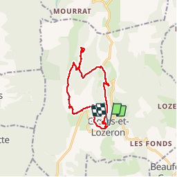
Randonnée Marche de 12,9 km à découvrir à Auvergne-Rhône-Alpes, Drôme, Gigors-et-Lozeron. Cette randonnée est proposée par ajd26.
Description
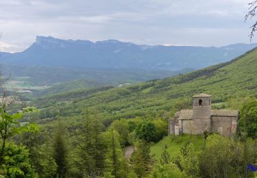
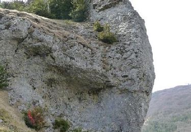
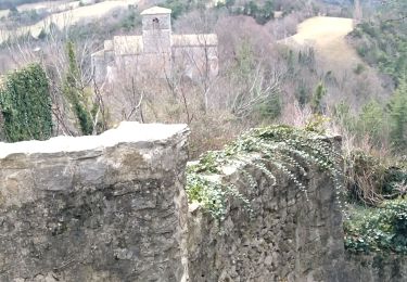
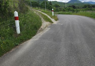
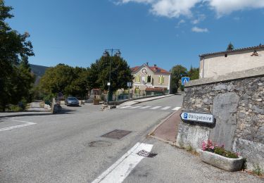
Départ de Gigors, montée aux ruines du château, aller retour pour essayer de voir la grotte par un sentier de crête et retour par la ferme de Boussiere suivre le balisage pour ne pas passer trop près de la ferme
Localisation
Pays :
France
Région :
Auvergne-Rhône-Alpes
Département/Province :
Drôme
Commune :
Gigors-et-Lozeron
Localité :
Unknown
Départ:(Dec)
Départ:(UTM)
666745 ; 4962204 (31T) N.
Commentaires
Randonnées à proximité
![Randonnée Marche Gigors-et-Lozeron - Gigors - Saint-Supière - Photo](https://media.geolcdn.com/t/375/260/7a89f170-854d-4e76-988d-32a2f6e427fd.jpg&format=jpg&maxdim=2)
![Marche Marche](https://static1.geolcdn.com/sitytour/trail-icons/101.png)
Gigors - Saint-Supière
Marche
Moyen
(1)
Gigors-et-Lozeron,
Auvergne-Rhône-Alpes,
Drôme,
France
![](/images/other/stat-length.png)
11 km | 18,1 km-effort
4h 0min
![](https://static1.geolcdn.com/siteimages/upload/files/16400158638029165_repeat_loop_refresh_sync_direction_icon.png)
Oui
![Randonnée Marche Gigors-et-Lozeron - St Supière et Savel à Gigors et Lozeron - Photo](https://media.geolcdn.com/t/375/260/ext.jpg?maxdim=2&url=https%3A%2F%2Fservices.sitytrail.com%2FGeolivesWS%2FDownloadMedia.ashx%3FTrailID%3D103208%26Media%3D5080_3.jpg)
![Marche Marche](https://static1.geolcdn.com/sitytour/trail-icons/101.png)
St Supière et Savel à Gigors et Lozeron
Marche
Difficile
(1)
Gigors-et-Lozeron,
Auvergne-Rhône-Alpes,
Drôme,
France
![](/images/other/stat-length.png)
11,2 km | 17,9 km-effort
4h 0min
![](https://static1.geolcdn.com/siteimages/upload/files/16400158638029165_repeat_loop_refresh_sync_direction_icon.png)
Oui
![Randonnée Marche Beaufort-sur-Gervanne - 26 gervanne druise plan de baix - Photo](https://media.geolcdn.com/t/375/260/cef04867-033e-4aa7-8c70-c5079a2317fe.jpg&format=jpg&maxdim=2)
![Marche Marche](https://static1.geolcdn.com/sitytour/trail-icons/101.png)
26 gervanne druise plan de baix
Marche
Moyen
Beaufort-sur-Gervanne,
Auvergne-Rhône-Alpes,
Drôme,
France
![](/images/other/stat-length.png)
16,8 km | 23 km-effort
7h 57min
![](https://static1.geolcdn.com/siteimages/upload/files/16400158638029165_repeat_loop_refresh_sync_direction_icon.png)
Oui
![Randonnée Marche Beaufort-sur-Gervanne - Beaufort St Pancrace 15km - Photo](https://media.geolcdn.com/t/375/260/ext.jpg?maxdim=2&url=https%3A%2F%2Fstatic1.geolcdn.com%2Fsiteimages%2Fupload%2Ffiles%2F1553511878bg_sport_marche.png)
![Marche Marche](https://static1.geolcdn.com/sitytour/trail-icons/101.png)
Beaufort St Pancrace 15km
Marche
Moyen
(1)
Beaufort-sur-Gervanne,
Auvergne-Rhône-Alpes,
Drôme,
France
![](/images/other/stat-length.png)
15 km | 21 km-effort
5h 0min
![](https://static1.geolcdn.com/siteimages/upload/files/16400158638029165_repeat_loop_refresh_sync_direction_icon.png)
Oui
![Randonnée Marche Gigors-et-Lozeron - 26 st supporte gigors - Photo](https://media.geolcdn.com/t/375/260/c169c5cd-1ed9-4b41-908c-c962ab944e47.jpg&format=jpg&maxdim=2)
![Marche Marche](https://static1.geolcdn.com/sitytour/trail-icons/101.png)
26 st supporte gigors
Marche
Moyen
Gigors-et-Lozeron,
Auvergne-Rhône-Alpes,
Drôme,
France
![](/images/other/stat-length.png)
16 km | 24 km-effort
5h 8min
![](https://static1.geolcdn.com/siteimages/upload/files/16400158638029165_repeat_loop_refresh_sync_direction_icon.png)
Oui
![Randonnée Marche Gigors-et-Lozeron - 26 gigors zel 24.01.25 - Photo](https://media.geolcdn.com/t/375/260/6d773d26-45d9-491c-869c-836081a35829.jpg&format=jpg&maxdim=2)
![Marche Marche](https://static1.geolcdn.com/sitytour/trail-icons/101.png)
26 gigors zel 24.01.25
Marche
Facile
Gigors-et-Lozeron,
Auvergne-Rhône-Alpes,
Drôme,
France
![](/images/other/stat-length.png)
13,1 km | 21 km-effort
5h 59min
![](https://static1.geolcdn.com/siteimages/upload/files/16400158638029165_repeat_loop_refresh_sync_direction_icon.png)
Oui
![Randonnée Marche Beaufort-sur-Gervanne - Beaufort - Gigors - Lozeron - Photo](https://media.geolcdn.com/t/375/260/8cacbdb2-dbdb-432d-83ba-9c60bb3f8279.jpg&format=jpg&maxdim=2)
![Marche Marche](https://static1.geolcdn.com/sitytour/trail-icons/101.png)
Beaufort - Gigors - Lozeron
Marche
Moyen
Beaufort-sur-Gervanne,
Auvergne-Rhône-Alpes,
Drôme,
France
![](/images/other/stat-length.png)
18,9 km | 28 km-effort
5h 0min
![](https://static1.geolcdn.com/siteimages/upload/files/16400158638029165_repeat_loop_refresh_sync_direction_icon.png)
Oui
![Randonnée Marche Beaufort-sur-Gervanne - BEAUFORT ET GERVANNE - Photo](https://media.geolcdn.com/t/375/260/9acf945f-4780-431b-bb4b-3d77cb822b0f.jpg&format=jpg&maxdim=2)
![Marche Marche](https://static1.geolcdn.com/sitytour/trail-icons/101.png)
BEAUFORT ET GERVANNE
Marche
Facile
Beaufort-sur-Gervanne,
Auvergne-Rhône-Alpes,
Drôme,
France
![](/images/other/stat-length.png)
36 km | 42 km-effort
4h 8min
![](https://static1.geolcdn.com/siteimages/upload/files/16400158638029165_repeat_loop_refresh_sync_direction_icon.png)
Non
![Randonnée Marche Plan-de-Baix - Canyon des Gueulards - Plateau du Vellan - Photo](https://media.geolcdn.com/t/375/260/df942d02-3843-4e15-b86a-2050f17fdf62.jpg&format=jpg&maxdim=2)
![Marche Marche](https://static1.geolcdn.com/sitytour/trail-icons/101.png)
Canyon des Gueulards - Plateau du Vellan
Marche
Moyen
Plan-de-Baix,
Auvergne-Rhône-Alpes,
Drôme,
France
![](/images/other/stat-length.png)
18,7 km | 28 km-effort
4h 55min
![](https://static1.geolcdn.com/siteimages/upload/files/16400158638029165_repeat_loop_refresh_sync_direction_icon.png)
Oui