


nicosie

bazannery
Utilisateur
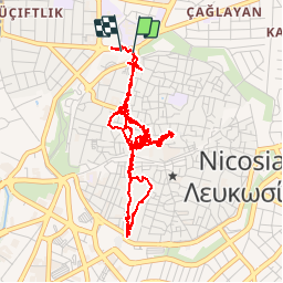

Longueur
7,9 km

Altitude max
158 m

Dénivelé positif
43 m
Km-Effort
8,5 km

Altitude min
141 m

Dénivelé négatif
48 m
Boucle
Oui
Date de création :
2019-11-26 10:15:51.431
Dernière modification :
2019-11-26 15:20:15.38
3h59
Difficulté : Très facile

Application GPS de randonnée GRATUITE
 SityTrail
IGN / Instituts géographiques
SityTrail World
Le monde est à vous
À propos
Randonnée Marche de 7,9 km à découvrir à Chypre. Cette randonnée est proposée par bazannery.
Localisation
Pays :
Chypre
Région :
Kuzey Kıbrıs
Département/Province :
Λευκωσία - Lefkoşa
Commune :
Λευκωσία - Lefkoşa
Localité :
Unknown
Départ:(Dec)
Départ:(UTM)
532924 ; 3893263 (36S) N.
Commentaires
Randonnées à proximité