Stoneham-et-Tewkesbury Québec 26 oct 2015 SityTrail > Randonnées > Outdoor > Canada > Québec > La Jacques-Cartier > Lac-Croche SityTrail > Randonnées > Outdoor > Canada > Québec > La Jacques-Cartier > Lac-Croche Stoneham-et-Tewkesbury Québec 26 oct 2015 TRIMAILLE Utilisateur 3D © OpenStreetMap contributors Longueur 15,9 km Altitude max 780 m Dénivelé positif 521 m Km-Effort 23 km Altitude min 280 m Dénivelé négatif 521 m Boucle Oui Date de création : 2019-11-25 11:57:25.578 Dernière modification : 2019-11-25 18:07:36.379 (0 Avis) Marche 4h48 Difficulté : Très difficile Application GPS de randonnée GRATUITE SityTrail IGN / Instituts géographiques SityTrail World Le monde est à vous À propos 
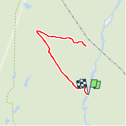
Randonnée Marche de 15,9 km à découvrir à Québec, La Jacques-Cartier, Lac-Croche. Cette randonnée est proposée par TRIMAILLE. Légendes | Plus de détails (PDF) Profil altimétrique Légendes > 15% 15% - 10% 10% - 5% à plat 5% - 10% 10% - 15% 15% - 30% > 30% Localisation Pays : Canada Région : Québec Département/Province : La Jacques-Cartier Commune : Lac-Croche Localité : Unknown Départ:(Dec) 47.315819 / -71.45619099999999 Départ:(UTM) 314374 ; 5243187 (19T) N. Commentaires Veuillez vous connecter pour laisser un commentaire ou une note Randonnées à proximité GUIDE Alizée.pee La Scotora Trail Marche Difficile Lac-Croche, Québec, La Jacques-Cartier, Canada 15,8 km | 23 km-effort 4h 46min Oui Tournan Le Scotora Marche Moyen Lac-Croche, Québec, La Jacques-Cartier, Canada 15,9 km | 23 km-effort 4h 51min Oui DaVinci Rivière Jacques Cartier Canoë - kayak Moyen Lac-Croche, Québec, La Jacques-Cartier, Canada 25 km | 28 km-effort 4h 15min Non