![](/images/other/stat-length.png)
![Randonnée Marche Belœil - Wapi - Promenade du Château de Beloeil - 50 - Photo](https://media.geolcdn.com/t/1900/400/4c298b86-7514-4b1d-a961-74a36b7c93f3.jpg&format=pjpeg&maxdim=2)
Wapi - Promenade du Château de Beloeil - 50
rfnet
Utilisateur
![Longueur](/images/other/stat-length.png)
Longueur
6,4 km
![Altitude max](https://static1.geolcdn.com/siteimages/upload/files/1508320355ic_sort_altitude_max_24dp.png)
Altitude max
77 m
![Dénivelé positif](https://static1.geolcdn.com/siteimages/upload/files/1508320355ic_sort_den_pos_24dp.png)
Dénivelé positif
49 m
![Km-Effort](/images/other/stat-length.png)
Km-Effort
7,1 km
![Altitude min](https://static1.geolcdn.com/siteimages/upload/files/1508320355ic_sort_altitude_min_24dp.png)
Altitude min
52 m
![Dénivelé négatif](https://static1.geolcdn.com/siteimages/upload/files/1508320355ic_sort_den_neg_24dp.png)
Dénivelé négatif
49 m
![Boucle](https://static1.geolcdn.com/siteimages/upload/files/16400158638029165_repeat_loop_refresh_sync_direction_icon.png)
Boucle
Oui
Date de création :
2019-11-17 14:29:43.349
Dernière modification :
2019-11-18 09:57:45.48
![Marche](https://static1.geolcdn.com/sitytour/trail-icons/101.png)
1h38
Difficulté : Très facile
![Scannez ce code QR pour ouvrir la randonnée dans l'application SityTrail](https://capi.geolives.com/qq0zvz2zws4bq2lad0pu/sitytour/trails/2266544/qr.png?size=200)
Application GPS de randonnée GRATUITE
À propos
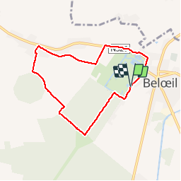
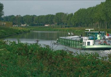
Randonnée Marche de 6,4 km à découvrir à Wallonie, Hainaut, Belœil. Cette randonnée est proposée par rfnet.
Description
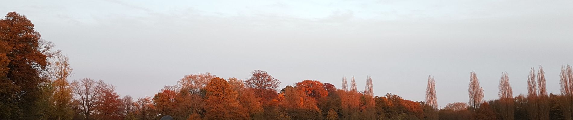
Une promenade plus qu'une randonnée autour du Château de Beloeil et la campagne avoisinante. Belle en automne, pas de difficulté particulière.
Localisation
Pays :
Belgique
Région :
Wallonie
Département/Province :
Hainaut
Commune :
Belœil
Localité :
Belil
Départ:(Dec)
Départ:(UTM)
551651 ; 5599725 (31U) N.
Commentaires
Randonnées à proximité
![Randonnée Marche Bernissart - RL-GG-08_Blaton_Erbisoeul - Photo](https://media.geolcdn.com/t/375/260/b5d305e0-4ee4-456e-bfc5-3d0771f79506.jpg&format=jpg&maxdim=2)
![Marche Marche](https://static1.geolcdn.com/sitytour/trail-icons/101.png)
RL-GG-08_Blaton_Erbisoeul
Marche
Très difficile
(2)
Bernissart,
Wallonie,
Hainaut,
Belgique
![](/images/other/stat-length.png)
26 km | 29 km-effort
6h 30min
![](https://static1.geolcdn.com/siteimages/upload/files/16400158638029165_repeat_loop_refresh_sync_direction_icon.png)
Non
![Randonnée Marche Belœil - Chemin de la fontaine bouillante - Photo](https://media.geolcdn.com/t/375/260/ext.jpg?maxdim=2&url=https%3A%2F%2Fservices.sitytrail.com%2FGeolivesWS%2FDownloadMedia.ashx%3FTrailID%3D202870%26Media%3D66f0b4d7-30a6-4305-b894-706a5e0388ba.jpg)
![Marche Marche](https://static1.geolcdn.com/sitytour/trail-icons/101.png)
Chemin de la fontaine bouillante
Marche
Très facile
(3)
Belœil,
Wallonie,
Hainaut,
Belgique
![](/images/other/stat-length.png)
3,6 km | 4,2 km-effort
Inconnu
![](https://static1.geolcdn.com/siteimages/upload/files/16400158638029165_repeat_loop_refresh_sync_direction_icon.png)
Oui
![Randonnée Marche Belœil - Beloeil - Circuit Natura 2000, des sites qui valent le détour - Ht06 - Photo](https://media.geolcdn.com/t/375/260/ext.jpg?maxdim=2&url=https%3A%2F%2Fservices.sitytrail.com%2FGeolivesWS%2FDownloadMedia.ashx%3FTrailID%3D356418%26Media%3D22e60fce-1fd7-4091-9907-7f7360a86d9d.JPG)
![Marche Marche](https://static1.geolcdn.com/sitytour/trail-icons/101.png)
Beloeil - Circuit Natura 2000, des sites qui valent le détour - Ht06
Marche
Très facile
(4)
Belœil,
Wallonie,
Hainaut,
Belgique
![](/images/other/stat-length.png)
3,5 km | 4 km-effort
51min
![](https://static1.geolcdn.com/siteimages/upload/files/16400158638029165_repeat_loop_refresh_sync_direction_icon.png)
Oui
![Randonnée Cheval Belœil - Boucle de Beloeil - Photo](https://media.geolcdn.com/t/375/260/ext.jpg?maxdim=2&url=https%3A%2F%2Fpivotmedia.tourismewallonie.be%2FANX-02-020D-00H9%2FANX-02-020D-00H9.jpg)
![Cheval Cheval](https://static1.geolcdn.com/sitytour/trail-icons/300.png)
Boucle de Beloeil
Cheval
Très facile
Belœil,
Wallonie,
Hainaut,
Belgique
![](/images/other/stat-length.png)
26 km | 30 km-effort
Inconnu
![](https://static1.geolcdn.com/siteimages/upload/files/16400158638029165_repeat_loop_refresh_sync_direction_icon.png)
Non
![Randonnée A pied Chièvres - La ronde des piedsentes - Photo](https://media.geolcdn.com/t/375/260/ext.jpg?maxdim=2&url=https%3A%2F%2Fpivotmedia.tourismewallonie.be%2FANX-02-03X8-001T%2FANX-02-03X8-001T.JPG)
![A pied A pied](https://static1.geolcdn.com/sitytour/trail-icons/100.png)
La ronde des piedsentes
A pied
Facile
Chièvres,
Wallonie,
Hainaut,
Belgique
![](/images/other/stat-length.png)
7,3 km | 7,8 km-effort
1h 46min
![](https://static1.geolcdn.com/siteimages/upload/files/16400158638029165_repeat_loop_refresh_sync_direction_icon.png)
Oui
![Randonnée A pied Belœil - Circuit de la Fontaine bouillante - Photo](https://media.geolcdn.com/t/375/260/ext.jpg?maxdim=2&url=https%3A%2F%2Fpivotmedia.tourismewallonie.be%2FANX-02-03MT-01JO%2FANX-02-03MT-01JO.JPG)
![A pied A pied](https://static1.geolcdn.com/sitytour/trail-icons/100.png)
Circuit de la Fontaine bouillante
A pied
Facile
Belœil,
Wallonie,
Hainaut,
Belgique
![](/images/other/stat-length.png)
3,8 km | 4,5 km-effort
1h 0min
![](https://static1.geolcdn.com/siteimages/upload/files/16400158638029165_repeat_loop_refresh_sync_direction_icon.png)
Oui
![Randonnée Marche Belœil - RB-Ha-15 - Beloeil - Via raccourci - Photo](https://media.geolcdn.com/t/375/260/ext.jpg?maxdim=2&url=https%3A%2F%2Fservices.sitytrail.com%2FGeolivesWS%2FDownloadMedia.ashx%3FTrailID%3D220190%26Media%3D8bc51c59-c4bb-4f2e-b648-ece9ca4b5290.jpg)
![Marche Marche](https://static1.geolcdn.com/sitytour/trail-icons/101.png)
RB-Ha-15 - Beloeil - Via raccourci
Marche
Difficile
Belœil,
Wallonie,
Hainaut,
Belgique
![](/images/other/stat-length.png)
15,7 km | 17,8 km-effort
4h 2min
![](https://static1.geolcdn.com/siteimages/upload/files/16400158638029165_repeat_loop_refresh_sync_direction_icon.png)
Oui
![Randonnée Marche Belœil - RB-Ha-15 - Beloeil - Photo](https://media.geolcdn.com/t/375/260/ext.jpg?maxdim=2&url=https%3A%2F%2Fservices.sitytrail.com%2FGeolivesWS%2FDownloadMedia.ashx%3FTrailID%3D179609%26Media%3D8bc51c59-c4bb-4f2e-b648-ece9ca4b5290.jpg)
![Marche Marche](https://static1.geolcdn.com/sitytour/trail-icons/101.png)
RB-Ha-15 - Beloeil
Marche
Très difficile
(2)
Belœil,
Wallonie,
Hainaut,
Belgique
![](/images/other/stat-length.png)
23 km | 26 km-effort
5h 48min
![](https://static1.geolcdn.com/siteimages/upload/files/16400158638029165_repeat_loop_refresh_sync_direction_icon.png)
Oui
![Randonnée Marche Chièvres - LADEUZE ( CHIEVRES ) _ Marche Fédérale _ HT _ 18/06/2023 - Photo](https://media.geolcdn.com/t/375/260/61ccc8f0-5506-417a-b16d-ce93c6423952.jpg&format=jpg&maxdim=2)
![Marche Marche](https://static1.geolcdn.com/sitytour/trail-icons/101.png)
LADEUZE ( CHIEVRES ) _ Marche Fédérale _ HT _ 18/06/2023
Marche
Moyen
Chièvres,
Wallonie,
Hainaut,
Belgique
![](/images/other/stat-length.png)
19,8 km | 21 km-effort
4h 42min
![](https://static1.geolcdn.com/siteimages/upload/files/16400158638029165_repeat_loop_refresh_sync_direction_icon.png)
Oui