![](/images/other/stat-length.png)
![Randonnée Marche Gourdon - Balcons du Loup Aller simple - Photo](https://media.geolcdn.com/t/1900/400/ext.pjpeg?maxdim=2&url=https%3A%2F%2Fstatic1.geolcdn.com%2Fsiteimages%2Fupload%2Ffiles%2F1553511878bg_sport_marche.png)
Balcons du Loup Aller simple
jmheydorff
Utilisateur
![Longueur](/images/other/stat-length.png)
Longueur
8,7 km
![Altitude max](https://static1.geolcdn.com/siteimages/upload/files/1508320355ic_sort_altitude_max_24dp.png)
Altitude max
606 m
![Dénivelé positif](https://static1.geolcdn.com/siteimages/upload/files/1508320355ic_sort_den_pos_24dp.png)
Dénivelé positif
596 m
![Km-Effort](/images/other/stat-length.png)
Km-Effort
15,7 km
![Altitude min](https://static1.geolcdn.com/siteimages/upload/files/1508320355ic_sort_altitude_min_24dp.png)
Altitude min
183 m
![Dénivelé négatif](https://static1.geolcdn.com/siteimages/upload/files/1508320355ic_sort_den_neg_24dp.png)
Dénivelé négatif
314 m
![Boucle](https://static1.geolcdn.com/siteimages/upload/files/16400158638029165_repeat_loop_refresh_sync_direction_icon.png)
Boucle
Non
Date de création :
2014-12-10 00:00:00.0
Dernière modification :
2014-12-10 00:00:00.0
![Marche](https://static1.geolcdn.com/sitytour/trail-icons/101.png)
4h20
Difficulté : Moyen
![Scannez ce code QR pour ouvrir la randonnée dans l'application SityTrail](https://capi.geolives.com/qq0zvz2zws4bq2lad0pu/sitytour/trails/226522/qr.png?size=200)
Application GPS de randonnée GRATUITE
À propos
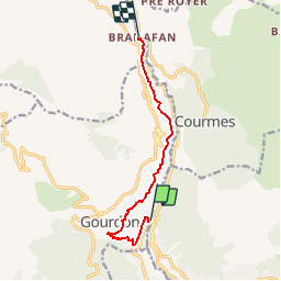
Randonnée Marche de 8,7 km à découvrir à Provence-Alpes-Côte d'Azur, Alpes-Maritimes, Gourdon. Cette randonnée est proposée par jmheydorff.
Description
9 kms 500m 3h00 à l'aller 2h30 au retour.
Pkg au Pont du Loup.
Aqueduc du foulon sur le GR 51, depuis Pont du Loup
Localisation
Pays :
France
Région :
Provence-Alpes-Côte d'Azur
Département/Province :
Alpes-Maritimes
Commune :
Gourdon
Localité :
Unknown
Départ:(Dec)
Départ:(UTM)
338243 ; 4842737 (32T) N.
Commentaires
Randonnées à proximité
![Randonnée Marche Gourdon - Plateau de Cavillore, la Forteresse - Gourdon - Photo](https://media.geolcdn.com/t/375/260/ext.jpg?maxdim=2&url=https%3A%2F%2Fservices.sitytrail.com%2FGeolivesWS%2FDownloadMedia.ashx%3FTrailID%3D214895%26Media%3D15446_1.jpg)
![Marche Marche](https://static1.geolcdn.com/sitytour/trail-icons/101.png)
Plateau de Cavillore, la Forteresse - Gourdon
Marche
Moyen
(3)
Gourdon,
Provence-Alpes-Côte d'Azur,
Alpes-Maritimes,
France
![](/images/other/stat-length.png)
7,2 km | 11,2 km-effort
2h 15min
![](https://static1.geolcdn.com/siteimages/upload/files/16400158638029165_repeat_loop_refresh_sync_direction_icon.png)
Oui
![Randonnée Marche Le Bar-sur-Loup - Le Bar sur Loup Gourdon Barre et plateau de Cavillore réel - Photo](https://media.geolcdn.com/t/375/260/c167fd77-8053-444f-a9c7-0c602a316e76.jpg&format=jpg&maxdim=2)
![Marche Marche](https://static1.geolcdn.com/sitytour/trail-icons/101.png)
Le Bar sur Loup Gourdon Barre et plateau de Cavillore réel
Marche
Très difficile
Le Bar-sur-Loup,
Provence-Alpes-Côte d'Azur,
Alpes-Maritimes,
France
![](/images/other/stat-length.png)
19,3 km | 32 km-effort
7h 19min
![](https://static1.geolcdn.com/siteimages/upload/files/16400158638029165_repeat_loop_refresh_sync_direction_icon.png)
Oui
![Randonnée Marche Le Bar-sur-Loup - rando - Photo](https://media.geolcdn.com/t/375/260/fa0ef731-2bd1-40ee-a714-99f05472c6fe.jpg&format=jpg&maxdim=2)
![Marche Marche](https://static1.geolcdn.com/sitytour/trail-icons/101.png)
rando
Marche
Très difficile
Le Bar-sur-Loup,
Provence-Alpes-Côte d'Azur,
Alpes-Maritimes,
France
![](/images/other/stat-length.png)
12,1 km | 21 km-effort
6h 9min
![](https://static1.geolcdn.com/siteimages/upload/files/16400158638029165_repeat_loop_refresh_sync_direction_icon.png)
Non
![Randonnée A pied Le Bar-sur-Loup - Circuit de la Malle - Photo](https://media.geolcdn.com/t/375/260/9cf230aa-9298-45ef-9b30-612a3965bbab.jpeg&format=jpg&maxdim=2)
![A pied A pied](https://static1.geolcdn.com/sitytour/trail-icons/100.png)
Circuit de la Malle
A pied
Difficile
Le Bar-sur-Loup,
Provence-Alpes-Côte d'Azur,
Alpes-Maritimes,
France
![](/images/other/stat-length.png)
22 km | 34 km-effort
7h 43min
![](https://static1.geolcdn.com/siteimages/upload/files/16400158638029165_repeat_loop_refresh_sync_direction_icon.png)
Oui
![Randonnée A pied Le Bar-sur-Loup - Circuit du Paradis - Photo](https://media.geolcdn.com/t/375/260/c599f589-6942-4b9f-bfea-287eb9516c31.jpeg&format=jpg&maxdim=2)
![A pied A pied](https://static1.geolcdn.com/sitytour/trail-icons/100.png)
Circuit du Paradis
A pied
Facile
Le Bar-sur-Loup,
Provence-Alpes-Côte d'Azur,
Alpes-Maritimes,
France
![](/images/other/stat-length.png)
8,1 km | 15 km-effort
3h 24min
![](https://static1.geolcdn.com/siteimages/upload/files/16400158638029165_repeat_loop_refresh_sync_direction_icon.png)
Oui
![Randonnée A pied Gourdon - Plateau de Cavillore - Photo](https://media.geolcdn.com/t/375/260/094c0018-0a4d-4f34-8879-15bc82519f15.jpeg&format=jpg&maxdim=2)
![A pied A pied](https://static1.geolcdn.com/sitytour/trail-icons/100.png)
Plateau de Cavillore
A pied
Facile
Gourdon,
Provence-Alpes-Côte d'Azur,
Alpes-Maritimes,
France
![](/images/other/stat-length.png)
5,9 km | 10 km-effort
2h 16min
![](https://static1.geolcdn.com/siteimages/upload/files/16400158638029165_repeat_loop_refresh_sync_direction_icon.png)
Oui
![Randonnée A pied Courmes - Plateau de Saint-Barnabé - Photo](https://media.geolcdn.com/t/375/260/e5884674-6345-4525-aa20-82da8aac2558.jpeg&format=jpg&maxdim=2)
![A pied A pied](https://static1.geolcdn.com/sitytour/trail-icons/100.png)
Plateau de Saint-Barnabé
A pied
Facile
Courmes,
Provence-Alpes-Côte d'Azur,
Alpes-Maritimes,
France
![](/images/other/stat-length.png)
6,6 km | 11,1 km-effort
2h 31min
![](https://static1.geolcdn.com/siteimages/upload/files/16400158638029165_repeat_loop_refresh_sync_direction_icon.png)
Oui
![Randonnée Marche Le Bar-sur-Loup - Aqueducs du Foulon et du loup - Photo](https://media.geolcdn.com/t/375/260/ext.jpg?maxdim=2&url=https%3A%2F%2Fstatic1.geolcdn.com%2Fsiteimages%2Fupload%2Ffiles%2F1553511878bg_sport_marche.png)
![Marche Marche](https://static1.geolcdn.com/sitytour/trail-icons/101.png)
Aqueducs du Foulon et du loup
Marche
Moyen
(1)
Le Bar-sur-Loup,
Provence-Alpes-Côte d'Azur,
Alpes-Maritimes,
France
![](/images/other/stat-length.png)
10,3 km | 18,6 km-effort
4h 12min
![](https://static1.geolcdn.com/siteimages/upload/files/16400158638029165_repeat_loop_refresh_sync_direction_icon.png)
Oui
![Randonnée Marche Gourdon - Forteresse Cavillore Gourdon - Photo](https://media.geolcdn.com/t/375/260/d86df71f-5380-4907-b859-38b5c90d8308.jpg&format=jpg&maxdim=2)
![Marche Marche](https://static1.geolcdn.com/sitytour/trail-icons/101.png)
Forteresse Cavillore Gourdon
Marche
Facile
Gourdon,
Provence-Alpes-Côte d'Azur,
Alpes-Maritimes,
France
![](/images/other/stat-length.png)
9,4 km | 14,9 km-effort
3h 23min
![](https://static1.geolcdn.com/siteimages/upload/files/16400158638029165_repeat_loop_refresh_sync_direction_icon.png)
Oui