Randonnée Marche Trois-Ponts - Autour de l'Amblève: épisode 8 autour de Trois-Ponts - Photo

Autour de l'Amblève: épisode 8 autour de Trois-Ponts

 phbindelle
phbindelle

Utilisateur

© OpenStreetMap contributors
Longueur
Longueur
14,9 km
Altitude max
Altitude max
442 m
Dénivelé positif
Dénivelé positif
523 m
Km-Effort
Km-Effort  
22 km
Altitude min
Altitude min
248 m
Dénivelé négatif
Dénivelé négatif
522 m
Boucle
Boucle
Oui
Date de création :
2019-11-12 12:44:46.392
Dernière modification :
2020-01-27 15:41:29.466

(0 Avis)

Marche
Marche
4h34
Difficulté : Très difficile

Scannez ce code QR pour ouvrir la randonnée dans l'application SityTrail

Application GPS de randonnée GRATUITE

Logo SityTrail SityTrail

IGN / Instituts géographiques

Télécharger SityTrail sur l'App Store Télécharger SityTrail sur Google Play

Logo SityTrail SityTrail World

Le monde est à vous

Télécharger SityTrail sur l'App Store Télécharger SityTrail sur Google Play Télécharger SityTrail sur Huawei AppGallery

À propos

Randonnée Marche de 14,9 km à découvrir à Wallonie, Liège, Trois-Ponts. Cette randonnée est proposée par phbindelle.

Description

Vallées de la Salm, le Bodeux et l'Amblève... découverte des alentours de Trois-Ponts

Profil altimétrique

Photos

Points d'intérêt

Point d'intérêt Trois-Ponts - Géocache tour de wallonie - Photo
phbindelle

Localisation

Pays :
Belgique
Région :
Wallonie
Département/Province :
Liège
Commune :
Trois-Ponts
Localité :
Wanne
Départ:(UTM)
704297 ; 5583580 (31U) N.

Randonnées à proximité

Randonnée Marche Trois-Ponts - RB-Lg-29_Wanne - Photo
Marche
PRO

Marche

(5)
Trois-Ponts, Wallonie, Liège, Belgique
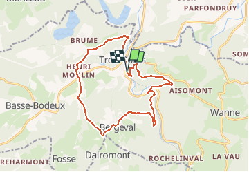
22 km | 29 km-effort
6h 41min
Oui
Randonnée Marche Trois-Ponts - RB-Lg-27_Trois-Ponts - Photo
Marche
PRO

Marche

(7)
Trois-Ponts, Wallonie, Liège, Belgique
23 km | 33 km-effort
7h 30min
Oui
Randonnée Marche Stoumont - RB-Lg-13_Stoumont - Photo
Marche
PRO

Marche

Très difficile
(11)
Stoumont, Wallonie, Liège, Belgique
23 km | 32 km-effort
7h 19min
Oui
Randonnée Marche Stavelot - Extratrail_stavelot_13km_new - Photo
Marche
GUIDE
mumu.larandonneuse

Marche

Moyen
(2)
Stavelot, Wallonie, Liège, Belgique
13,4 km | 19,8 km-effort
4h 30min
Oui
Randonnée Marche Stoumont - La Gleize - P3 - Tour du Mont Saint-Victor - Photo
Marche
GUIDE
mumu.larandonneuse

Marche

Moyen
(3)
Stoumont, Wallonie, Liège, Belgique
15,8 km | 22 km-effort
5h 2min
Oui
Randonnée Marche Stavelot - Stavelot  - Photo
Marche
GUIDE
mumu.larandonneuse

Marche

Difficile
(3)
Stavelot, Wallonie, Liège, Belgique
18,8 km | 26 km-effort
5h 53min
Non
Randonnée Marche Trois-Ponts - RB-Lg-27_Trois-Ponts_via-racc - Photo
Marche
PRO

Marche

Très difficile
(1)
Trois-Ponts, Wallonie, Liège, Belgique
16,9 km | 25 km-effort
5h 36min
Oui
Randonnée Marche Stavelot - Chemin des Sources |étape n°3  STAVELOT – HOCKAI - Photo
Marche
PRO

Marche

Très difficile
(1)
Stavelot, Wallonie, Liège, Belgique
19 km | 25 km-effort
5h 45min
Non
Randonnée Marche Stoumont - stoumont . corniche - congo . chateau froidcourt . ambleve . stoumont - Photo
Marche
GUIDE
stef789

Marche

Très facile
(1)
Stoumont, Wallonie, Liège, Belgique
9,1 km | 12,1 km-effort
2h 44min
Oui


Fermer
Mes abonnements