![](/images/other/stat-length.png)
![Randonnée Marche Tournai - Milpattes - 07102013 - Photo](https://media.geolcdn.com/t/1900/400/ext.pjpeg?maxdim=2&url=https%3A%2F%2Fstatic1.geolcdn.com%2Fsiteimages%2Fupload%2Ffiles%2F1553511878bg_sport_marche.png)
Milpattes - 07102013
jacques.moulin@hotmail.com
Utilisateur
![Longueur](/images/other/stat-length.png)
Longueur
8,3 km
![Altitude max](https://static1.geolcdn.com/siteimages/upload/files/1508320355ic_sort_altitude_max_24dp.png)
Altitude max
78 m
![Dénivelé positif](https://static1.geolcdn.com/siteimages/upload/files/1508320355ic_sort_den_pos_24dp.png)
Dénivelé positif
49 m
![Km-Effort](/images/other/stat-length.png)
Km-Effort
9 km
![Altitude min](https://static1.geolcdn.com/siteimages/upload/files/1508320355ic_sort_altitude_min_24dp.png)
Altitude min
47 m
![Dénivelé négatif](https://static1.geolcdn.com/siteimages/upload/files/1508320355ic_sort_den_neg_24dp.png)
Dénivelé négatif
50 m
![Boucle](https://static1.geolcdn.com/siteimages/upload/files/16400158638029165_repeat_loop_refresh_sync_direction_icon.png)
Boucle
Oui
Date de création :
2014-12-10 00:00:00.0
Dernière modification :
2014-12-10 00:00:00.0
![Marche](https://static1.geolcdn.com/sitytour/trail-icons/101.png)
2h00
Difficulté : Facile
![Scannez ce code QR pour ouvrir la randonnée dans l'application SityTrail](https://capi.geolives.com/qq0zvz2zws4bq2lad0pu/sitytour/trails/225960/qr.png?size=200)
Application GPS de randonnée GRATUITE
À propos
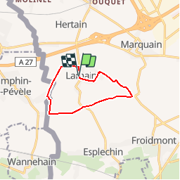
Randonnée Marche de 8,3 km à découvrir à Wallonie, Hainaut, Tournai. Cette randonnée est proposée par jacques.moulin@hotmail.com.
Description
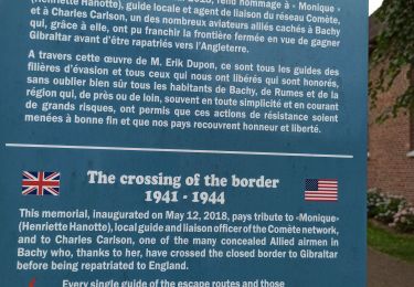
Au départ de Lamain, "ascension" vers le pilône de Froidmont, puis par une longue ligne droite, on rejoint la frontière française (La brouette). Retour vers Lamain en longeant la frontière, rue Grande Barre et rue René Lefebvre.
Localisation
Pays :
Belgique
Région :
Wallonie
Département/Province :
Hainaut
Commune :
Tournai
Localité :
Lamain
Départ:(Dec)
Départ:(UTM)
520665 ; 5605136 (31U) N.
Commentaires
Randonnées à proximité
![Randonnée V.T.T. Bachy - De Bachy à Gruson - Photo](https://media.geolcdn.com/t/375/260/ext.jpg?maxdim=2&url=https%3A%2F%2Fservices.sitytrail.com%2FGeolivesWS%2FDownloadMedia.ashx%3FTrailID%3D316832%26Media%3D15893_6.jpg)
![V.T.T. V.T.T.](https://static1.geolcdn.com/sitytour/trail-icons/202.png)
De Bachy à Gruson
V.T.T.
Moyen
(1)
Bachy,
Hauts-de-France,
Nord,
France
![](/images/other/stat-length.png)
21 km | 23 km-effort
1h 30min
![](https://static1.geolcdn.com/siteimages/upload/files/16400158638029165_repeat_loop_refresh_sync_direction_icon.png)
Oui
![Randonnée V.T.T. Gruson - De l'arbre aux Marais - Gruson - Photo](https://media.geolcdn.com/t/375/260/ext.jpg?maxdim=2&url=https%3A%2F%2Fservices.sitytrail.com%2FGeolivesWS%2FDownloadMedia.ashx%3FTrailID%3D172679%26Media%3D14061_5.jpg)
![V.T.T. V.T.T.](https://static1.geolcdn.com/sitytour/trail-icons/202.png)
De l'arbre aux Marais - Gruson
V.T.T.
Moyen
(1)
Gruson,
Hauts-de-France,
Nord,
France
![](/images/other/stat-length.png)
19,1 km | 20 km-effort
1h 30min
![](https://static1.geolcdn.com/siteimages/upload/files/16400158638029165_repeat_loop_refresh_sync_direction_icon.png)
Oui
![Randonnée Cheval Tournai - Boucle de Templeuve - Photo](https://media.geolcdn.com/t/375/260/ext.jpg?maxdim=2&url=https%3A%2F%2Fpivotmedia.tourismewallonie.be%2FANX-02-000EJK%2FANX-02-000EJK.jpg)
![Cheval Cheval](https://static1.geolcdn.com/sitytour/trail-icons/300.png)
Boucle de Templeuve
Cheval
Très facile
Tournai,
Wallonie,
Hainaut,
Belgique
![](/images/other/stat-length.png)
9,2 km | 9,8 km-effort
Inconnu
![](https://static1.geolcdn.com/siteimages/upload/files/16400158638029165_repeat_loop_refresh_sync_direction_icon.png)
Oui
![Randonnée Cheval Tournai - Boucle de Froyennes - Photo](https://media.geolcdn.com/t/375/260/ext.jpg?maxdim=2&url=https%3A%2F%2Fpivotmedia.tourismewallonie.be%2FANX-02-000EJ5%2FANX-02-000EJ5.jpg)
![Cheval Cheval](https://static1.geolcdn.com/sitytour/trail-icons/300.png)
Boucle de Froyennes
Cheval
Très facile
Tournai,
Wallonie,
Hainaut,
Belgique
![](/images/other/stat-length.png)
26 km | 28 km-effort
Inconnu
![](https://static1.geolcdn.com/siteimages/upload/files/16400158638029165_repeat_loop_refresh_sync_direction_icon.png)
Oui
![Randonnée Cheval Tournai - Boucle de Blandain - Photo](https://media.geolcdn.com/t/375/260/ext.jpg?maxdim=2&url=https%3A%2F%2Fpivotmedia.tourismewallonie.be%2FANX-02-000EJC%2FANX-02-000EJC.jpg)
![Cheval Cheval](https://static1.geolcdn.com/sitytour/trail-icons/300.png)
Boucle de Blandain
Cheval
Très facile
Tournai,
Wallonie,
Hainaut,
Belgique
![](/images/other/stat-length.png)
11,6 km | 12,4 km-effort
Inconnu
![](https://static1.geolcdn.com/siteimages/upload/files/16400158638029165_repeat_loop_refresh_sync_direction_icon.png)
Oui
![Randonnée Marche Tournai - Boucle à Orcq - Photo](https://media.geolcdn.com/t/375/260/ext.jpg?maxdim=2&url=https%3A%2F%2Fstatic1.geolcdn.com%2Fsiteimages%2Fupload%2Ffiles%2F1553511878bg_sport_marche.png)
![Marche Marche](https://static1.geolcdn.com/sitytour/trail-icons/101.png)
Boucle à Orcq
Marche
Facile
(1)
Tournai,
Wallonie,
Hainaut,
Belgique
![](/images/other/stat-length.png)
8,2 km | 9 km-effort
2h 0min
![](https://static1.geolcdn.com/siteimages/upload/files/16400158638029165_repeat_loop_refresh_sync_direction_icon.png)
Oui
![Randonnée Marche Tournai - Lamain 15 km - Photo](https://media.geolcdn.com/t/375/260/b754069d-b4d0-4eb5-b179-3f9ac814b792.jpg&format=jpg&maxdim=2)
![Marche Marche](https://static1.geolcdn.com/sitytour/trail-icons/101.png)
Lamain 15 km
Marche
Facile
Tournai,
Wallonie,
Hainaut,
Belgique
![](/images/other/stat-length.png)
15,2 km | 16,3 km-effort
4h 8min
![](https://static1.geolcdn.com/siteimages/upload/files/16400158638029165_repeat_loop_refresh_sync_direction_icon.png)
Oui
![Randonnée Marche Camphin-en-Pévèle - Camphin en Peleve 11,6 km - Photo](https://media.geolcdn.com/t/375/260/234eb050-38d1-4401-9657-0f22968d4a2b.jpg&format=jpg&maxdim=2)
![Marche Marche](https://static1.geolcdn.com/sitytour/trail-icons/101.png)
Camphin en Peleve 11,6 km
Marche
Facile
Camphin-en-Pévèle,
Hauts-de-France,
Nord,
France
![](/images/other/stat-length.png)
11,6 km | 12,3 km-effort
3h 13min
![](https://static1.geolcdn.com/siteimages/upload/files/16400158638029165_repeat_loop_refresh_sync_direction_icon.png)
Oui
![Randonnée Marche Bachy - sur les pas de Monique, version officielle - Photo](https://media.geolcdn.com/t/375/260/d1de95ec-9406-45c1-96f7-9a4adea6cbc9.jpg&format=jpg&maxdim=2)
![Marche Marche](https://static1.geolcdn.com/sitytour/trail-icons/101.png)
sur les pas de Monique, version officielle
Marche
Moyen
Bachy,
Hauts-de-France,
Nord,
France
![](/images/other/stat-length.png)
11 km | 11,8 km-effort
2h 30min
![](https://static1.geolcdn.com/siteimages/upload/files/16400158638029165_repeat_loop_refresh_sync_direction_icon.png)
Oui