![](/images/other/stat-length.png)
![Randonnée Marche Oberhaslach - 67 Boucle Schneeberg - Photo](https://media.geolcdn.com/t/1900/400/ext.pjpeg?maxdim=2&url=https%3A%2F%2Fstatic1.geolcdn.com%2Fsiteimages%2Fupload%2Ffiles%2F1553511878bg_sport_marche.png)
67 Boucle Schneeberg
LUTZMarc
Utilisateur
![Longueur](/images/other/stat-length.png)
Longueur
20 km
![Altitude max](https://static1.geolcdn.com/siteimages/upload/files/1508320355ic_sort_altitude_max_24dp.png)
Altitude max
929 m
![Dénivelé positif](https://static1.geolcdn.com/siteimages/upload/files/1508320355ic_sort_den_pos_24dp.png)
Dénivelé positif
884 m
![Km-Effort](/images/other/stat-length.png)
Km-Effort
32 km
![Altitude min](https://static1.geolcdn.com/siteimages/upload/files/1508320355ic_sort_altitude_min_24dp.png)
Altitude min
423 m
![Dénivelé négatif](https://static1.geolcdn.com/siteimages/upload/files/1508320355ic_sort_den_neg_24dp.png)
Dénivelé négatif
879 m
![Boucle](https://static1.geolcdn.com/siteimages/upload/files/16400158638029165_repeat_loop_refresh_sync_direction_icon.png)
Boucle
Oui
Date de création :
2019-11-07 08:21:59.346
Dernière modification :
2019-11-07 17:55:26.315
![Marche](https://static1.geolcdn.com/sitytour/trail-icons/101.png)
5h06
Difficulté : Moyen
![Scannez ce code QR pour ouvrir la randonnée dans l'application SityTrail](https://capi.geolives.com/qq0zvz2zws4bq2lad0pu/sitytour/trails/2259517/qr.png?size=200)
Application GPS de randonnée GRATUITE
À propos
Randonnée Marche de 20 km à découvrir à Grand Est, Bas-Rhin, Oberhaslach. Cette randonnée est proposée par LUTZMarc.
Description
La rando est principalement sur des sentier en forêt. Très agréable aà marcher. Ça monte bien par moment. Possibilité de manger à l'auberge du château à Wangenbourg km 12.
Localisation
Pays :
France
Région :
Grand Est
Département/Province :
Bas-Rhin
Commune :
Oberhaslach
Localité :
Unknown
Départ:(Dec)
Départ:(UTM)
373846 ; 5382873 (32U) N.
Commentaires
Randonnées à proximité
![Randonnée Randonnée équestre Oberhaslach - Neufeld Boucle Elmersforst - Photo](https://media.geolcdn.com/t/375/260/ext.jpg?maxdim=2&url=https%3A%2F%2Fstatic1.geolcdn.com%2Fsiteimages%2Fupload%2Ffiles%2F1524743154cheval.jpg)
![Randonnée équestre Randonnée équestre](https://static1.geolcdn.com/sitytour/trail-icons/301.png)
Neufeld Boucle Elmersforst
Randonnée équestre
Difficile
(1)
Oberhaslach,
Grand Est,
Bas-Rhin,
France
![](/images/other/stat-length.png)
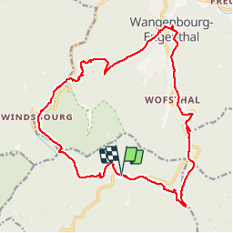
31 km | 42 km-effort
5h 9min
![](https://static1.geolcdn.com/siteimages/upload/files/16400158638029165_repeat_loop_refresh_sync_direction_icon.png)
Oui
![Randonnée Marche Lutzelhouse - 2013-05-10 Marche Rocher de Mutzig par Nideck - Photo](https://media.geolcdn.com/t/375/260/ext.jpg?maxdim=2&url=https%3A%2F%2Fstatic1.geolcdn.com%2Fsiteimages%2Fupload%2Ffiles%2F1553511878bg_sport_marche.png)
![Marche Marche](https://static1.geolcdn.com/sitytour/trail-icons/101.png)
2013-05-10 Marche Rocher de Mutzig par Nideck
Marche
Moyen
(1)
Lutzelhouse,
Grand Est,
Bas-Rhin,
France
![](/images/other/stat-length.png)
14,9 km | 24 km-effort
4h 10min
![](https://static1.geolcdn.com/siteimages/upload/files/16400158638029165_repeat_loop_refresh_sync_direction_icon.png)
Oui
![Randonnée V.T.T. Oberhaslach - Rando des Feuilles Mortes - Photo](https://media.geolcdn.com/t/375/260/ext.jpg?maxdim=2&url=https%3A%2F%2Fservices.sitytrail.com%2FGeolivesWS%2FDownloadMedia.ashx%3FTrailID%3D101060%26Media%3D551_1.jpg)
![V.T.T. V.T.T.](https://static1.geolcdn.com/sitytour/trail-icons/202.png)
Rando des Feuilles Mortes
V.T.T.
Moyen
(2)
Oberhaslach,
Grand Est,
Bas-Rhin,
France
![](/images/other/stat-length.png)
29 km | 41 km-effort
2h 0min
![](https://static1.geolcdn.com/siteimages/upload/files/16400158638029165_repeat_loop_refresh_sync_direction_icon.png)
Oui
![Randonnée Randonnée équestre Niederhaslach - Toutes fugues - Photo](https://media.geolcdn.com/t/375/260/ext.jpg?maxdim=2&url=https%3A%2F%2Fstatic1.geolcdn.com%2Fsiteimages%2Fupload%2Ffiles%2F1524743154cheval.jpg)
![Randonnée équestre Randonnée équestre](https://static1.geolcdn.com/sitytour/trail-icons/301.png)
Toutes fugues
Randonnée équestre
Facile
(1)
Niederhaslach,
Grand Est,
Bas-Rhin,
France
![](/images/other/stat-length.png)
29 km | 39 km-effort
Inconnu
![](https://static1.geolcdn.com/siteimages/upload/files/16400158638029165_repeat_loop_refresh_sync_direction_icon.png)
Oui
![Randonnée Randonnée équestre Still - 2022-07-10 Picnic CVA Umwurf depuis Oberhaslach - Photo](https://media.geolcdn.com/t/375/260/345719c4-c8c7-4272-8b46-e89c45a30cba.jpg&format=jpg&maxdim=2)
![Randonnée équestre Randonnée équestre](https://static1.geolcdn.com/sitytour/trail-icons/301.png)
2022-07-10 Picnic CVA Umwurf depuis Oberhaslach
Randonnée équestre
Difficile
Still,
Grand Est,
Bas-Rhin,
France
![](/images/other/stat-length.png)
28 km | 40 km-effort
5h 53min
![](https://static1.geolcdn.com/siteimages/upload/files/16400158638029165_repeat_loop_refresh_sync_direction_icon.png)
Oui
![Randonnée Marche Dabo - 2020-06-01 Marche Hengst - Photo](https://media.geolcdn.com/t/375/260/188abe8d-f41e-44e5-a426-fbd2513d6d58.jpg&format=jpg&maxdim=2)
![Marche Marche](https://static1.geolcdn.com/sitytour/trail-icons/101.png)
2020-06-01 Marche Hengst
Marche
Très facile
Dabo,
Grand Est,
Moselle,
France
![](/images/other/stat-length.png)
13,8 km | 18,7 km-effort
4h 18min
![](https://static1.geolcdn.com/siteimages/upload/files/16400158638029165_repeat_loop_refresh_sync_direction_icon.png)
Oui
![Randonnée Marche Wangenbourg-Engenthal - 2019-11-16 Marche Wangenbourg Castelberg - Photo](https://media.geolcdn.com/t/375/260/5fe565fb-6e88-4bed-a889-a75a33bb061a.jpg&format=jpg&maxdim=2)
![Marche Marche](https://static1.geolcdn.com/sitytour/trail-icons/101.png)
2019-11-16 Marche Wangenbourg Castelberg
Marche
Très facile
Wangenbourg-Engenthal,
Grand Est,
Bas-Rhin,
France
![](/images/other/stat-length.png)
19,8 km | 31 km-effort
4h 51min
![](https://static1.geolcdn.com/siteimages/upload/files/16400158638029165_repeat_loop_refresh_sync_direction_icon.png)
Oui
![Randonnée Marche Wangenbourg-Engenthal - 2017-02-24 Marche Schneeberg - Photo](https://media.geolcdn.com/t/375/260/ext.jpg?maxdim=2&url=https%3A%2F%2Fstatic1.geolcdn.com%2Fsiteimages%2Fupload%2Ffiles%2F1553511878bg_sport_marche.png)
![Marche Marche](https://static1.geolcdn.com/sitytour/trail-icons/101.png)
2017-02-24 Marche Schneeberg
Marche
Très facile
(1)
Wangenbourg-Engenthal,
Grand Est,
Bas-Rhin,
France
![](/images/other/stat-length.png)
12,8 km | 19,9 km-effort
Inconnu
![](https://static1.geolcdn.com/siteimages/upload/files/16400158638029165_repeat_loop_refresh_sync_direction_icon.png)
Oui
![Randonnée Marche Oberhaslach - roche pfaffenlapp. oberhaslach - Photo](https://media.geolcdn.com/t/375/260/0d04f4b1-4b41-46da-b2c9-b0e99bb514b5.jpg&format=jpg&maxdim=2)
![Marche Marche](https://static1.geolcdn.com/sitytour/trail-icons/101.png)
roche pfaffenlapp. oberhaslach
Marche
Moyen
Oberhaslach,
Grand Est,
Bas-Rhin,
France
![](/images/other/stat-length.png)
10,4 km | 17,3 km-effort
5h 5min
![](https://static1.geolcdn.com/siteimages/upload/files/16400158638029165_repeat_loop_refresh_sync_direction_icon.png)
Oui