![](/images/other/stat-length.png)
![Randonnée A pied Bessans - le Clot de Bessans - Photo](https://media.geolcdn.com/t/1900/400/ext.pjpeg?maxdim=2&url=https%3A%2F%2Fstatic1.geolcdn.com%2Fsiteimages%2Fupload%2Ffiles%2F1545311037marcheuse_200dpi.jpg)
le Clot de Bessans
ROBERTcgJ
Utilisateur
![Longueur](/images/other/stat-length.png)
Longueur
4,2 km
![Altitude max](https://static1.geolcdn.com/siteimages/upload/files/1508320355ic_sort_altitude_max_24dp.png)
Altitude max
2072 m
![Dénivelé positif](https://static1.geolcdn.com/siteimages/upload/files/1508320355ic_sort_den_pos_24dp.png)
Dénivelé positif
360 m
![Km-Effort](/images/other/stat-length.png)
Km-Effort
9 km
![Altitude min](https://static1.geolcdn.com/siteimages/upload/files/1508320355ic_sort_altitude_min_24dp.png)
Altitude min
1699 m
![Dénivelé négatif](https://static1.geolcdn.com/siteimages/upload/files/1508320355ic_sort_den_neg_24dp.png)
Dénivelé négatif
361 m
![Boucle](https://static1.geolcdn.com/siteimages/upload/files/16400158638029165_repeat_loop_refresh_sync_direction_icon.png)
Boucle
Non
Date de création :
2019-11-02 18:34:25.736
Dernière modification :
2019-11-02 18:51:25.221
![A pied](https://static1.geolcdn.com/sitytour/trail-icons/100.png)
--
Difficulté : Facile
![Scannez ce code QR pour ouvrir la randonnée dans l'application SityTrail](https://capi.geolives.com/qq0zvz2zws4bq2lad0pu/sitytour/trails/2256166/qr.png?size=200)
Application GPS de randonnée GRATUITE
À propos
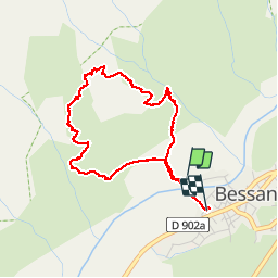
Randonnée A pied de 4,2 km à découvrir à Auvergne-Rhône-Alpes, Savoie, Bessans. Cette randonnée est proposée par ROBERTcgJ.
Description
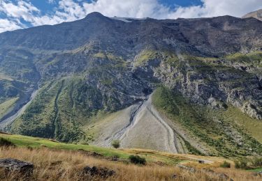
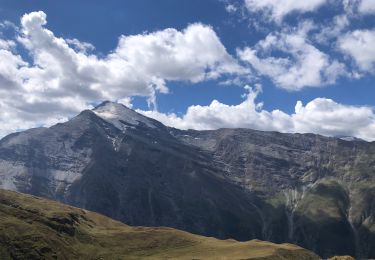
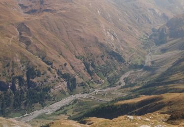
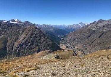
boucle permettant de dominer le village de Bessans et son site unique dans les Alpes.
Attention, descente raide sur un sentier mal tracé au départ (viser la plantation de mélèzes à mi-pente).
Localisation
Pays :
France
Région :
Auvergne-Rhône-Alpes
Département/Province :
Savoie
Commune :
Bessans
Localité :
Unknown
Départ:(Dec)
Départ:(UTM)
342387 ; 5020596 (32T) N.
Commentaires
Randonnées à proximité
![Randonnée Marche Bessans - refuge d'Averole - Photo](https://media.geolcdn.com/t/375/260/ext.jpg?maxdim=2&url=https%3A%2F%2Fservices.sitytrail.com%2FGeolivesWS%2FDownloadMedia.ashx%3FTrailID%3D617286%26Media%3Dfix__20160819132126.jpg)
![Marche Marche](https://static1.geolcdn.com/sitytour/trail-icons/101.png)
refuge d'Averole
Marche
Facile
Bessans,
Auvergne-Rhône-Alpes,
Savoie,
France
![](/images/other/stat-length.png)
11,1 km | 16,7 km-effort
4h 37min
![](https://static1.geolcdn.com/siteimages/upload/files/16400158638029165_repeat_loop_refresh_sync_direction_icon.png)
Oui
![Randonnée Marche Bessans - La Mottuaz et la Buffaz depuis Vincendières - Photo](https://media.geolcdn.com/t/375/260/ext.jpg?maxdim=2&url=https%3A%2F%2Fmedia.geolcdn.com%2Ff%2F20fcd3bf-bd73-46aa-8e80-be17fc92c70e.jpg)
![Marche Marche](https://static1.geolcdn.com/sitytour/trail-icons/101.png)
La Mottuaz et la Buffaz depuis Vincendières
Marche
Difficile
Bessans,
Auvergne-Rhône-Alpes,
Savoie,
France
![](/images/other/stat-length.png)
11,3 km | 21 km-effort
5h 48min
![](https://static1.geolcdn.com/siteimages/upload/files/16400158638029165_repeat_loop_refresh_sync_direction_icon.png)
Oui
![Randonnée Marche Bessans - Glacier du grand fond à Bessans - Photo](https://media.geolcdn.com/t/375/260/ext.jpg?maxdim=2&url=https%3A%2F%2Fmedia.geolcdn.com%2Ff%2F61f5a8e8-d661-4c78-8114-74bcc9d0d732.jpg)
![Marche Marche](https://static1.geolcdn.com/sitytour/trail-icons/101.png)
Glacier du grand fond à Bessans
Marche
Difficile
Bessans,
Auvergne-Rhône-Alpes,
Savoie,
France
![](/images/other/stat-length.png)
15,8 km | 34 km-effort
8h 22min
![](https://static1.geolcdn.com/siteimages/upload/files/16400158638029165_repeat_loop_refresh_sync_direction_icon.png)
Non
![Randonnée Ski de randonnée Bessans - Ouille Allegra - Photo](https://media.geolcdn.com/t/375/260/ext.jpg?maxdim=2&url=https%3A%2F%2Fmedia.geolcdn.com%2Ff%2F9b5085c5-d222-4758-bb24-52aa6805627c.jpg)
![Ski de randonnée Ski de randonnée](https://static1.geolcdn.com/sitytour/trail-icons/503.png)
Ouille Allegra
Ski de randonnée
Moyen
Bessans,
Auvergne-Rhône-Alpes,
Savoie,
France
![](/images/other/stat-length.png)
15,6 km | 34 km-effort
4h 43min
![](https://static1.geolcdn.com/siteimages/upload/files/16400158638029165_repeat_loop_refresh_sync_direction_icon.png)
Oui
![Randonnée Marche Bessans - la chapelle de tierce - Photo](https://media.geolcdn.com/t/375/260/ext.jpg?maxdim=2&url=https%3A%2F%2Fmedia.geolcdn.com%2Ff%2F198d2c98-080a-46a4-bb50-3b24f6158577.jpg)
![Marche Marche](https://static1.geolcdn.com/sitytour/trail-icons/101.png)
la chapelle de tierce
Marche
Difficile
Bessans,
Auvergne-Rhône-Alpes,
Savoie,
France
![](/images/other/stat-length.png)
14,5 km | 32 km-effort
6h 19min
![](https://static1.geolcdn.com/siteimages/upload/files/16400158638029165_repeat_loop_refresh_sync_direction_icon.png)
Oui
![Randonnée Marche Bessans - Parking à côté de Vincendières - Ouille d'Allegra BESSAN - Photo](https://media.geolcdn.com/t/375/260/ext.jpg?maxdim=2&url=https%3A%2F%2Fmedia.geolcdn.com%2Ff%2Feca17c70-22c9-4bd4-954d-dbe983db8fc1.jpg)
![Marche Marche](https://static1.geolcdn.com/sitytour/trail-icons/101.png)
Parking à côté de Vincendières - Ouille d'Allegra BESSAN
Marche
Difficile
Bessans,
Auvergne-Rhône-Alpes,
Savoie,
France
![](/images/other/stat-length.png)
12,6 km | 30 km-effort
7h 20min
![](https://static1.geolcdn.com/siteimages/upload/files/16400158638029165_repeat_loop_refresh_sync_direction_icon.png)
Oui
![Randonnée Marche Bessans - chapelle de tierce - Photo](https://media.geolcdn.com/t/375/260/ext.jpg?maxdim=2&url=https%3A%2F%2Fmedia.geolcdn.com%2Ff%2Fa7930c12-dd5d-4c05-b286-cc502cf51c39.jpg)
![Marche Marche](https://static1.geolcdn.com/sitytour/trail-icons/101.png)
chapelle de tierce
Marche
Difficile
Bessans,
Auvergne-Rhône-Alpes,
Savoie,
France
![](/images/other/stat-length.png)
13,8 km | 31 km-effort
5h 30min
![](https://static1.geolcdn.com/siteimages/upload/files/16400158638029165_repeat_loop_refresh_sync_direction_icon.png)
Oui
![Randonnée A pied Bessans - Circuit du Gypaète - Photo](https://media.geolcdn.com/t/375/260/ext.jpg?maxdim=2&url=https%3A%2F%2Fmedia.geolcdn.com%2Ff%2F35516eac-6b39-431a-84d8-a68319860bc8.jpg)
![A pied A pied](https://static1.geolcdn.com/sitytour/trail-icons/100.png)
Circuit du Gypaète
A pied
Moyen
Bessans,
Auvergne-Rhône-Alpes,
Savoie,
France
![](/images/other/stat-length.png)
8,3 km | 10,5 km-effort
Inconnu
![](https://static1.geolcdn.com/siteimages/upload/files/16400158638029165_repeat_loop_refresh_sync_direction_icon.png)
Oui
![Randonnée Marche Bessans - refuge de l'avérole - Photo](https://media.geolcdn.com/t/375/260/ext.jpg?maxdim=2&url=https%3A%2F%2Fmedia.geolcdn.com%2Ff%2Fc1e02381-b2c0-4f29-93e3-908061cf8835.jpg)
![Marche Marche](https://static1.geolcdn.com/sitytour/trail-icons/101.png)
refuge de l'avérole
Marche
Très facile
Bessans,
Auvergne-Rhône-Alpes,
Savoie,
France
![](/images/other/stat-length.png)
11,1 km | 16,5 km-effort
4h 27min
![](https://static1.geolcdn.com/siteimages/upload/files/16400158638029165_repeat_loop_refresh_sync_direction_icon.png)
Oui