![](/images/other/stat-length.png)
![Randonnée Marche Val-de-Charmey - - Photo](https://media.geolcdn.com/t/1900/400/ext.pjpeg?maxdim=2&url=https%3A%2F%2Fstatic1.geolcdn.com%2Fsiteimages%2Fupload%2Ffiles%2F1553511878bg_sport_marche.png)
labrune
Utilisateur
![Longueur](/images/other/stat-length.png)
Longueur
11,4 km
![Altitude max](https://static1.geolcdn.com/siteimages/upload/files/1508320355ic_sort_altitude_max_24dp.png)
Altitude max
1619 m
![Dénivelé positif](https://static1.geolcdn.com/siteimages/upload/files/1508320355ic_sort_den_pos_24dp.png)
Dénivelé positif
519 m
![Km-Effort](/images/other/stat-length.png)
Km-Effort
18,3 km
![Altitude min](https://static1.geolcdn.com/siteimages/upload/files/1508320355ic_sort_altitude_min_24dp.png)
Altitude min
1358 m
![Dénivelé négatif](https://static1.geolcdn.com/siteimages/upload/files/1508320355ic_sort_den_neg_24dp.png)
Dénivelé négatif
521 m
![Boucle](https://static1.geolcdn.com/siteimages/upload/files/16400158638029165_repeat_loop_refresh_sync_direction_icon.png)
Boucle
Oui
Date de création :
2014-12-11 00:00:00.0
Dernière modification :
2014-12-11 00:00:00.0
![Marche](https://static1.geolcdn.com/sitytour/trail-icons/101.png)
--
Difficulté : Inconnu
![Scannez ce code QR pour ouvrir la randonnée dans l'application SityTrail](https://capi.geolives.com/qq0zvz2zws4bq2lad0pu/sitytour/trails/22539/qr.png?size=200)
Application GPS de randonnée GRATUITE
À propos
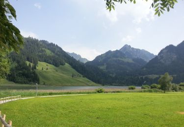
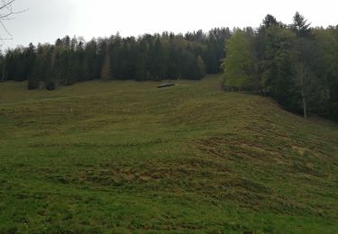
Randonnée Marche de 11,4 km à découvrir à Fribourg, District de la Gruyère, Val-de-Charmey. Cette randonnée est proposée par labrune.
Description
2.30 h. = marche réelle (GPS)
Départ Auta-Chia - La Patta - 1487 - Fuchses Schwyberg - Hapferen Schwyberg - Philiponerwald - 1487 - 1532 - La Chevrille - Auta-Chia
Localisation
Pays :
Suisse
Région :
Fribourg
Département/Province :
District de la Gruyère
Commune :
Val-de-Charmey
Localité :
Cerniat (FR)
Départ:(Dec)
Départ:(UTM)
364390 ; 5169716 (32T) N.
Commentaires
Randonnées à proximité
![Randonnée A pied Planfayon - Schwarzsee Bad Seeweid - fixme - Photo](https://media.geolcdn.com/t/375/260/662ba53b-2cbe-4817-abf8-d27fdcd1220d.jpeg&format=jpg&maxdim=2)
![A pied A pied](https://static1.geolcdn.com/sitytour/trail-icons/100.png)
Schwarzsee Bad Seeweid - fixme
A pied
Facile
Planfayon,
Fribourg,
District de la Singine,
Suisse
![](/images/other/stat-length.png)
4,2 km | 9,8 km-effort
2h 13min
![](https://static1.geolcdn.com/siteimages/upload/files/16400158638029165_repeat_loop_refresh_sync_direction_icon.png)
Non
![Randonnée A pied Planfayon - Schwarzsee Bad Seeweid - Patraflon - Photo](https://media.geolcdn.com/t/375/260/662ba53b-2cbe-4817-abf8-d27fdcd1220d.jpeg&format=jpg&maxdim=2)
![A pied A pied](https://static1.geolcdn.com/sitytour/trail-icons/100.png)
Schwarzsee Bad Seeweid - Patraflon
A pied
Facile
Planfayon,
Fribourg,
District de la Singine,
Suisse
![](/images/other/stat-length.png)
4,5 km | 12,4 km-effort
2h 49min
![](https://static1.geolcdn.com/siteimages/upload/files/16400158638029165_repeat_loop_refresh_sync_direction_icon.png)
Non
![Randonnée A pied Planfayon - Schwarzsee Bad Seeweid - Unteri (Steinig) Rippa - Photo](https://media.geolcdn.com/t/375/260/662ba53b-2cbe-4817-abf8-d27fdcd1220d.jpeg&format=jpg&maxdim=2)
![A pied A pied](https://static1.geolcdn.com/sitytour/trail-icons/100.png)
Schwarzsee Bad Seeweid - Unteri (Steinig) Rippa
A pied
Facile
Planfayon,
Fribourg,
District de la Singine,
Suisse
![](/images/other/stat-length.png)
4,9 km | 10,2 km-effort
2h 18min
![](https://static1.geolcdn.com/siteimages/upload/files/16400158638029165_repeat_loop_refresh_sync_direction_icon.png)
Non
![Randonnée A pied Planfayon - Schwarzsee Bad Seeweid - fixme - Photo](https://media.geolcdn.com/t/375/260/662ba53b-2cbe-4817-abf8-d27fdcd1220d.jpeg&format=jpg&maxdim=2)
![A pied A pied](https://static1.geolcdn.com/sitytour/trail-icons/100.png)
Schwarzsee Bad Seeweid - fixme
A pied
Facile
Planfayon,
Fribourg,
District de la Singine,
Suisse
![](/images/other/stat-length.png)
3,6 km | 8,4 km-effort
1h 54min
![](https://static1.geolcdn.com/siteimages/upload/files/16400158638029165_repeat_loop_refresh_sync_direction_icon.png)
Non
![Randonnée A pied Plasselb - Falli-Hölli - Fuchses Schwyberg - Photo](https://media.geolcdn.com/t/375/260/7b4941d9-b2aa-46a1-80d5-a4cfad4669e9.jpeg&format=jpg&maxdim=2)
![A pied A pied](https://static1.geolcdn.com/sitytour/trail-icons/100.png)
Falli-Hölli - Fuchses Schwyberg
A pied
Facile
Plasselb,
Fribourg,
District de la Singine,
Suisse
![](/images/other/stat-length.png)
6,8 km | 11,9 km-effort
2h 41min
![](https://static1.geolcdn.com/siteimages/upload/files/16400158638029165_repeat_loop_refresh_sync_direction_icon.png)
Non
![Randonnée Marche nordique Val-de-Charmey - Treek charmey au lac noir. - Photo](https://media.geolcdn.com/t/375/260/c3daf44f-29a6-4be1-822b-7f9c2cadf768.jpg&format=jpg&maxdim=2)
![Marche nordique Marche nordique](https://static1.geolcdn.com/sitytour/trail-icons/102.png)
Treek charmey au lac noir.
Marche nordique
Facile
Val-de-Charmey,
Fribourg,
District de la Gruyère,
Suisse
![](/images/other/stat-length.png)
21 km | 33 km-effort
5h 4min
![](https://static1.geolcdn.com/siteimages/upload/files/16400158638029165_repeat_loop_refresh_sync_direction_icon.png)
Oui
![Randonnée A pied Plasselb - fixme - fixme - Photo](https://media.geolcdn.com/t/375/260/ext.jpg?maxdim=2&url=https%3A%2F%2Fstatic1.geolcdn.com%2Fsiteimages%2Fupload%2Ffiles%2F1545311037marcheuse_200dpi.jpg)
![A pied A pied](https://static1.geolcdn.com/sitytour/trail-icons/100.png)
fixme - fixme
A pied
Facile
Plasselb,
Fribourg,
District de la Singine,
Suisse
![](/images/other/stat-length.png)
3,7 km | 8,7 km-effort
1h 58min
![](https://static1.geolcdn.com/siteimages/upload/files/16400158638029165_repeat_loop_refresh_sync_direction_icon.png)
Non
![Randonnée A pied Plasselb - Hapferen Schwyberg - Falli-Hölli - Photo](https://media.geolcdn.com/t/375/260/ext.jpg?maxdim=2&url=https%3A%2F%2Fstatic1.geolcdn.com%2Fsiteimages%2Fupload%2Ffiles%2F1545311037marcheuse_200dpi.jpg)
![A pied A pied](https://static1.geolcdn.com/sitytour/trail-icons/100.png)
Hapferen Schwyberg - Falli-Hölli
A pied
Facile
Plasselb,
Fribourg,
District de la Singine,
Suisse
![](/images/other/stat-length.png)
5,5 km | 7,2 km-effort
1h 38min
![](https://static1.geolcdn.com/siteimages/upload/files/16400158638029165_repeat_loop_refresh_sync_direction_icon.png)
Non
![Randonnée Marche Planfayon - hike04 - Photo](https://media.geolcdn.com/t/375/260/ext.jpg?maxdim=2&url=https%3A%2F%2Fstatic1.geolcdn.com%2Fsiteimages%2Fupload%2Ffiles%2F1553511878bg_sport_marche.png)
![Marche Marche](https://static1.geolcdn.com/sitytour/trail-icons/101.png)
hike04
Marche
Très facile
Planfayon,
Fribourg,
District de la Singine,
Suisse
![](/images/other/stat-length.png)
16,1 km | 24 km-effort
Inconnu
![](https://static1.geolcdn.com/siteimages/upload/files/16400158638029165_repeat_loop_refresh_sync_direction_icon.png)
Non