![](/images/other/stat-length.png)
![Randonnée Marche Métabief - Metabief//Le Pont - Photo](https://media.geolcdn.com/t/1900/400/ext.pjpeg?maxdim=2&url=https%3A%2F%2Fstatic1.geolcdn.com%2Fsiteimages%2Fupload%2Ffiles%2F1553511878bg_sport_marche.png)
Metabief//Le Pont
BM25
Utilisateur
![Longueur](/images/other/stat-length.png)
Longueur
19,9 km
![Altitude max](https://static1.geolcdn.com/siteimages/upload/files/1508320355ic_sort_altitude_max_24dp.png)
Altitude max
1470 m
![Dénivelé positif](https://static1.geolcdn.com/siteimages/upload/files/1508320355ic_sort_den_pos_24dp.png)
Dénivelé positif
1143 m
![Km-Effort](/images/other/stat-length.png)
Km-Effort
35 km
![Altitude min](https://static1.geolcdn.com/siteimages/upload/files/1508320355ic_sort_altitude_min_24dp.png)
Altitude min
930 m
![Dénivelé négatif](https://static1.geolcdn.com/siteimages/upload/files/1508320355ic_sort_den_neg_24dp.png)
Dénivelé négatif
1147 m
![Boucle](https://static1.geolcdn.com/siteimages/upload/files/16400158638029165_repeat_loop_refresh_sync_direction_icon.png)
Boucle
Non
Date de création :
2019-10-30 08:12:38.032
Dernière modification :
2019-10-30 14:07:48.993
![Marche](https://static1.geolcdn.com/sitytour/trail-icons/101.png)
5h54
Difficulté : Très facile
![Scannez ce code QR pour ouvrir la randonnée dans l'application SityTrail](https://capi.geolives.com/qq0zvz2zws4bq2lad0pu/sitytour/trails/2253779/qr.png?size=200)
Application GPS de randonnée GRATUITE
À propos
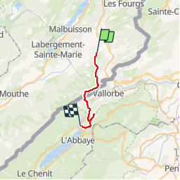
Randonnée Marche de 19,9 km à découvrir à Bourgogne-Franche-Comté, Doubs, Métabief. Cette randonnée est proposée par BM25.
Description
depuis station Metabief montée au sommet puis les cretes jusqu'à la petite échelle, descente vers Juraparc ,montée à la dent de Vaulion puis descente au Pont
Localisation
Pays :
France
Région :
Bourgogne-Franche-Comté
Département/Province :
Doubs
Commune :
Métabief
Localité :
Unknown
Départ:(Dec)
Départ:(UTM)
298216 ; 5182759 (32T) N.
Commentaires
Randonnées à proximité
![Randonnée A pied Ballaigues - Ballaigues-Vallorbe - Photo](https://media.geolcdn.com/t/375/260/ext.jpg?maxdim=2&url=https%3A%2F%2Fmedia.geolcdn.com%2Ff%2F94e39ae2-cd96-4289-ab6b-b58b7f70c35d.jpeg)
![A pied A pied](https://static1.geolcdn.com/sitytour/trail-icons/100.png)
Ballaigues-Vallorbe
A pied
Facile
Ballaigues,
Vaud,
District du Jura-Nord vaudois,
Suisse
![](/images/other/stat-length.png)
5,1 km | 6,3 km-effort
1h 25min
![](https://static1.geolcdn.com/siteimages/upload/files/16400158638029165_repeat_loop_refresh_sync_direction_icon.png)
Non
![Randonnée Marche Métabief - GTJ Metabief - Pontarlier - Photo](https://media.geolcdn.com/t/375/260/ext.jpg?maxdim=2&url=https%3A%2F%2Fstatic1.geolcdn.com%2Fsiteimages%2Fupload%2Ffiles%2F1553511878bg_sport_marche.png)
![Marche Marche](https://static1.geolcdn.com/sitytour/trail-icons/101.png)
GTJ Metabief - Pontarlier
Marche
Moyen
(1)
Métabief,
Bourgogne-Franche-Comté,
Doubs,
France
![](/images/other/stat-length.png)
25 km | 35 km-effort
7h 17min
![](https://static1.geolcdn.com/siteimages/upload/files/16400158638029165_repeat_loop_refresh_sync_direction_icon.png)
Non
![Randonnée Marche Saint-Antoine - Boucle du fort St Antoine - Photo](https://media.geolcdn.com/t/375/260/ext.jpg?maxdim=2&url=https%3A%2F%2Fmedia.geolcdn.com%2Ff%2F39387965-6cd2-4b9c-a9a7-b089cab08bc2.jpg)
![Marche Marche](https://static1.geolcdn.com/sitytour/trail-icons/101.png)
Boucle du fort St Antoine
Marche
Moyen
Saint-Antoine,
Bourgogne-Franche-Comté,
Doubs,
France
![](/images/other/stat-length.png)
4,8 km | 6,2 km-effort
1h 25min
![](https://static1.geolcdn.com/siteimages/upload/files/16400158638029165_repeat_loop_refresh_sync_direction_icon.png)
Oui
![Randonnée Marche Rochejean - Mont d'or - Photo](https://media.geolcdn.com/t/375/260/ext.jpg?maxdim=2&url=https%3A%2F%2Fmedia.geolcdn.com%2Ff%2F22137291-8125-4d4b-9cc5-d81179db76e3.jpg)
![Marche Marche](https://static1.geolcdn.com/sitytour/trail-icons/101.png)
Mont d'or
Marche
Facile
Rochejean,
Bourgogne-Franche-Comté,
Doubs,
France
![](/images/other/stat-length.png)
11,9 km | 17,5 km-effort
4h 53min
![](https://static1.geolcdn.com/siteimages/upload/files/16400158638029165_repeat_loop_refresh_sync_direction_icon.png)
Oui
![Randonnée A pied Malbuisson - Sentier du Tour du Lac - Photo](https://media.geolcdn.com/t/375/260/ext.jpg?maxdim=2&url=https%3A%2F%2Fmedia.geolcdn.com%2Ff%2Fec9f6be9-4d56-4db2-b65f-5890444a2963.jpeg)
![A pied A pied](https://static1.geolcdn.com/sitytour/trail-icons/100.png)
Sentier du Tour du Lac
A pied
Facile
Malbuisson,
Bourgogne-Franche-Comté,
Doubs,
France
![](/images/other/stat-length.png)
16 km | 19,9 km-effort
4h 30min
![](https://static1.geolcdn.com/siteimages/upload/files/16400158638029165_repeat_loop_refresh_sync_direction_icon.png)
Non
![Randonnée Raquettes à neige Métabief - Les hauteurs de Metabief - Photo](https://media.geolcdn.com/t/375/260/ext.jpg?maxdim=2&url=https%3A%2F%2Fmedia.geolcdn.com%2Ff%2F33f04111-8af2-4c09-927f-ba23e9559149.jpg)
![Raquettes à neige Raquettes à neige](https://static1.geolcdn.com/sitytour/trail-icons/504.png)
Les hauteurs de Metabief
Raquettes à neige
Moyen
Métabief,
Bourgogne-Franche-Comté,
Doubs,
France
![](/images/other/stat-length.png)
15,5 km | 23 km-effort
3h 51min
![](https://static1.geolcdn.com/siteimages/upload/files/16400158638029165_repeat_loop_refresh_sync_direction_icon.png)
Oui
![Randonnée Marche nordique Malbuisson - Fort St Antoine - Photo](https://media.geolcdn.com/t/375/260/ext.jpg?maxdim=2&url=https%3A%2F%2Fmedia.geolcdn.com%2Ff%2Ffe4e7a22-394a-4da9-be49-1254fdb85bde.jpg)
![Marche nordique Marche nordique](https://static1.geolcdn.com/sitytour/trail-icons/102.png)
Fort St Antoine
Marche nordique
Facile
Malbuisson,
Bourgogne-Franche-Comté,
Doubs,
France
![](/images/other/stat-length.png)
5,8 km | 7,3 km-effort
2h 21min
![](https://static1.geolcdn.com/siteimages/upload/files/16400158638029165_repeat_loop_refresh_sync_direction_icon.png)
Oui
![Randonnée Ski de fond Les Hôpitaux-Vieux - Les Essarts - Photo](https://media.geolcdn.com/t/375/260/ext.jpg?maxdim=2&url=https%3A%2F%2Fmedia.geolcdn.com%2Ff%2F133bf42f-84e7-4637-b480-7581e8a779ca.jpg)
![Ski de fond Ski de fond](https://static1.geolcdn.com/sitytour/trail-icons/502.png)
Les Essarts
Ski de fond
Facile
Les Hôpitaux-Vieux,
Bourgogne-Franche-Comté,
Doubs,
France
![](/images/other/stat-length.png)
6,5 km | 8,1 km-effort
2h 3min
![](https://static1.geolcdn.com/siteimages/upload/files/16400158638029165_repeat_loop_refresh_sync_direction_icon.png)
Oui
![Randonnée Marche Jougne - La Jougnena - Photo](https://media.geolcdn.com/t/375/260/ext.jpg?maxdim=2&url=https%3A%2F%2Fstatic1.geolcdn.com%2Fsiteimages%2Fupload%2Ffiles%2F1553511878bg_sport_marche.png)
![Marche Marche](https://static1.geolcdn.com/sitytour/trail-icons/101.png)
La Jougnena
Marche
Très difficile
(1)
Jougne,
Bourgogne-Franche-Comté,
Doubs,
France
![](/images/other/stat-length.png)
17,7 km | 24 km-effort
5h 32min
![](https://static1.geolcdn.com/siteimages/upload/files/16400158638029165_repeat_loop_refresh_sync_direction_icon.png)
Oui