![](/images/other/stat-length.png)
![Randonnée Marche Redortiers - E_REDORTIERS 04150 Terres du Roux - Photo](https://media.geolcdn.com/t/1900/400/ext.pjpeg?maxdim=2&url=https%3A%2F%2Fstatic1.geolcdn.com%2Fsiteimages%2Fupload%2Ffiles%2F1553511878bg_sport_marche.png)
E_REDORTIERS 04150 Terres du Roux
ANDREJAC
Utilisateur
![Longueur](/images/other/stat-length.png)
Longueur
5,5 km
![Altitude max](https://static1.geolcdn.com/siteimages/upload/files/1508320355ic_sort_altitude_max_24dp.png)
Altitude max
1327 m
![Dénivelé positif](https://static1.geolcdn.com/siteimages/upload/files/1508320355ic_sort_den_pos_24dp.png)
Dénivelé positif
150 m
![Km-Effort](/images/other/stat-length.png)
Km-Effort
7,5 km
![Altitude min](https://static1.geolcdn.com/siteimages/upload/files/1508320355ic_sort_altitude_min_24dp.png)
Altitude min
1206 m
![Dénivelé négatif](https://static1.geolcdn.com/siteimages/upload/files/1508320355ic_sort_den_neg_24dp.png)
Dénivelé négatif
151 m
![Boucle](https://static1.geolcdn.com/siteimages/upload/files/16400158638029165_repeat_loop_refresh_sync_direction_icon.png)
Boucle
Oui
Date de création :
2014-12-10 00:00:00.0
Dernière modification :
2014-12-10 00:00:00.0
![Marche](https://static1.geolcdn.com/sitytour/trail-icons/101.png)
2h00
Difficulté : Facile
![Scannez ce code QR pour ouvrir la randonnée dans l'application SityTrail](https://capi.geolives.com/qq0zvz2zws4bq2lad0pu/sitytour/trails/223956/qr.png?size=200)
Application GPS de randonnée GRATUITE
À propos
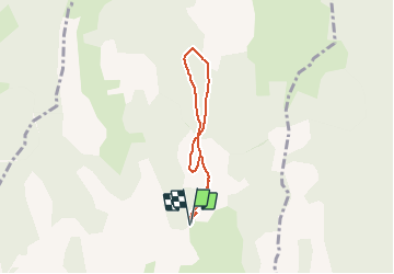
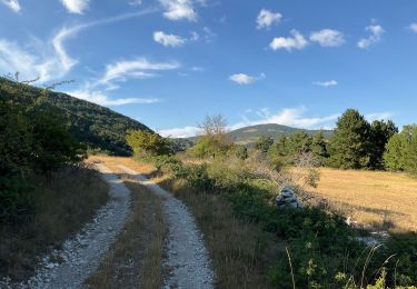
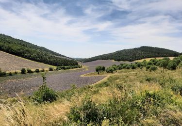
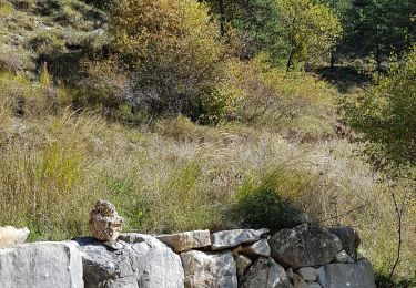
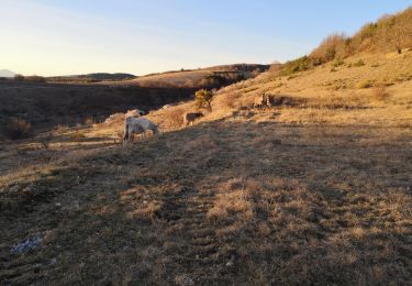
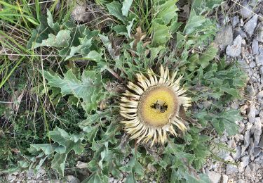
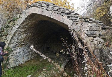
Randonnée Marche de 5,5 km à découvrir à Provence-Alpes-Côte d'Azur, Alpes-de-Haute-Provence, Redortiers. Cette randonnée est proposée par ANDREJAC.
Description
Départ et retour du Y entre Les Martins et Tinette
Montée par le GRP Tour de la Montagne de Lure, retour par la crète Coulet du Bastard.
Localisation
Pays :
France
Région :
Provence-Alpes-Côte d'Azur
Département/Province :
Alpes-de-Haute-Provence
Commune :
Redortiers
Localité :
Unknown
Départ:(Dec)
Départ:(UTM)
710022 ; 4888069 (31T) N.
Commentaires
Randonnées à proximité
![Randonnée Marche La Rochegiron - larochegiron.fon martine - Photo](https://media.geolcdn.com/t/375/260/930a888f-876d-4f7e-b713-2559d56cf7a6.jpg&format=jpg&maxdim=2)
![Marche Marche](https://static1.geolcdn.com/sitytour/trail-icons/101.png)
larochegiron.fon martine
Marche
Moyen
La Rochegiron,
Provence-Alpes-Côte d'Azur,
Alpes-de-Haute-Provence,
France
![](/images/other/stat-length.png)
8,7 km | 12,6 km-effort
3h 51min
![](https://static1.geolcdn.com/siteimages/upload/files/16400158638029165_repeat_loop_refresh_sync_direction_icon.png)
Oui
![Randonnée Marche La Rochegiron - la rochegiron 04.fon Martine, la blanchere, veire - Photo](https://media.geolcdn.com/t/375/260/1cfdc527-2f27-4eb2-bfbb-ee96eaef5c73.jpg&format=jpg&maxdim=2)
![Marche Marche](https://static1.geolcdn.com/sitytour/trail-icons/101.png)
la rochegiron 04.fon Martine, la blanchere, veire
Marche
Moyen
La Rochegiron,
Provence-Alpes-Côte d'Azur,
Alpes-de-Haute-Provence,
France
![](/images/other/stat-length.png)
8,7 km | 12,4 km-effort
2h 52min
![](https://static1.geolcdn.com/siteimages/upload/files/16400158638029165_repeat_loop_refresh_sync_direction_icon.png)
Oui
![Randonnée Marche La Rochegiron - la rochegiron. vievre. la blanchete - Photo](https://media.geolcdn.com/t/375/260/bfaf4d1e-65c1-4c56-9e95-1797ce68b20c.jpg&format=jpg&maxdim=2)
![Marche Marche](https://static1.geolcdn.com/sitytour/trail-icons/101.png)
la rochegiron. vievre. la blanchete
Marche
Moyen
La Rochegiron,
Provence-Alpes-Côte d'Azur,
Alpes-de-Haute-Provence,
France
![](/images/other/stat-length.png)
10,1 km | 14,3 km-effort
3h 44min
![](https://static1.geolcdn.com/siteimages/upload/files/16400158638029165_repeat_loop_refresh_sync_direction_icon.png)
Oui
![Randonnée Marche La Rochegiron - Vières - Font Martine - La Blanchère - Photo](https://media.geolcdn.com/t/375/260/11934e5f-69db-4fb3-83fc-2ceab7fd3723.jpg&format=jpg&maxdim=2)
![Marche Marche](https://static1.geolcdn.com/sitytour/trail-icons/101.png)
Vières - Font Martine - La Blanchère
Marche
Facile
La Rochegiron,
Provence-Alpes-Côte d'Azur,
Alpes-de-Haute-Provence,
France
![](/images/other/stat-length.png)
9 km | 12 km-effort
2h 26min
![](https://static1.geolcdn.com/siteimages/upload/files/16400158638029165_repeat_loop_refresh_sync_direction_icon.png)
Oui
![Randonnée Marche Les Omergues - Saint André de villeseche. la pyramide du moine - Photo](https://media.geolcdn.com/t/375/260/f0d3a24b-5790-4360-ba83-c34cca9fe40d.jpg&format=jpg&maxdim=2)
![Marche Marche](https://static1.geolcdn.com/sitytour/trail-icons/101.png)
Saint André de villeseche. la pyramide du moine
Marche
Moyen
Les Omergues,
Provence-Alpes-Côte d'Azur,
Alpes-de-Haute-Provence,
France
![](/images/other/stat-length.png)
10 km | 13,6 km-effort
4h 0min
![](https://static1.geolcdn.com/siteimages/upload/files/16400158638029165_repeat_loop_refresh_sync_direction_icon.png)
Oui
![Randonnée Marche La Rochegiron - 04 - VIERE, la Font Martine - Photo](https://media.geolcdn.com/t/375/260/84b6cfc9-fb1b-485b-99ea-25c8e3e1a886.jpg&format=jpg&maxdim=2)
![Marche Marche](https://static1.geolcdn.com/sitytour/trail-icons/101.png)
04 - VIERE, la Font Martine
Marche
Facile
La Rochegiron,
Provence-Alpes-Côte d'Azur,
Alpes-de-Haute-Provence,
France
![](/images/other/stat-length.png)
7,9 km | 11,6 km-effort
2h 30min
![](https://static1.geolcdn.com/siteimages/upload/files/16400158638029165_repeat_loop_refresh_sync_direction_icon.png)
Oui
![Randonnée Marche Redortiers - Bergeries du Contadour. (25-12-18). - Photo](https://media.geolcdn.com/t/375/260/ext.jpg?maxdim=2&url=https%3A%2F%2Fservices.sitytrail.com%2FGeolivesWS%2FDownloadMedia.ashx%3FTrailID%3D1088146%26Media%3Dfix__20181225162928.jpg)
![Marche Marche](https://static1.geolcdn.com/sitytour/trail-icons/101.png)
Bergeries du Contadour. (25-12-18).
Marche
Moyen
Redortiers,
Provence-Alpes-Côte d'Azur,
Alpes-de-Haute-Provence,
France
![](/images/other/stat-length.png)
13,2 km | 17,7 km-effort
2h 55min
![](https://static1.geolcdn.com/siteimages/upload/files/16400158638029165_repeat_loop_refresh_sync_direction_icon.png)
Non
![Randonnée Marche La Rochegiron - Petite balade depuis le Jonquet (La Rochegiron - 04) - Photo](https://media.geolcdn.com/t/375/260/bde98790-8d9a-47e0-960c-1b93e4595e80.jpg&format=jpg&maxdim=2)
![Marche Marche](https://static1.geolcdn.com/sitytour/trail-icons/101.png)
Petite balade depuis le Jonquet (La Rochegiron - 04)
Marche
Facile
La Rochegiron,
Provence-Alpes-Côte d'Azur,
Alpes-de-Haute-Provence,
France
![](/images/other/stat-length.png)
4 km | 5,9 km-effort
1h 18min
![](https://static1.geolcdn.com/siteimages/upload/files/16400158638029165_repeat_loop_refresh_sync_direction_icon.png)
Non
![Randonnée Marche Redortiers - autour du vieux Redortiers ( Aubignane) - Photo](https://media.geolcdn.com/t/375/260/26207229-8d38-44b3-9b66-e068cc1865cb.jpg&format=jpg&maxdim=2)
![Marche Marche](https://static1.geolcdn.com/sitytour/trail-icons/101.png)
autour du vieux Redortiers ( Aubignane)
Marche
Moyen
Redortiers,
Provence-Alpes-Côte d'Azur,
Alpes-de-Haute-Provence,
France
![](/images/other/stat-length.png)
7 km | 9,7 km-effort
3h 28min
![](https://static1.geolcdn.com/siteimages/upload/files/16400158638029165_repeat_loop_refresh_sync_direction_icon.png)
Oui