Randonnée Marche Senantes - Senantes - le chemin de la source - Photo

Senantes - le chemin de la source

 marcel.F
marcel.F

Utilisateur

© OpenStreetMap contributors
Longueur
Longueur
12,7 km
Altitude max
Altitude max
195 m
Dénivelé positif
Dénivelé positif
185 m
Km-Effort
Km-Effort  
15,2 km
Altitude min
Altitude min
111 m
Dénivelé négatif
Dénivelé négatif
184 m
Boucle
Boucle
Oui
Date de création :
2019-04-01 20:25:57.603
Dernière modification :
2019-04-01 20:25:57.75

(0 Avis)

Marche
Marche
3h19
Difficulté : Facile

Scannez ce code QR pour ouvrir la randonnée dans l'application SityTrail

Application GPS de randonnée GRATUITE

Logo SityTrail SityTrail

IGN / Instituts géographiques

Télécharger SityTrail sur l'App Store Télécharger SityTrail sur Google Play

Logo SityTrail SityTrail World

Le monde est à vous

Télécharger SityTrail sur l'App Store Télécharger SityTrail sur Google Play Télécharger SityTrail sur Huawei AppGallery

À propos

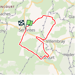
Randonnée Marche de 12,7 km à découvrir à Hauts-de-France, Oise, Senantes. Cette randonnée est proposée par marcel.F.

Description

Départ parking de l'église de Senantes

Profil altimétrique

Localisation

Pays :
France
Région :
Hauts-de-France
Département/Province :
Oise
Commune :
Senantes
Localité :
Unknown
Départ:(Dec)
Départ:(UTM)
415660 ; 5482158 (31U) N.

Randonnées à proximité

Randonnée V.T.T. Lachapelle-aux-Pots - la Chapelle aux Pots - Savignie - Photo
V.T.T.
sebcar

V.T.T.

Moyen
(1)
Lachapelle-aux-Pots, Hauts-de-France, Oise, France
19,1 km | 24 km-effort
1h 39min
Oui
Randonnée Marche Hanvoile - 20200903-Gerberoy - Photo
Marche
doudet

Marche

Moyen
Hanvoile, Hauts-de-France, Oise, France
24 km | 29 km-effort
6h 59min
Oui
Randonnée Marche Senantes - Senantes - Photo
Marche
jpblimond

Marche

Moyen
Senantes, Hauts-de-France, Oise, France
18,7 km | 23 km-effort
4h 47min
Oui
Randonnée Marche Saint-Germer-de-Fly - Saint Germer de Fly - Mont de Fly - 8.6 km - Photo
Marche
Marie-Claire-mcp

Marche

Moyen
Saint-Germer-de-Fly, Hauts-de-France, Oise, France
8,6 km | 10,5 km-effort
2h 23min
Oui
Randonnée A pied Gerberoy - gerberoy - Photo
A pied
nicole.reine@wanadoo.fr

A pied

Facile
Gerberoy, Hauts-de-France, Oise, France
6,3 km | 8 km-effort
1h 49min
Oui
Randonnée Marche Villers-sur-Auchy - Villers-sur-Auchy  - Photo
Marche
jpblimond

Marche

Moyen
Villers-sur-Auchy, Hauts-de-France, Oise, France
18,1 km | 22 km-effort
4h 11min
Oui
Randonnée Marche Lachapelle-aux-Pots - Lachapelle-aux-pots - Héricourt - La Frénoye - Armentières - Photo
Marche
Marie-Claire-mcp

Marche

Difficile
Lachapelle-aux-Pots, Hauts-de-France, Oise, France
10,7 km | 13,7 km-effort
3h 6min
Oui
Randonnée Marche Lachapelle-aux-Pots - Lachapelle aux pots - Armentières 11 km - Photo
Marche
Marie-Claire-mcp

Marche

Difficile
Lachapelle-aux-Pots, Hauts-de-France, Oise, France
10,6 km | 13,5 km-effort
3h 4min
Oui
Randonnée Marche Lachapelle-aux-Pots - Lachapelle aux Pots - Rando santé 1 - Photo
Marche
marcel.F

Marche

Moyen
Lachapelle-aux-Pots, Hauts-de-France, Oise, France
5,6 km | 6,4 km-effort
1h 24min
Oui


Fermer
Mes abonnements