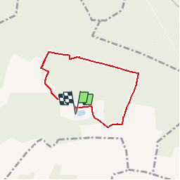
![](/images/other/stat-length.png)
![Randonnée Marche Luzarches - L'abbaye d'Herivaux _6,1 km - Photo](https://media.geolcdn.com/t/1900/400/ext.pjpeg?maxdim=2&url=https%3A%2F%2Fstatic1.geolcdn.com%2Fsiteimages%2Fupload%2Ffiles%2F1553511878bg_sport_marche.png)
L'abbaye d'Herivaux _6,1 km
Pousscailleux
Utilisateur
![Longueur](/images/other/stat-length.png)
![Altitude max](https://static1.geolcdn.com/siteimages/upload/files/1508320355ic_sort_altitude_max_24dp.png)
![Dénivelé positif](https://static1.geolcdn.com/siteimages/upload/files/1508320355ic_sort_den_pos_24dp.png)
![Km-Effort](/images/other/stat-length.png)
![Altitude min](https://static1.geolcdn.com/siteimages/upload/files/1508320355ic_sort_altitude_min_24dp.png)
![Dénivelé négatif](https://static1.geolcdn.com/siteimages/upload/files/1508320355ic_sort_den_neg_24dp.png)
![Boucle](https://static1.geolcdn.com/siteimages/upload/files/16400158638029165_repeat_loop_refresh_sync_direction_icon.png)
![Marche](https://static1.geolcdn.com/sitytour/trail-icons/101.png)
1h39
Difficulté : Facile
![Scannez ce code QR pour ouvrir la randonnée dans l'application SityTrail](https://capi.geolives.com/qq0zvz2zws4bq2lad0pu/sitytour/trails/223295/qr.png?size=200)
Application GPS de randonnée GRATUITE
À propos
Randonnée Marche de 6,1 km à découvrir à Île-de-France, Val-d'Oise, Luzarches. Cette randonnée est proposée par Pousscailleux.
Description
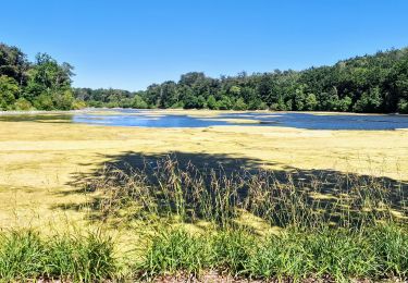
Se garer sur le bord du chemin au niveau de l'étang d'Hérivaux.
Le site abrita une Abbaye construite sur un ermitage bien plus ancien. En partie détruite lors de la Révolution Française, l’ancienne abbaye fut rachetée le 1er novembre 1796 par Benjamin Constant qui fait aménager une aile des annexes préservée de la destruction. Celle-ci servira de base au futur Château. Il le revendra en 1802. Il y rédigea "Des réactions politiques" et "des effets de la Terreur". Germaine de Staël y séjourna plusieurs mois de décembre 1796 à juin 1798. Depuis, il est resté une propriété privée et a été divisé en plusieurs habitations.
Localisation
Commentaires
Randonnées à proximité
![Randonnée Marche Orry-la-Ville - Dans la forêt des moines - Orry-la-Ville - Photo](https://media.geolcdn.com/t/375/260/ext.jpg?maxdim=2&url=https%3A%2F%2Fservices.sitytrail.com%2FGeolivesWS%2FDownloadMedia.ashx%3FTrailID%3D112753%26Media%3D11974_6.jpg)
![Marche Marche](https://static1.geolcdn.com/sitytour/trail-icons/101.png)
Marche
![](/images/other/stat-length.png)
![](https://static1.geolcdn.com/siteimages/upload/files/16400158638029165_repeat_loop_refresh_sync_direction_icon.png)
![Randonnée Marche Coye-la-Forêt - SM_COYE la FORET_7.9Km - Photo](https://media.geolcdn.com/t/375/260/2c7f88d5-a8c7-4a01-b898-2562006c8bcb.jpg&format=jpg&maxdim=2)
![Marche Marche](https://static1.geolcdn.com/sitytour/trail-icons/101.png)
Marche
![](/images/other/stat-length.png)
![](https://static1.geolcdn.com/siteimages/upload/files/16400158638029165_repeat_loop_refresh_sync_direction_icon.png)
![Randonnée Marche Orry-la-Ville - SM_MONTGRESIN_EST_8.2Km - Photo](https://media.geolcdn.com/t/375/260/311cd4bc-107d-4955-a31f-0f6e6e4d5e34.jpg&format=jpg&maxdim=2)
![Marche Marche](https://static1.geolcdn.com/sitytour/trail-icons/101.png)
Marche
![](/images/other/stat-length.png)
![](https://static1.geolcdn.com/siteimages/upload/files/16400158638029165_repeat_loop_refresh_sync_direction_icon.png)
![Randonnée Marche Luzarches - Autour d'Orry la Ville - Photo](https://media.geolcdn.com/t/375/260/ext.jpg?maxdim=2&url=https%3A%2F%2Fservices.sitytrail.com%2FGeolivesWS%2FDownloadMedia.ashx%3FTrailID%3D110190%26Media%3D5411_1.jpg)
![Marche Marche](https://static1.geolcdn.com/sitytour/trail-icons/101.png)
Marche
![](/images/other/stat-length.png)
![](https://static1.geolcdn.com/siteimages/upload/files/16400158638029165_repeat_loop_refresh_sync_direction_icon.png)
![Randonnée Marche Orry-la-Ville - La forêt des étangs de Comelle - Orry la Ville - Photo](https://media.geolcdn.com/t/375/260/ext.jpg?maxdim=2&url=https%3A%2F%2Fservices.sitytrail.com%2FGeolivesWS%2FDownloadMedia.ashx%3FTrailID%3D106559%26Media%3D11129_1.jpg)
![Marche Marche](https://static1.geolcdn.com/sitytour/trail-icons/101.png)
Marche
![](/images/other/stat-length.png)
![](https://static1.geolcdn.com/siteimages/upload/files/16400158638029165_repeat_loop_refresh_sync_direction_icon.png)
![Randonnée Marche Fosses - Boucle Survilliers - St Witz - Moussy le neuf - Plailly 25 km - Photo](https://media.geolcdn.com/t/375/260/6acc754b-b0c4-4c8e-9dba-f497fb8b1c3a.jpg&format=jpg&maxdim=2)
![Marche Marche](https://static1.geolcdn.com/sitytour/trail-icons/101.png)
Marche
![](/images/other/stat-length.png)
![](https://static1.geolcdn.com/siteimages/upload/files/16400158638029165_repeat_loop_refresh_sync_direction_icon.png)
![Randonnée Marche Orry-la-Ville - FORET DE COYE 17KM - Photo](https://media.geolcdn.com/t/375/260/ext.jpg?maxdim=2&url=https%3A%2F%2Fstatic1.geolcdn.com%2Fsiteimages%2Fupload%2Ffiles%2F1553511878bg_sport_marche.png)
![Marche Marche](https://static1.geolcdn.com/sitytour/trail-icons/101.png)
Marche
![](/images/other/stat-length.png)
![](https://static1.geolcdn.com/siteimages/upload/files/16400158638029165_repeat_loop_refresh_sync_direction_icon.png)
![Randonnée Marche Coye-la-Forêt - Boucle autour des étangs de Commelles - Photo](https://media.geolcdn.com/t/375/260/6a2603b8-9a9b-4181-bd6f-9bbd4d84b309.jpg&format=jpg&maxdim=2)
![Marche Marche](https://static1.geolcdn.com/sitytour/trail-icons/101.png)
Marche
![](/images/other/stat-length.png)
![](https://static1.geolcdn.com/siteimages/upload/files/16400158638029165_repeat_loop_refresh_sync_direction_icon.png)
![Randonnée Marche Orry-la-Ville - Le tour du grand paris via le GR1 Etape 8 Coye - Dammartin - Photo](https://media.geolcdn.com/t/375/260/8216a67e-3c89-4e98-bafa-ff3f69813906.jpeg&format=jpg&maxdim=2)
![Marche Marche](https://static1.geolcdn.com/sitytour/trail-icons/101.png)
Marche
![](/images/other/stat-length.png)
![](https://static1.geolcdn.com/siteimages/upload/files/16400158638029165_repeat_loop_refresh_sync_direction_icon.png)
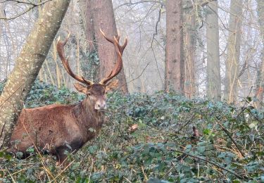
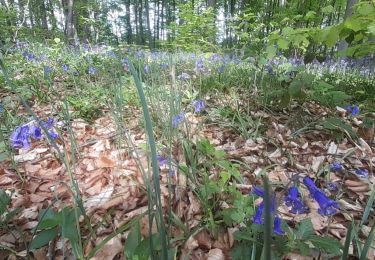
balade familliale, secteur avec beaucoup de gibier ...