![](/images/other/stat-length.png)
![Randonnée Autre activité Urnäsch - Urnäsch - Wattwil - Photo](https://media.geolcdn.com/t/1900/400/ext.pjpeg?maxdim=2&url=https%3A%2F%2Fstatic1.geolcdn.com%2Fsiteimages%2Fupload%2Ffiles%2F1545311037marcheuse_200dpi.jpg)
Urnäsch - Wattwil
hallauer
Utilisateur
![Longueur](/images/other/stat-length.png)
Longueur
19,6 km
![Altitude max](https://static1.geolcdn.com/siteimages/upload/files/1508320355ic_sort_altitude_max_24dp.png)
Altitude max
1135 m
![Dénivelé positif](https://static1.geolcdn.com/siteimages/upload/files/1508320355ic_sort_den_pos_24dp.png)
Dénivelé positif
734 m
![Km-Effort](/images/other/stat-length.png)
Km-Effort
30 km
![Altitude min](https://static1.geolcdn.com/siteimages/upload/files/1508320355ic_sort_altitude_min_24dp.png)
Altitude min
611 m
![Dénivelé négatif](https://static1.geolcdn.com/siteimages/upload/files/1508320355ic_sort_den_neg_24dp.png)
Dénivelé négatif
945 m
![Boucle](https://static1.geolcdn.com/siteimages/upload/files/16400158638029165_repeat_loop_refresh_sync_direction_icon.png)
Boucle
Non
Date de création :
2014-12-11 00:00:00.0
Dernière modification :
2014-12-11 00:00:00.0
![Autre activité](https://static1.geolcdn.com/sitytour/trail-icons/900.png)
--
Difficulté : Inconnu
![Scannez ce code QR pour ouvrir la randonnée dans l'application SityTrail](https://capi.geolives.com/qq0zvz2zws4bq2lad0pu/sitytour/trails/22326/qr.png?size=200)
Application GPS de randonnée GRATUITE
À propos
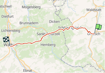
Randonnée Autre activité de 19,6 km à découvrir à Appenzell Rhodes-Extérieures, Hinterland, Urnäsch. Cette randonnée est proposée par hallauer.
Description
Der Pilgerweg führt zu Teilen über die "SwissMobil-Routen 44 und 4" Appenzellerweg und Via Jacobi
Localisation
Pays :
Suisse
Région :
Appenzell Rhodes-Extérieures
Département/Province :
Hinterland
Commune :
Urnäsch
Localité :
Unknown
Départ:(Dec)
Départ:(UTM)
521604 ; 5240581 (32T) N.
Commentaires
Randonnées à proximité
![Randonnée A pied Urnäsch - Blattendürren-Kronberg - Photo](https://media.geolcdn.com/t/375/260/a2016e78-e952-4e3a-8e2f-b7aaa12ac8b0.jpeg&format=jpg&maxdim=2)
![A pied A pied](https://static1.geolcdn.com/sitytour/trail-icons/100.png)
Blattendürren-Kronberg
A pied
Facile
Urnäsch,
Appenzell Rhodes-Extérieures,
Hinterland,
Suisse
![](/images/other/stat-length.png)
6,1 km | 15,7 km-effort
3h 33min
![](https://static1.geolcdn.com/siteimages/upload/files/16400158638029165_repeat_loop_refresh_sync_direction_icon.png)
Non
![Randonnée A pied Urnäsch - CH-Schönau-Berggasthaus Hochhamm-Parkplatz Hochhamm - Photo](https://media.geolcdn.com/t/375/260/029ba061-1981-4534-b5d6-9d170dcffbbc.jpeg&format=jpg&maxdim=2)
![A pied A pied](https://static1.geolcdn.com/sitytour/trail-icons/100.png)
CH-Schönau-Berggasthaus Hochhamm-Parkplatz Hochhamm
A pied
Facile
Urnäsch,
Appenzell Rhodes-Extérieures,
Hinterland,
Suisse
![](/images/other/stat-length.png)
3,1 km | 6,1 km-effort
1h 23min
![](https://static1.geolcdn.com/siteimages/upload/files/16400158638029165_repeat_loop_refresh_sync_direction_icon.png)
Non
![Randonnée A pied Urnäsch - Grüenau-Herrendürren - Photo](https://media.geolcdn.com/t/375/260/ext.jpg?maxdim=2&url=https%3A%2F%2Fstatic1.geolcdn.com%2Fsiteimages%2Fupload%2Ffiles%2F1545311037marcheuse_200dpi.jpg)
![A pied A pied](https://static1.geolcdn.com/sitytour/trail-icons/100.png)
Grüenau-Herrendürren
A pied
Facile
Urnäsch,
Appenzell Rhodes-Extérieures,
Hinterland,
Suisse
![](/images/other/stat-length.png)
3,3 km | 7 km-effort
1h 35min
![](https://static1.geolcdn.com/siteimages/upload/files/16400158638029165_repeat_loop_refresh_sync_direction_icon.png)
Non
![Randonnée A pied Hundwil - Gonten - Hundwilerhöhe - Photo](https://media.geolcdn.com/t/375/260/ext.jpg?maxdim=2&url=https%3A%2F%2Fstatic1.geolcdn.com%2Fsiteimages%2Fupload%2Ffiles%2F1545311037marcheuse_200dpi.jpg)
![A pied A pied](https://static1.geolcdn.com/sitytour/trail-icons/100.png)
Gonten - Hundwilerhöhe
A pied
Facile
Hundwil,
Appenzell Rhodes-Extérieures,
Hinterland,
Suisse
![](/images/other/stat-length.png)
3,2 km | 4,7 km-effort
1h 3min
![](https://static1.geolcdn.com/siteimages/upload/files/16400158638029165_repeat_loop_refresh_sync_direction_icon.png)
Non
![Randonnée Marche Urnäsch - sf_e2b - Photo](https://media.geolcdn.com/t/375/260/ext.jpg?maxdim=2&url=https%3A%2F%2Fstatic1.geolcdn.com%2Fsiteimages%2Fupload%2Ffiles%2F1553511878bg_sport_marche.png)
![Marche Marche](https://static1.geolcdn.com/sitytour/trail-icons/101.png)
sf_e2b
Marche
Très facile
Urnäsch,
Appenzell Rhodes-Extérieures,
Hinterland,
Suisse
![](/images/other/stat-length.png)
12,9 km | 26 km-effort
4h 32min
![](https://static1.geolcdn.com/siteimages/upload/files/16400158638029165_repeat_loop_refresh_sync_direction_icon.png)
Non
![Randonnée Autre activité Schwellbrunn - Schwellbrunn - Wattwil - Photo](https://media.geolcdn.com/t/375/260/ext.jpg?maxdim=2&url=https%3A%2F%2Fstatic1.geolcdn.com%2Fsiteimages%2Fupload%2Ffiles%2F1545311037marcheuse_200dpi.jpg)
![Autre activité Autre activité](https://static1.geolcdn.com/sitytour/trail-icons/900.png)
Schwellbrunn - Wattwil
Autre activité
Très facile
Schwellbrunn,
Appenzell Rhodes-Extérieures,
Hinterland,
Suisse
![](/images/other/stat-length.png)
16,2 km | 25 km-effort
Inconnu
![](https://static1.geolcdn.com/siteimages/upload/files/16400158638029165_repeat_loop_refresh_sync_direction_icon.png)
Non
![Randonnée Autre activité Schönengrund - JW Urnäsch-Wattwil REG Teil 2 - Photo](https://media.geolcdn.com/t/375/260/ext.jpg?maxdim=2&url=https%3A%2F%2Fstatic1.geolcdn.com%2Fsiteimages%2Fupload%2Ffiles%2F1545311037marcheuse_200dpi.jpg)
![Autre activité Autre activité](https://static1.geolcdn.com/sitytour/trail-icons/900.png)
JW Urnäsch-Wattwil REG Teil 2
Autre activité
Très facile
Schönengrund,
Appenzell Rhodes-Extérieures,
Hinterland,
Suisse
![](/images/other/stat-length.png)
5 km | 6,4 km-effort
Inconnu
![](https://static1.geolcdn.com/siteimages/upload/files/16400158638029165_repeat_loop_refresh_sync_direction_icon.png)
Non
![Randonnée Autre activité Urnäsch - JW Urnäsch-Wattwil REG Teil 1 - Photo](https://media.geolcdn.com/t/375/260/ext.jpg?maxdim=2&url=https%3A%2F%2Fstatic1.geolcdn.com%2Fsiteimages%2Fupload%2Ffiles%2F1545311037marcheuse_200dpi.jpg)
![Autre activité Autre activité](https://static1.geolcdn.com/sitytour/trail-icons/900.png)
JW Urnäsch-Wattwil REG Teil 1
Autre activité
Très facile
Urnäsch,
Appenzell Rhodes-Extérieures,
Hinterland,
Suisse
![](/images/other/stat-length.png)
4,2 km | 7,9 km-effort
Inconnu
![](https://static1.geolcdn.com/siteimages/upload/files/16400158638029165_repeat_loop_refresh_sync_direction_icon.png)
Non
![Randonnée Autre activité Gonten - JW Eggerstanden-Urnäsch Teil 4 - Photo](https://media.geolcdn.com/t/375/260/ext.jpg?maxdim=2&url=https%3A%2F%2Fstatic1.geolcdn.com%2Fsiteimages%2Fupload%2Ffiles%2F1545311037marcheuse_200dpi.jpg)
![Autre activité Autre activité](https://static1.geolcdn.com/sitytour/trail-icons/900.png)
JW Eggerstanden-Urnäsch Teil 4
Autre activité
Très facile
Gonten,
Appenzell Rhodes-Intérieures,
Inconnu,
Suisse
![](/images/other/stat-length.png)
3,9 km | 6,4 km-effort
Inconnu
![](https://static1.geolcdn.com/siteimages/upload/files/16400158638029165_repeat_loop_refresh_sync_direction_icon.png)
Non