![](/images/other/stat-length.png)
![Randonnée Marche Sickert - Sickert - Photo](https://media.geolcdn.com/t/1900/400/34397ca7-9519-4a2c-a004-e8e6098fe92a.jpg&format=pjpeg&maxdim=2)
Sickert
helmut68
Utilisateur
![Longueur](/images/other/stat-length.png)
![Altitude max](https://static1.geolcdn.com/siteimages/upload/files/1508320355ic_sort_altitude_max_24dp.png)
![Dénivelé positif](https://static1.geolcdn.com/siteimages/upload/files/1508320355ic_sort_den_pos_24dp.png)
![Km-Effort](/images/other/stat-length.png)
![Altitude min](https://static1.geolcdn.com/siteimages/upload/files/1508320355ic_sort_altitude_min_24dp.png)
![Dénivelé négatif](https://static1.geolcdn.com/siteimages/upload/files/1508320355ic_sort_den_neg_24dp.png)
![Boucle](https://static1.geolcdn.com/siteimages/upload/files/16400158638029165_repeat_loop_refresh_sync_direction_icon.png)
![Marche](https://static1.geolcdn.com/sitytour/trail-icons/101.png)
2h41
Difficulté : Facile
![Scannez ce code QR pour ouvrir la randonnée dans l'application SityTrail](https://capi.geolives.com/qq0zvz2zws4bq2lad0pu/sitytour/trails/2232271/qr.png?size=200)
Application GPS de randonnée GRATUITE
À propos
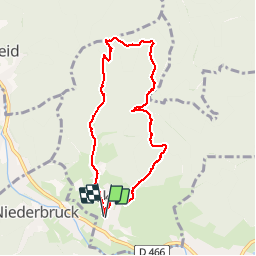
Randonnée Marche de 7,6 km à découvrir à Grand Est, Haut-Rhin, Sickert. Cette randonnée est proposée par helmut68.
Description
Départ place de la mairie et de l'église de Sickert puis suivre le balisage "disque bleu " jusqu'à l'abri " Gaugler " où vous pourrez passer un moment agréable ( détente , repas ,...etc ).
Au départ de l'abri empruntez le balisage " rectangle jaune blanc jaune " puis le balisage " triangle rouge " jusqu'au Luttersberg . N'oubliez pas le point de vue du " Rocher de la Croix " vous pourrez admirer la belle vallée de la Doller .Pour finir utilisez le balisage " anneau rouge" jusqu'à la Kutzakapalala ( chapelle ) et Sickert.
Localisation
Commentaires
Randonnées à proximité
![Randonnée Marche Masevaux-Niederbruck - Masevaux - Rossberg par le belvédère du Fuchsfelsen - Photo](https://media.geolcdn.com/t/375/260/d9cc765c-1250-4953-9d9f-fb8b88eb82a7.jpg&format=jpg&maxdim=2)
![Marche Marche](https://static1.geolcdn.com/sitytour/trail-icons/101.png)
Marche
![](/images/other/stat-length.png)
![](https://static1.geolcdn.com/siteimages/upload/files/16400158638029165_repeat_loop_refresh_sync_direction_icon.png)
![Randonnée Marche Rimbach-près-Masevaux - Haute Bers - Photo](https://media.geolcdn.com/t/375/260/263a149f-9c7c-4184-802a-631c78ca66f6.jpg&format=jpg&maxdim=2)
![Marche Marche](https://static1.geolcdn.com/sitytour/trail-icons/101.png)
Marche
![](/images/other/stat-length.png)
![](https://static1.geolcdn.com/siteimages/upload/files/16400158638029165_repeat_loop_refresh_sync_direction_icon.png)
![Randonnée Marche Dolleren - 2025-01-02 Rando Polaire Dolleren Ballon Alsace Etape 1 - Photo](https://media.geolcdn.com/t/375/260/98b6c1e4-75f0-464a-86a1-edc427e75210.jpg&format=jpg&maxdim=2)
![Marche Marche](https://static1.geolcdn.com/sitytour/trail-icons/101.png)
Marche
![](/images/other/stat-length.png)
![](https://static1.geolcdn.com/siteimages/upload/files/16400158638029165_repeat_loop_refresh_sync_direction_icon.png)
![Randonnée Marche Bourbach-le-Haut - Tour du Rossberg - Gsang - Thannerhubel - Photo](https://media.geolcdn.com/t/375/260/d4089ace-97e6-4d95-86a3-a999ece263d3.jpg&format=jpg&maxdim=2)
![Marche Marche](https://static1.geolcdn.com/sitytour/trail-icons/101.png)
Marche
![](/images/other/stat-length.png)
![](https://static1.geolcdn.com/siteimages/upload/files/16400158638029165_repeat_loop_refresh_sync_direction_icon.png)
![Randonnée Marche Kirchberg - 2022-07-15 Marche Refuge Baerenkopf Auberge Gazon Vert - Photo](https://media.geolcdn.com/t/375/260/d5c191fc-95a3-4bb1-8368-e694339cee76.jpg&format=jpg&maxdim=2)
![Marche Marche](https://static1.geolcdn.com/sitytour/trail-icons/101.png)
Marche
![](/images/other/stat-length.png)
![](https://static1.geolcdn.com/siteimages/upload/files/16400158638029165_repeat_loop_refresh_sync_direction_icon.png)
![Randonnée Marche Lauw - 2022-07-14 Marche Lauw Refuge CAF Baerenkopf - Photo](https://media.geolcdn.com/t/375/260/e2209d17-65ac-46f6-a404-5274e10a843e.jpg&format=jpg&maxdim=2)
![Marche Marche](https://static1.geolcdn.com/sitytour/trail-icons/101.png)
Marche
![](/images/other/stat-length.png)
![](https://static1.geolcdn.com/siteimages/upload/files/16400158638029165_repeat_loop_refresh_sync_direction_icon.png)
![Randonnée A pied Sentheim - Sentheim - Bergwald - Eichwald - Guevenheim - Sentheim - Photo](https://media.geolcdn.com/t/375/260/ext.jpg?maxdim=2&url=https%3A%2F%2Fstatic1.geolcdn.com%2Fsiteimages%2Fupload%2Ffiles%2F1545311037marcheuse_200dpi.jpg)
![A pied A pied](https://static1.geolcdn.com/sitytour/trail-icons/100.png)
A pied
![](/images/other/stat-length.png)
![](https://static1.geolcdn.com/siteimages/upload/files/16400158638029165_repeat_loop_refresh_sync_direction_icon.png)
![Randonnée Marche Bitschwiller-lès-Thann - 68 Col du Hundsrück - FA Gsang - retour ThannerHubel - Photo](https://media.geolcdn.com/t/375/260/ext.jpg?maxdim=2&url=https%3A%2F%2Fstatic1.geolcdn.com%2Fsiteimages%2Fupload%2Ffiles%2F1553511878bg_sport_marche.png)
![Marche Marche](https://static1.geolcdn.com/sitytour/trail-icons/101.png)
Marche
![](/images/other/stat-length.png)
![](https://static1.geolcdn.com/siteimages/upload/files/16400158638029165_repeat_loop_refresh_sync_direction_icon.png)
![Randonnée Marche Masevaux-Niederbruck - Reco avec ALAIN..Rando CLAS du 29/08/2024 - Photo](https://media.geolcdn.com/t/375/260/5dba7985-af1b-4076-a275-05f9cb5145f8.jpg&format=jpg&maxdim=2)
![Marche Marche](https://static1.geolcdn.com/sitytour/trail-icons/101.png)
Marche
![](/images/other/stat-length.png)
![](https://static1.geolcdn.com/siteimages/upload/files/16400158638029165_repeat_loop_refresh_sync_direction_icon.png)