Randonnée Marche Saint-Jean-Cap-Ferrat - Tour de Saint Jean Cap Ferrat et Saint Hospice - Photo

Tour de Saint Jean Cap Ferrat et Saint Hospice

 ETMU5496
ETMU5496

Utilisateur

© OpenStreetMap contributors
Longueur
Longueur
12,8 km
Altitude max
Altitude max
49 m
Dénivelé positif
Dénivelé positif
256 m
Km-Effort
Km-Effort  
16,2 km
Altitude min
Altitude min
-1 m
Dénivelé négatif
Dénivelé négatif
256 m
Boucle
Boucle
Oui
Date de création :
2019-10-16 09:42:24.0
Dernière modification :
2019-10-17 07:40:47.304

(1 Avis)

Marche
Marche
3h28
Difficulté : Inconnu

Scannez ce code QR pour ouvrir la randonnée dans l'application SityTrail

Application GPS de randonnée GRATUITE

Logo SityTrail SityTrail

IGN / Instituts géographiques

Télécharger SityTrail sur l'App Store Télécharger SityTrail sur Google Play

Logo SityTrail SityTrail World

Le monde est à vous

Télécharger SityTrail sur l'App Store Télécharger SityTrail sur Google Play Télécharger SityTrail sur Huawei AppGallery

À propos

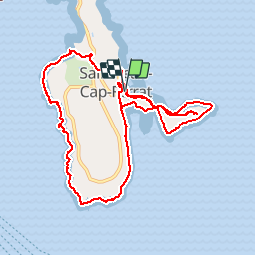
Randonnée Marche de 12,8 km à découvrir à Provence-Alpes-Côte d'Azur, Alpes-Maritimes, Saint-Jean-Cap-Ferrat. Cette randonnée est proposée par ETMU5496.

Description

Jolie randonnée autour du Cap Ferrat (port, Pointe Ste Hospice, le sentier littoral) achevée par la visite de la superbe Chapelle Ste Hospice ornée d'une grandiose madone

Profil altimétrique

Photos

Localisation

Pays :
France
Région :
Provence-Alpes-Côte d'Azur
Département/Province :
Alpes-Maritimes
Commune :
Saint-Jean-Cap-Ferrat
Localité :
Unknown
Départ:(UTM)
365771 ; 4838656 (32T) N.

Commentaires

Veuillez vous connecter pour laisser un commentaire ou une note


Randonnées à proximité

Randonnée Marche Nice - Ballade chemin des douaniers Nice-Villefranche  - Photo
Marche
coriace

Marche

Très facile
(1)
Nice, Provence-Alpes-Côte d'Azur, Alpes-Maritimes, France
7,9 km | 10,3 km-effort
2h 13min
Non
Randonnée Marche Saint-Jean-Cap-Ferrat - Cap Ferrat 2011-10-27 - Photo
Marche
Cricounet84

Marche

Moyen
(2)
Saint-Jean-Cap-Ferrat, Provence-Alpes-Côte d'Azur, Alpes-Maritimes, France
10,9 km | 14 km-effort
4h 0min
Oui
Randonnée Marche Cap-d'Ail - Nice Cap d'Ail en train et retour par les cretes - Photo
Marche
GUIDE
jouans

Marche

Très difficile
Cap-d'Ail, Provence-Alpes-Côte d'Azur, Alpes-Maritimes, France
23 km | 36 km-effort
8h 6min
Non
Randonnée A pied Èze - Circuit du mont Bastide - Photo
A pied
PRO

A pied

Facile
Èze, Provence-Alpes-Côte d'Azur, Alpes-Maritimes, France
7 km | 14,7 km-effort
3h 20min
Oui
Randonnée Marche Èze - Mont Bastide, sentier de Nietzsche - Photo
Marche
PEBREJOSIANE

Marche

Facile
(1)
Èze, Provence-Alpes-Côte d'Azur, Alpes-Maritimes, France
7,2 km | 15,1 km-effort
3h 15min
Oui
Randonnée Marche Saint-Jean-Cap-Ferrat - Saint-Jean-Cap-Ferrat - Tour du Cap Ferrat - 7.1km 170m 1h40 - 2015 06 13 - Photo
Marche
GUIDE
Orcal37

Marche

Facile
Saint-Jean-Cap-Ferrat, Provence-Alpes-Côte d'Azur, Alpes-Maritimes, France
7,1 km | 9,4 km-effort
1h 40min
Oui
Randonnée Marche Saint-Jean-Cap-Ferrat - w-frankrijk-tour-du-cap-ferrat - Photo
Marche
gpstracks

Marche

Très facile
(1)
Saint-Jean-Cap-Ferrat, Provence-Alpes-Côte d'Azur, Alpes-Maritimes, France
6,5 km | 8,6 km-effort
Inconnu
Non
Randonnée Marche Saint-Jean-Cap-Ferrat - Tour du Cap Ferrat - Photo
Marche
tracegps

Marche

Moyen
(4)
Saint-Jean-Cap-Ferrat, Provence-Alpes-Côte d'Azur, Alpes-Maritimes, France
8,9 km | 11,2 km-effort
2h 0min
Oui
Randonnée Marche Cap-d'Ail - 06 cap d ail tête de 🐕 01.06.24 - Photo
Marche
GUIDE
randodyssée

Marche

Moyen
Cap-d'Ail, Provence-Alpes-Côte d'Azur, Alpes-Maritimes, France
15,3 km | 24 km-effort
6h 55min
Oui


Fermer
Mes abonnements