![](/images/other/stat-length.png)
![Randonnée Autre activité Wildhaus-Alt St. Johann - Alt St. Johann - Wattwil - Photo](https://media.geolcdn.com/t/1900/400/ext.pjpeg?maxdim=2&url=https%3A%2F%2Fstatic1.geolcdn.com%2Fsiteimages%2Fupload%2Ffiles%2F1545311037marcheuse_200dpi.jpg)
Alt St. Johann - Wattwil
hallauer
Utilisateur
![Longueur](/images/other/stat-length.png)
Longueur
25 km
![Altitude max](https://static1.geolcdn.com/siteimages/upload/files/1508320355ic_sort_altitude_max_24dp.png)
Altitude max
917 m
![Dénivelé positif](https://static1.geolcdn.com/siteimages/upload/files/1508320355ic_sort_den_pos_24dp.png)
Dénivelé positif
259 m
![Km-Effort](/images/other/stat-length.png)
Km-Effort
29 km
![Altitude min](https://static1.geolcdn.com/siteimages/upload/files/1508320355ic_sort_altitude_min_24dp.png)
Altitude min
611 m
![Dénivelé négatif](https://static1.geolcdn.com/siteimages/upload/files/1508320355ic_sort_den_neg_24dp.png)
Dénivelé négatif
538 m
![Boucle](https://static1.geolcdn.com/siteimages/upload/files/16400158638029165_repeat_loop_refresh_sync_direction_icon.png)
Boucle
Non
Date de création :
2014-12-11 00:00:00.0
Dernière modification :
2014-12-11 00:00:00.0
![Autre activité](https://static1.geolcdn.com/sitytour/trail-icons/900.png)
--
Difficulté : Inconnu
![Scannez ce code QR pour ouvrir la randonnée dans l'application SityTrail](https://capi.geolives.com/qq0zvz2zws4bq2lad0pu/sitytour/trails/22322/qr.png?size=200)
Application GPS de randonnée GRATUITE
À propos
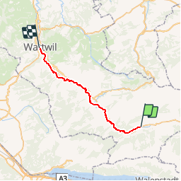
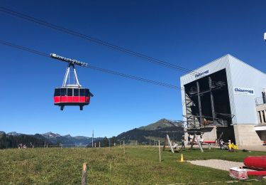
Randonnée Autre activité de 25 km à découvrir à Saint-Gall, Wahlkreis Toggenburg, Wildhaus-Alt St. Johann. Cette randonnée est proposée par hallauer.
Description
Der Pilgerweg führt hier über die ganze Strecke auf der "SchweizMobil - Route 24" THURWEG
Localisation
Pays :
Suisse
Région :
Saint-Gall
Département/Province :
Wahlkreis Toggenburg
Commune :
Wildhaus-Alt St. Johann
Localité :
Unknown
Départ:(Dec)
Départ:(UTM)
521547 ; 5226791 (32T) N.
Commentaires
Randonnées à proximité
![Randonnée A pied Grabs - Geologischer Rundweg Gamserrugg - Photo](https://media.geolcdn.com/t/375/260/22bf82fc-0ce7-45ad-b119-a1dbe35e1654.jpeg&format=jpg&maxdim=2)
![A pied A pied](https://static1.geolcdn.com/sitytour/trail-icons/100.png)
Geologischer Rundweg Gamserrugg
A pied
Facile
Grabs,
Saint-Gall,
Wahlkreis Werdenberg,
Suisse
![](/images/other/stat-length.png)
5,1 km | 8,1 km-effort
1h 50min
![](https://static1.geolcdn.com/siteimages/upload/files/16400158638029165_repeat_loop_refresh_sync_direction_icon.png)
Oui
![Randonnée A pied Wildhaus-Alt St. Johann - Unterwasser-Halden-Egerten-Gräppelensee - Photo](https://media.geolcdn.com/t/375/260/35e5a00e-49e6-4b57-bd90-3eb5018a0ac1.jpeg&format=jpg&maxdim=2)
![A pied A pied](https://static1.geolcdn.com/sitytour/trail-icons/100.png)
Unterwasser-Halden-Egerten-Gräppelensee
A pied
Facile
Wildhaus-Alt St. Johann,
Saint-Gall,
Wahlkreis Toggenburg,
Suisse
![](/images/other/stat-length.png)
3,9 km | 8,4 km-effort
1h 54min
![](https://static1.geolcdn.com/siteimages/upload/files/16400158638029165_repeat_loop_refresh_sync_direction_icon.png)
Non
![Randonnée A pied Wildhaus-Alt St. Johann - Sagenweg - Photo](https://media.geolcdn.com/t/375/260/039edbbf-db49-4f16-95e5-54c44d2e1a4f.jpeg&format=jpg&maxdim=2)
![A pied A pied](https://static1.geolcdn.com/sitytour/trail-icons/100.png)
Sagenweg
A pied
Facile
Wildhaus-Alt St. Johann,
Saint-Gall,
Wahlkreis Toggenburg,
Suisse
![](/images/other/stat-length.png)
11,3 km | 16,5 km-effort
3h 45min
![](https://static1.geolcdn.com/siteimages/upload/files/16400158638029165_repeat_loop_refresh_sync_direction_icon.png)
Oui
![Randonnée A pied Wildhaus-Alt St. Johann - Klangweg - Photo](https://media.geolcdn.com/t/375/260/fc04d86b-e504-4363-83a7-958513154a67.jpeg&format=jpg&maxdim=2)
![A pied A pied](https://static1.geolcdn.com/sitytour/trail-icons/100.png)
Klangweg
A pied
Facile
Wildhaus-Alt St. Johann,
Saint-Gall,
Wahlkreis Toggenburg,
Suisse
![](/images/other/stat-length.png)
3,9 km | 5,3 km-effort
1h 12min
![](https://static1.geolcdn.com/siteimages/upload/files/16400158638029165_repeat_loop_refresh_sync_direction_icon.png)
Non
![Randonnée A pied Wildhaus-Alt St. Johann - Langenbüel - Rotsteinpass - Photo](https://media.geolcdn.com/t/375/260/dev_d15d20b2-d56c-4313-8ed8-a77c1b44e9b5.jpeg&format=jpg&maxdim=2)
![A pied A pied](https://static1.geolcdn.com/sitytour/trail-icons/100.png)
Langenbüel - Rotsteinpass
A pied
Facile
Wildhaus-Alt St. Johann,
Saint-Gall,
Wahlkreis Toggenburg,
Suisse
![](/images/other/stat-length.png)
3,2 km | 9,5 km-effort
2h 9min
![](https://static1.geolcdn.com/siteimages/upload/files/16400158638029165_repeat_loop_refresh_sync_direction_icon.png)
Non
![Randonnée Marche Wildhaus-Alt St. Johann - . Oberdorf - Strichboden en passant Chäserrugg - Photo](https://media.geolcdn.com/t/375/260/6b56bd3a-2807-4370-a942-31e304753a78.jpg&format=jpg&maxdim=2)
![Marche Marche](https://static1.geolcdn.com/sitytour/trail-icons/101.png)
. Oberdorf - Strichboden en passant Chäserrugg
Marche
Moyen
Wildhaus-Alt St. Johann,
Saint-Gall,
Wahlkreis Toggenburg,
Suisse
![](/images/other/stat-length.png)
21 km | 42 km-effort
6h 9min
![](https://static1.geolcdn.com/siteimages/upload/files/16400158638029165_repeat_loop_refresh_sync_direction_icon.png)
Non
![Randonnée Autre activité Wildhaus-Alt St. Johann - y10_Klangweg_Toggenburg - Photo](https://media.geolcdn.com/t/375/260/ext.jpg?maxdim=2&url=https%3A%2F%2Fstatic1.geolcdn.com%2Fsiteimages%2Fupload%2Ffiles%2F1545311037marcheuse_200dpi.jpg)
![Autre activité Autre activité](https://static1.geolcdn.com/sitytour/trail-icons/900.png)
y10_Klangweg_Toggenburg
Autre activité
Très facile
Wildhaus-Alt St. Johann,
Saint-Gall,
Wahlkreis Toggenburg,
Suisse
![](/images/other/stat-length.png)
6 km | 8,5 km-effort
1h 59min
![](https://static1.geolcdn.com/siteimages/upload/files/16400158638029165_repeat_loop_refresh_sync_direction_icon.png)
Non
![Randonnée Autre activité Wildhaus-Alt St. Johann - y10_selun - Photo](https://media.geolcdn.com/t/375/260/ext.jpg?maxdim=2&url=https%3A%2F%2Fstatic1.geolcdn.com%2Fsiteimages%2Fupload%2Ffiles%2F1545311037marcheuse_200dpi.jpg)
![Autre activité Autre activité](https://static1.geolcdn.com/sitytour/trail-icons/900.png)
y10_selun
Autre activité
Très facile
Wildhaus-Alt St. Johann,
Saint-Gall,
Wahlkreis Toggenburg,
Suisse
![](/images/other/stat-length.png)
10,7 km | 21 km-effort
4h 49min
![](https://static1.geolcdn.com/siteimages/upload/files/16400158638029165_repeat_loop_refresh_sync_direction_icon.png)
Non
![Randonnée Autre activité Wildhaus-Alt St. Johann - y10_hinterrugg - Photo](https://media.geolcdn.com/t/375/260/ext.jpg?maxdim=2&url=https%3A%2F%2Fstatic1.geolcdn.com%2Fsiteimages%2Fupload%2Ffiles%2F1545311037marcheuse_200dpi.jpg)
![Autre activité Autre activité](https://static1.geolcdn.com/sitytour/trail-icons/900.png)
y10_hinterrugg
Autre activité
Très facile
Wildhaus-Alt St. Johann,
Saint-Gall,
Wahlkreis Toggenburg,
Suisse
![](/images/other/stat-length.png)
5,4 km | 15,2 km-effort
3h 59min
![](https://static1.geolcdn.com/siteimages/upload/files/16400158638029165_repeat_loop_refresh_sync_direction_icon.png)
Non