![](/images/other/stat-length.png)
![Randonnée Marche Sénezergues - promenade de la noix à Senezergues - Photo](https://media.geolcdn.com/t/1900/400/ext.pjpeg?maxdim=2&url=https%3A%2F%2Fstatic1.geolcdn.com%2Fsiteimages%2Fupload%2Ffiles%2F1553511878bg_sport_marche.png)
promenade de la noix à Senezergues
alainlissac
Utilisateur
![Longueur](/images/other/stat-length.png)
Longueur
10,9 km
![Altitude max](https://static1.geolcdn.com/siteimages/upload/files/1508320355ic_sort_altitude_max_24dp.png)
Altitude max
600 m
![Dénivelé positif](https://static1.geolcdn.com/siteimages/upload/files/1508320355ic_sort_den_pos_24dp.png)
Dénivelé positif
322 m
![Km-Effort](/images/other/stat-length.png)
Km-Effort
15,2 km
![Altitude min](https://static1.geolcdn.com/siteimages/upload/files/1508320355ic_sort_altitude_min_24dp.png)
Altitude min
363 m
![Dénivelé négatif](https://static1.geolcdn.com/siteimages/upload/files/1508320355ic_sort_den_neg_24dp.png)
Dénivelé négatif
323 m
![Boucle](https://static1.geolcdn.com/siteimages/upload/files/16400158638029165_repeat_loop_refresh_sync_direction_icon.png)
Boucle
Oui
Date de création :
2014-12-10 00:00:00.0
Dernière modification :
2014-12-10 00:00:00.0
![Marche](https://static1.geolcdn.com/sitytour/trail-icons/101.png)
3h27
Difficulté : Moyen
![Scannez ce code QR pour ouvrir la randonnée dans l'application SityTrail](https://capi.geolives.com/qq0zvz2zws4bq2lad0pu/sitytour/trails/222729/qr.png?size=200)
Application GPS de randonnée GRATUITE
À propos
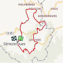
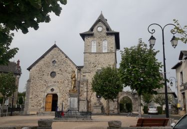
Randonnée Marche de 10,9 km à découvrir à Auvergne-Rhône-Alpes, Cantal, Sénezergues. Cette randonnée est proposée par alainlissac.
Description
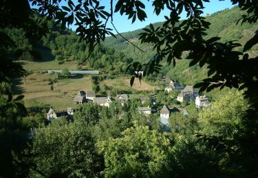
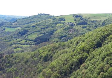
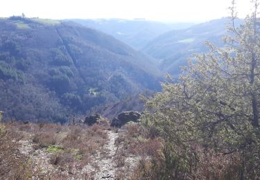
Jolie balade qui passe par les villages du Camas ,du Bouscal et de Leygues avec vue sur le Venazes et Junhac,sur la vallée de l Auze et le château de Senezergues
Localisation
Pays :
France
Région :
Auvergne-Rhône-Alpes
Département/Province :
Cantal
Commune :
Sénezergues
Localité :
Unknown
Départ:(Dec)
Départ:(UTM)
453495 ; 4950142 (31T) N.
Commentaires
Randonnées à proximité
![Randonnée V.T.T. Puycapel - Dans les bois de Calvinet - La Roubine - Photo](https://media.geolcdn.com/t/375/260/ext.jpg?maxdim=2&url=https%3A%2F%2Fstatic1.geolcdn.com%2Fsiteimages%2Fupload%2Ffiles%2F1524743154velo.jpg)
![V.T.T. V.T.T.](https://static1.geolcdn.com/sitytour/trail-icons/202.png)
Dans les bois de Calvinet - La Roubine
V.T.T.
Moyen
(1)
Puycapel,
Auvergne-Rhône-Alpes,
Cantal,
France
![](/images/other/stat-length.png)
24 km | 32 km-effort
2h 30min
![](https://static1.geolcdn.com/siteimages/upload/files/16400158638029165_repeat_loop_refresh_sync_direction_icon.png)
Oui
![Randonnée Marche Cassaniouze - cassaniouze st projet - Photo](https://media.geolcdn.com/t/375/260/cf472bcd-a1d4-4331-a68b-71f36b5812e9.jpg&format=jpg&maxdim=2)
![Marche Marche](https://static1.geolcdn.com/sitytour/trail-icons/101.png)
cassaniouze st projet
Marche
Très difficile
Cassaniouze,
Auvergne-Rhône-Alpes,
Cantal,
France
![](/images/other/stat-length.png)
13,6 km | 22 km-effort
2h 39min
![](https://static1.geolcdn.com/siteimages/upload/files/16400158638029165_repeat_loop_refresh_sync_direction_icon.png)
Oui
![Randonnée Marche Cassaniouze - cassaniouze st projet - Photo](https://media.geolcdn.com/t/375/260/ext.jpg?maxdim=2&url=https%3A%2F%2Fservices.sitytrail.com%2FGeolivesWS%2FDownloadMedia.ashx%3FTrailID%3D953395%26Media%3Dfix__20180428180335.jpg)
![Marche Marche](https://static1.geolcdn.com/sitytour/trail-icons/101.png)
cassaniouze st projet
Marche
Moyen
Cassaniouze,
Auvergne-Rhône-Alpes,
Cantal,
France
![](/images/other/stat-length.png)
15,2 km | 24 km-effort
3h 52min
![](https://static1.geolcdn.com/siteimages/upload/files/16400158638029165_repeat_loop_refresh_sync_direction_icon.png)
Oui
![Randonnée Marche Cassaniouze - Cassaniouze - St Projet - Le chateau de Roquemaurel - Photo](https://media.geolcdn.com/t/375/260/ext.jpg?maxdim=2&url=https%3A%2F%2Fservices.sitytrail.com%2FGeolivesWS%2FDownloadMedia.ashx%3FTrailID%3D105319%26Media%3D9010_2.jpg)
![Marche Marche](https://static1.geolcdn.com/sitytour/trail-icons/101.png)
Cassaniouze - St Projet - Le chateau de Roquemaurel
Marche
Difficile
Cassaniouze,
Auvergne-Rhône-Alpes,
Cantal,
France
![](/images/other/stat-length.png)
15,6 km | 26 km-effort
4h 0min
![](https://static1.geolcdn.com/siteimages/upload/files/16400158638029165_repeat_loop_refresh_sync_direction_icon.png)
Oui
![Randonnée Marche Sansac-Veinazès - Rando à Sansac Veinazés - Photo](https://media.geolcdn.com/t/375/260/ext.jpg?maxdim=2&url=https%3A%2F%2Fservices.sitytrail.com%2FGeolivesWS%2FDownloadMedia.ashx%3FTrailID%3D103696%26Media%3D6185_1.jpg)
![Marche Marche](https://static1.geolcdn.com/sitytour/trail-icons/101.png)
Rando à Sansac Veinazés
Marche
Moyen
Sansac-Veinazès,
Auvergne-Rhône-Alpes,
Cantal,
France
![](/images/other/stat-length.png)
8 km | 10,9 km-effort
2h 0min
![](https://static1.geolcdn.com/siteimages/upload/files/16400158638029165_repeat_loop_refresh_sync_direction_icon.png)
Oui
![Randonnée Marche Cassaniouze - Camping Le Cantalou - Photo](https://media.geolcdn.com/t/375/260/ext.jpg?maxdim=2&url=https%3A%2F%2Fstatic1.geolcdn.com%2Fsiteimages%2Fupload%2Ffiles%2F1553511878bg_sport_marche.png)
![Marche Marche](https://static1.geolcdn.com/sitytour/trail-icons/101.png)
Camping Le Cantalou
Marche
Facile
Cassaniouze,
Auvergne-Rhône-Alpes,
Cantal,
France
![](/images/other/stat-length.png)
5,7 km | 6,9 km-effort
1h 15min
![](https://static1.geolcdn.com/siteimages/upload/files/16400158638029165_repeat_loop_refresh_sync_direction_icon.png)
Oui
![Randonnée Marche Puycapel - la rouquette - Photo](https://media.geolcdn.com/t/375/260/ext.jpg?maxdim=2&url=https%3A%2F%2Fstatic1.geolcdn.com%2Fsiteimages%2Fupload%2Ffiles%2F1553511878bg_sport_marche.png)
![Marche Marche](https://static1.geolcdn.com/sitytour/trail-icons/101.png)
la rouquette
Marche
Moyen
Puycapel,
Auvergne-Rhône-Alpes,
Cantal,
France
![](/images/other/stat-length.png)
8,5 km | 10,7 km-effort
1h 28min
![](https://static1.geolcdn.com/siteimages/upload/files/16400158638029165_repeat_loop_refresh_sync_direction_icon.png)
Oui
![Randonnée Marche nordique Cassaniouze - cassaniouze servant - Photo](https://media.geolcdn.com/t/375/260/22d64793-a5d5-46b7-8295-f662d4245d86.jpg&format=jpg&maxdim=2)
![Marche nordique Marche nordique](https://static1.geolcdn.com/sitytour/trail-icons/102.png)
cassaniouze servant
Marche nordique
Difficile
Cassaniouze,
Auvergne-Rhône-Alpes,
Cantal,
France
![](/images/other/stat-length.png)
10,7 km | 14,9 km-effort
2h 4min
![](https://static1.geolcdn.com/siteimages/upload/files/16400158638029165_repeat_loop_refresh_sync_direction_icon.png)
Oui
![Randonnée A pied Cassaniouze - cassaniouze servant - Photo](https://media.geolcdn.com/t/375/260/17de722d-0bab-4cd1-b4ea-68bc4e5fab46.jpg&format=jpg&maxdim=2)
![A pied A pied](https://static1.geolcdn.com/sitytour/trail-icons/100.png)
cassaniouze servant
A pied
Moyen
Cassaniouze,
Auvergne-Rhône-Alpes,
Cantal,
France
![](/images/other/stat-length.png)
8 km | 11,2 km-effort
Inconnu
![](https://static1.geolcdn.com/siteimages/upload/files/16400158638029165_repeat_loop_refresh_sync_direction_icon.png)
Oui
Belle randonnée. Plusieurs passage dans des propriétés privées. Y a t'il une autorisation des propriétaires ?