![](/images/other/stat-length.png)
![Randonnée A pied Dinant - Chemin des Crêtes - Photo](https://media.geolcdn.com/t/1900/400/ext.pjpeg?maxdim=2&url=https%3A%2F%2Fstatic1.geolcdn.com%2Fsiteimages%2Fupload%2Ffiles%2F1545311037marcheuse_200dpi.jpg)
Chemin des Crêtes
ValleedelaMeuse
Utilisateur
![Longueur](/images/other/stat-length.png)
Longueur
12 km
![Altitude max](https://static1.geolcdn.com/siteimages/upload/files/1508320355ic_sort_altitude_max_24dp.png)
Altitude max
248 m
![Dénivelé positif](https://static1.geolcdn.com/siteimages/upload/files/1508320355ic_sort_den_pos_24dp.png)
Dénivelé positif
321 m
![Km-Effort](/images/other/stat-length.png)
Km-Effort
16,3 km
![Altitude min](https://static1.geolcdn.com/siteimages/upload/files/1508320355ic_sort_altitude_min_24dp.png)
Altitude min
89 m
![Dénivelé négatif](https://static1.geolcdn.com/siteimages/upload/files/1508320355ic_sort_den_neg_24dp.png)
Dénivelé négatif
321 m
![Boucle](https://static1.geolcdn.com/siteimages/upload/files/16400158638029165_repeat_loop_refresh_sync_direction_icon.png)
Boucle
Oui
Date de création :
2019-10-07 12:47:07.83
Dernière modification :
2019-10-07 12:55:20.564
![A pied](https://static1.geolcdn.com/sitytour/trail-icons/100.png)
4h20
Difficulté : Très difficile
![Scannez ce code QR pour ouvrir la randonnée dans l'application SityTrail](https://capi.geolives.com/qq0zvz2zws4bq2lad0pu/sitytour/trails/2224142/qr.png?size=200)
Application GPS de randonnée GRATUITE
À propos
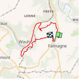
Randonnée A pied de 12 km à découvrir à Wallonie, Namur, Dinant. Cette randonnée est proposée par ValleedelaMeuse.
Description
au départ du parking de Falmignoul, vous parcourez différents chemin à travers champs puis à travers bois en direction des Cascatelles.En bord de Meuse ,vous longez la rive droite sur environ 2 km.Remontez dans les bois par le GR126 pour enfin atteindre le village.
Localisation
Pays :
Belgique
Région :
Wallonie
Département/Province :
Namur
Commune :
Dinant
Localité :
Falmignoul
Départ:(Dec)
Départ:(UTM)
635146 ; 5562944 (31U) N.
Commentaires
Randonnées à proximité
![Marche Marche](https://static1.geolcdn.com/sitytour/trail-icons/101.png)
RB-Na-24_Anseremme
Marche
Très difficile
(15)
Dinant,
Wallonie,
Namur,
Belgique
![](/images/other/stat-length.png)
19,3 km | 26 km-effort
5h 57min
![](https://static1.geolcdn.com/siteimages/upload/files/16400158638029165_repeat_loop_refresh_sync_direction_icon.png)
Oui
![Randonnée Marche Hastière - Balade de Hastière à Waulsort - Photo](https://media.geolcdn.com/t/375/260/ext.jpg?maxdim=2&url=https%3A%2F%2Fservices.sitytrail.com%2FGeolivesWS%2FDownloadMedia.ashx%3FTrailID%3D387141%26Media%3D8deb5256-25c7-4e2f-8aa7-6385d313d678.JPG)
![Marche Marche](https://static1.geolcdn.com/sitytour/trail-icons/101.png)
Balade de Hastière à Waulsort
Marche
Moyen
(2)
Hastière,
Wallonie,
Namur,
Belgique
![](/images/other/stat-length.png)
10,8 km | 13,8 km-effort
3h 2min
![](https://static1.geolcdn.com/siteimages/upload/files/16400158638029165_repeat_loop_refresh_sync_direction_icon.png)
Oui
![Randonnée Marche Dinant - D'Anseremme à Dinant - Photo](https://media.geolcdn.com/t/375/260/ext.jpg?maxdim=2&url=https%3A%2F%2Fservices.sitytrail.com%2FGeolivesWS%2FDownloadMedia.ashx%3FTrailID%3D375788%26Media%3D9ffb86bd-da6e-4936-82b7-07dbdf349394.JPG)
![Marche Marche](https://static1.geolcdn.com/sitytour/trail-icons/101.png)
D'Anseremme à Dinant
Marche
Facile
(3)
Dinant,
Wallonie,
Namur,
Belgique
![](/images/other/stat-length.png)
8,3 km | 11,8 km-effort
2h 34min
![](https://static1.geolcdn.com/siteimages/upload/files/16400158638029165_repeat_loop_refresh_sync_direction_icon.png)
Oui
![Randonnée Marche Hastière - RB-Na-10_Hastière-racc2 - Photo](https://media.geolcdn.com/t/375/260/ext.jpg?maxdim=2&url=https%3A%2F%2Fservices.sitytrail.com%2FGeolivesWS%2FDownloadMedia.ashx%3FTrailID%3D213761%26Media%3D916a806e-df9c-467d-9e17-3d2c79318b74.jpg)
![Marche Marche](https://static1.geolcdn.com/sitytour/trail-icons/101.png)
RB-Na-10_Hastière-racc2
Marche
Facile
(2)
Hastière,
Wallonie,
Namur,
Belgique
![](/images/other/stat-length.png)
18,1 km | 25 km-effort
4h 29min
![](https://static1.geolcdn.com/siteimages/upload/files/16400158638029165_repeat_loop_refresh_sync_direction_icon.png)
Oui
![Randonnée Marche Hastière - RB-Na-10_Hastière-racc1 - Photo](https://media.geolcdn.com/t/375/260/ext.jpg?maxdim=2&url=https%3A%2F%2Fservices.sitytrail.com%2FGeolivesWS%2FDownloadMedia.ashx%3FTrailID%3D213760%26Media%3D343ebbcb-0af7-4afb-9c83-addaf37a523a.jpg)
![Marche Marche](https://static1.geolcdn.com/sitytour/trail-icons/101.png)
RB-Na-10_Hastière-racc1
Marche
Moyen
(3)
Hastière,
Wallonie,
Namur,
Belgique
![](/images/other/stat-length.png)
15,3 km | 21 km-effort
5h 28min
![](https://static1.geolcdn.com/siteimages/upload/files/16400158638029165_repeat_loop_refresh_sync_direction_icon.png)
Oui
![Randonnée Marche Hastière - RB-Na-10_Hastière - Photo](https://media.geolcdn.com/t/375/260/ext.jpg?maxdim=2&url=https%3A%2F%2Fservices.sitytrail.com%2FGeolivesWS%2FDownloadMedia.ashx%3FTrailID%3D179636%26Media%3Db1540aaa-f9ca-4d3f-a5e9-5e8de7ac00b3.jpg)
![Marche Marche](https://static1.geolcdn.com/sitytour/trail-icons/101.png)
RB-Na-10_Hastière
Marche
Moyen
(5)
Hastière,
Wallonie,
Namur,
Belgique
![](/images/other/stat-length.png)
22 km | 29 km-effort
6h 21min
![](https://static1.geolcdn.com/siteimages/upload/files/16400158638029165_repeat_loop_refresh_sync_direction_icon.png)
Oui
![Marche Marche](https://static1.geolcdn.com/sitytour/trail-icons/101.png)
RB-Na-24_Anseremme_via-racc
Marche
Très difficile
(4)
Dinant,
Wallonie,
Namur,
Belgique
![](/images/other/stat-length.png)
18,5 km | 24 km-effort
5h 29min
![](https://static1.geolcdn.com/siteimages/upload/files/16400158638029165_repeat_loop_refresh_sync_direction_icon.png)
Oui
![Randonnée Marche Dinant - FURFFOZ ... les Aiguilles de Chaleux et la Réserve naturelle. - Photo](https://media.geolcdn.com/t/375/260/5397ac9f-a7ea-4ef6-be10-3fc6907b1e23.jpg&format=jpg&maxdim=2)
![Marche Marche](https://static1.geolcdn.com/sitytour/trail-icons/101.png)
FURFFOZ ... les Aiguilles de Chaleux et la Réserve naturelle.
Marche
Facile
(6)
Dinant,
Wallonie,
Namur,
Belgique
![](/images/other/stat-length.png)
9,6 km | 12,9 km-effort
1h 38min
![](https://static1.geolcdn.com/siteimages/upload/files/16400158638029165_repeat_loop_refresh_sync_direction_icon.png)
Oui
![Randonnée Marche Dinant - ANSEREMME (Passerelle) - Photo](https://media.geolcdn.com/t/375/260/ext.jpg?maxdim=2&url=https%3A%2F%2Fservices.sitytrail.com%2FGeolivesWS%2FDownloadMedia.ashx%3FTrailID%3D525086%26Media%3Dfix__20160213155638.jpg)
![Marche Marche](https://static1.geolcdn.com/sitytour/trail-icons/101.png)
ANSEREMME (Passerelle)
Marche
Facile
(4)
Dinant,
Wallonie,
Namur,
Belgique
![](/images/other/stat-length.png)
11,6 km | 15 km-effort
3h 15min
![](https://static1.geolcdn.com/siteimages/upload/files/16400158638029165_repeat_loop_refresh_sync_direction_icon.png)
Oui