![](/images/other/stat-length.png)
![Randonnée A pied Dinant - Bois d' Hulbise - Photo](https://media.geolcdn.com/t/1900/400/ext.pjpeg?maxdim=2&url=https%3A%2F%2Fstatic1.geolcdn.com%2Fsiteimages%2Fupload%2Ffiles%2F1545311037marcheuse_200dpi.jpg)
Bois d' Hulbise
ValleedelaMeuse
Utilisateur
![Longueur](/images/other/stat-length.png)
Longueur
10,5 km
![Altitude max](https://static1.geolcdn.com/siteimages/upload/files/1508320355ic_sort_altitude_max_24dp.png)
Altitude max
272 m
![Dénivelé positif](https://static1.geolcdn.com/siteimages/upload/files/1508320355ic_sort_den_pos_24dp.png)
Dénivelé positif
149 m
![Km-Effort](/images/other/stat-length.png)
Km-Effort
12,4 km
![Altitude min](https://static1.geolcdn.com/siteimages/upload/files/1508320355ic_sort_altitude_min_24dp.png)
Altitude min
188 m
![Dénivelé négatif](https://static1.geolcdn.com/siteimages/upload/files/1508320355ic_sort_den_neg_24dp.png)
Dénivelé négatif
148 m
![Boucle](https://static1.geolcdn.com/siteimages/upload/files/16400158638029165_repeat_loop_refresh_sync_direction_icon.png)
Boucle
Oui
Date de création :
2019-10-07 07:36:37.468
Dernière modification :
2019-10-07 07:42:36.463
![A pied](https://static1.geolcdn.com/sitytour/trail-icons/100.png)
3h00
Difficulté : Facile
![Scannez ce code QR pour ouvrir la randonnée dans l'application SityTrail](https://capi.geolives.com/qq0zvz2zws4bq2lad0pu/sitytour/trails/2223862/qr.png?size=200)
Application GPS de randonnée GRATUITE
À propos
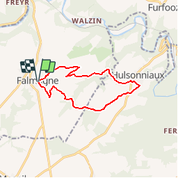
Randonnée A pied de 10,5 km à découvrir à Wallonie, Namur, Dinant. Cette randonnée est proposée par ValleedelaMeuse.
Description
Départ de l' église de Falmagne vers le grand Cortil puis on alterne entre champs et bois jusqu'à Hulsonniaux. Retour par le bois d'Hulbise et le Ry de Vesse vers le village.
Localisation
Pays :
Belgique
Région :
Wallonie
Département/Province :
Namur
Commune :
Dinant
Localité :
Falmagne
Départ:(Dec)
Départ:(UTM)
635433 ; 5562583 (31U) N.
Commentaires
Randonnées à proximité
![Marche Marche](https://static1.geolcdn.com/sitytour/trail-icons/101.png)
RB-Na-24_Anseremme
Marche
Très difficile
(15)
Dinant,
Wallonie,
Namur,
Belgique
![](/images/other/stat-length.png)
19,3 km | 26 km-effort
5h 57min
![](https://static1.geolcdn.com/siteimages/upload/files/16400158638029165_repeat_loop_refresh_sync_direction_icon.png)
Oui
![Randonnée Marche Houyet - RL-GG-20_Gendron_Dinant - Photo](https://media.geolcdn.com/t/375/260/ab939ff5-5b33-43fd-b036-e462abc33a68.jpg&format=jpg&maxdim=2)
![Marche Marche](https://static1.geolcdn.com/sitytour/trail-icons/101.png)
RL-GG-20_Gendron_Dinant
Marche
Très difficile
(6)
Houyet,
Wallonie,
Namur,
Belgique
![](/images/other/stat-length.png)
23 km | 30 km-effort
6h 27min
![](https://static1.geolcdn.com/siteimages/upload/files/16400158638029165_repeat_loop_refresh_sync_direction_icon.png)
Non
![Randonnée Marche Dinant - D'Anseremme à Dinant - Photo](https://media.geolcdn.com/t/375/260/ext.jpg?maxdim=2&url=https%3A%2F%2Fservices.sitytrail.com%2FGeolivesWS%2FDownloadMedia.ashx%3FTrailID%3D375788%26Media%3D9ffb86bd-da6e-4936-82b7-07dbdf349394.JPG)
![Marche Marche](https://static1.geolcdn.com/sitytour/trail-icons/101.png)
D'Anseremme à Dinant
Marche
Facile
(3)
Dinant,
Wallonie,
Namur,
Belgique
![](/images/other/stat-length.png)
8,3 km | 11,8 km-effort
2h 34min
![](https://static1.geolcdn.com/siteimages/upload/files/16400158638029165_repeat_loop_refresh_sync_direction_icon.png)
Oui
![Marche Marche](https://static1.geolcdn.com/sitytour/trail-icons/101.png)
RB-Na-24_Anseremme_via-racc
Marche
Très difficile
(4)
Dinant,
Wallonie,
Namur,
Belgique
![](/images/other/stat-length.png)
18,5 km | 24 km-effort
5h 29min
![](https://static1.geolcdn.com/siteimages/upload/files/16400158638029165_repeat_loop_refresh_sync_direction_icon.png)
Oui
![Randonnée Marche Dinant - FURFFOZ ... les Aiguilles de Chaleux et la Réserve naturelle. - Photo](https://media.geolcdn.com/t/375/260/5397ac9f-a7ea-4ef6-be10-3fc6907b1e23.jpg&format=jpg&maxdim=2)
![Marche Marche](https://static1.geolcdn.com/sitytour/trail-icons/101.png)
FURFFOZ ... les Aiguilles de Chaleux et la Réserve naturelle.
Marche
Facile
(6)
Dinant,
Wallonie,
Namur,
Belgique
![](/images/other/stat-length.png)
9,6 km | 12,9 km-effort
1h 38min
![](https://static1.geolcdn.com/siteimages/upload/files/16400158638029165_repeat_loop_refresh_sync_direction_icon.png)
Oui
![Randonnée Marche Dinant - ANSEREMME (Passerelle) - Photo](https://media.geolcdn.com/t/375/260/ext.jpg?maxdim=2&url=https%3A%2F%2Fservices.sitytrail.com%2FGeolivesWS%2FDownloadMedia.ashx%3FTrailID%3D525086%26Media%3Dfix__20160213155638.jpg)
![Marche Marche](https://static1.geolcdn.com/sitytour/trail-icons/101.png)
ANSEREMME (Passerelle)
Marche
Facile
(4)
Dinant,
Wallonie,
Namur,
Belgique
![](/images/other/stat-length.png)
11,6 km | 15 km-effort
3h 15min
![](https://static1.geolcdn.com/siteimages/upload/files/16400158638029165_repeat_loop_refresh_sync_direction_icon.png)
Oui
![Randonnée Marche Hastière - Waulsort - Circuit Natura 2000, des sites qui valent le détour - Na08 - Photo](https://media.geolcdn.com/t/375/260/ext.jpg?maxdim=2&url=https%3A%2F%2Fservices.sitytrail.com%2FGeolivesWS%2FDownloadMedia.ashx%3FTrailID%3D434736%26Media%3D6da8fd5b-7dc9-4341-8780-4fc280ddf4d9.JPG)
![Marche Marche](https://static1.geolcdn.com/sitytour/trail-icons/101.png)
Waulsort - Circuit Natura 2000, des sites qui valent le détour - Na08
Marche
Très facile
(4)
Hastière,
Wallonie,
Namur,
Belgique
![](/images/other/stat-length.png)
4,5 km | 6,9 km-effort
1h 40min
![](https://static1.geolcdn.com/siteimages/upload/files/16400158638029165_repeat_loop_refresh_sync_direction_icon.png)
Oui
![Randonnée Marche Houyet - la lesse de bas en haut - Photo](https://media.geolcdn.com/t/375/260/ext.jpg?maxdim=2&url=https%3A%2F%2Fservices.sitytrail.com%2FGeolivesWS%2FDownloadMedia.ashx%3FTrailID%3D315226%26Media%3Dfix__20140622124242.jpg)
![Marche Marche](https://static1.geolcdn.com/sitytour/trail-icons/101.png)
la lesse de bas en haut
Marche
Moyen
(3)
Houyet,
Wallonie,
Namur,
Belgique
![](/images/other/stat-length.png)
6,8 km | 9,1 km-effort
1h 21min
![](https://static1.geolcdn.com/siteimages/upload/files/16400158638029165_repeat_loop_refresh_sync_direction_icon.png)
Oui
![Randonnée Marche Hastière - Balade à Waulsort - Photo](https://media.geolcdn.com/t/375/260/430266b1-8cd2-4495-b460-1dbc4ae413f0.jpg&format=jpg&maxdim=2)
![Marche Marche](https://static1.geolcdn.com/sitytour/trail-icons/101.png)
Balade à Waulsort
Marche
Moyen
Hastière,
Wallonie,
Namur,
Belgique
![](/images/other/stat-length.png)
6,5 km | 8,6 km-effort
1h 56min
![](https://static1.geolcdn.com/siteimages/upload/files/16400158638029165_repeat_loop_refresh_sync_direction_icon.png)
Oui