![](/images/other/stat-length.png)
![Randonnée Marche Capoulet-et-Junac - Le Vicdessos par Illié - Photo](https://media.geolcdn.com/t/1900/400/ca761c83-3387-4b8c-a324-b7eee82e1103.jpg&format=pjpeg&maxdim=2)
Le Vicdessos par Illié
c.chehere
Utilisateur
![Longueur](/images/other/stat-length.png)
Longueur
14,3 km
![Altitude max](https://static1.geolcdn.com/siteimages/upload/files/1508320355ic_sort_altitude_max_24dp.png)
Altitude max
1102 m
![Dénivelé positif](https://static1.geolcdn.com/siteimages/upload/files/1508320355ic_sort_den_pos_24dp.png)
Dénivelé positif
718 m
![Km-Effort](/images/other/stat-length.png)
Km-Effort
24 km
![Altitude min](https://static1.geolcdn.com/siteimages/upload/files/1508320355ic_sort_altitude_min_24dp.png)
Altitude min
573 m
![Dénivelé négatif](https://static1.geolcdn.com/siteimages/upload/files/1508320355ic_sort_den_neg_24dp.png)
Dénivelé négatif
717 m
![Boucle](https://static1.geolcdn.com/siteimages/upload/files/16400158638029165_repeat_loop_refresh_sync_direction_icon.png)
Boucle
Oui
Date de création :
2019-10-04 06:49:42.473
Dernière modification :
2019-10-04 14:03:03.71
![Marche](https://static1.geolcdn.com/sitytour/trail-icons/101.png)
5h52
Difficulté : Moyen
![Scannez ce code QR pour ouvrir la randonnée dans l'application SityTrail](https://capi.geolives.com/qq0zvz2zws4bq2lad0pu/sitytour/trails/2221624/qr.png?size=200)
Application GPS de randonnée GRATUITE
À propos
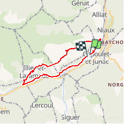
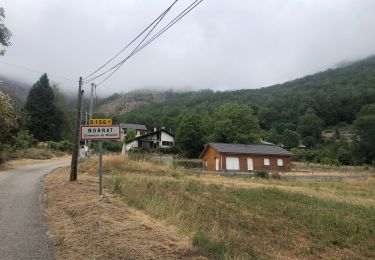
Randonnée Marche de 14,3 km à découvrir à Occitanie, Ariège, Capoulet-et-Junac. Cette randonnée est proposée par c.chehere.
Description
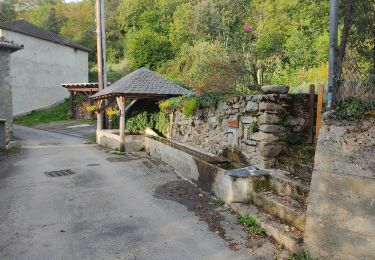
Départ depuis le cimetière de Junac.
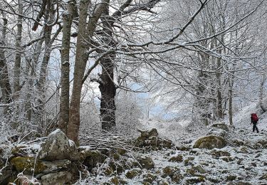
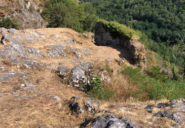
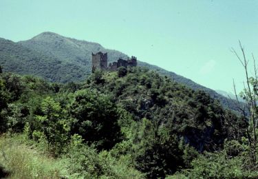
Belles vues sur le vicdessos et les trois seigneurs depuis le sentier en balcon.
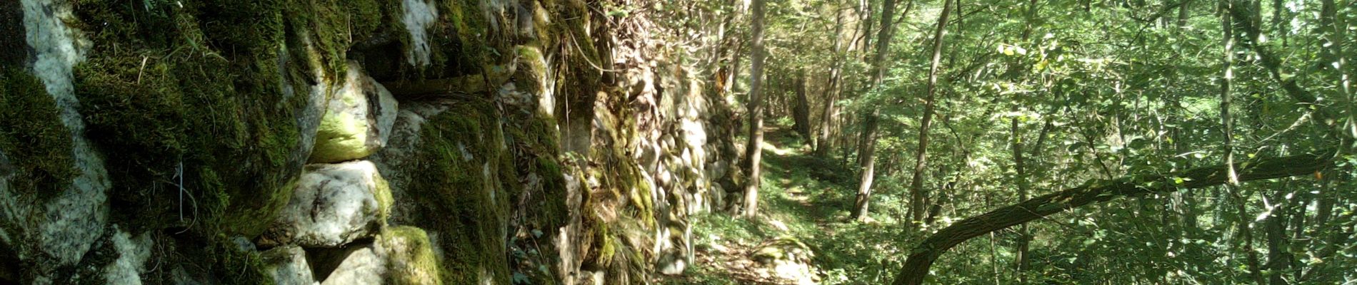
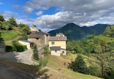
Redescente sur la vallée par un bon sentier bien tracé
Localisation
Pays :
France
Région :
Occitanie
Département/Province :
Ariège
Commune :
Capoulet-et-Junac
Localité :
Unknown
Départ:(Dec)
Départ:(UTM)
383848 ; 4739149 (31T) N.
Commentaires
Randonnées à proximité
![Randonnée Marche Gourbit - 04/06/2014 Rando Etang d'Artax - Photo](https://media.geolcdn.com/t/375/260/ext.jpg?maxdim=2&url=https%3A%2F%2Fservices.sitytrail.com%2FGeolivesWS%2FDownloadMedia.ashx%3FTrailID%3D308062%26Media%3D20140601132627.jpg)
![Marche Marche](https://static1.geolcdn.com/sitytour/trail-icons/101.png)
04/06/2014 Rando Etang d'Artax
Marche
Difficile
(1)
Gourbit,
Occitanie,
Ariège,
France
![](/images/other/stat-length.png)
10,8 km | 24 km-effort
2h 53min
![](https://static1.geolcdn.com/siteimages/upload/files/16400158638029165_repeat_loop_refresh_sync_direction_icon.png)
Oui
![Randonnée Vélo électrique Niaux - Niaux - Photo](https://media.geolcdn.com/t/375/260/2925b5db-f18d-4157-bbef-94a57335fc75.jpg&format=jpg&maxdim=2)
![Vélo électrique Vélo électrique](https://static1.geolcdn.com/sitytour/trail-icons/205.png)
![Randonnée Vélo électrique Niaux - Château Miglos - Photo](https://media.geolcdn.com/t/375/260/8bba2701-86a9-409d-bc1b-998f1da97a1d.jpg&format=jpg&maxdim=2)
![Vélo électrique Vélo électrique](https://static1.geolcdn.com/sitytour/trail-icons/205.png)
Château Miglos
Vélo électrique
Très facile
Niaux,
Occitanie,
Ariège,
France
![](/images/other/stat-length.png)
8,1 km | 11 km-effort
45min
![](https://static1.geolcdn.com/siteimages/upload/files/16400158638029165_repeat_loop_refresh_sync_direction_icon.png)
Non
![Randonnée A pied Lapège - Lapège et Pladetis - Photo](https://media.geolcdn.com/t/375/260/acf32a31-72a6-4e31-a909-32a8fa5a01b2.jpeg&format=jpg&maxdim=2)
![A pied A pied](https://static1.geolcdn.com/sitytour/trail-icons/100.png)
Lapège et Pladetis
A pied
Facile
Lapège,
Occitanie,
Ariège,
France
![](/images/other/stat-length.png)
10,1 km | 18,8 km-effort
4h 16min
![](https://static1.geolcdn.com/siteimages/upload/files/16400158638029165_repeat_loop_refresh_sync_direction_icon.png)
Non
![Randonnée A pied Illier-et-Laramade - D'Illier à Lapège - Photo](https://media.geolcdn.com/t/375/260/467a3965-d36a-44de-94c6-d7883cfb171b.jpeg&format=jpg&maxdim=2)
![A pied A pied](https://static1.geolcdn.com/sitytour/trail-icons/100.png)
D'Illier à Lapège
A pied
Facile
Illier-et-Laramade,
Occitanie,
Ariège,
France
![](/images/other/stat-length.png)
3,5 km | 5,3 km-effort
1h 11min
![](https://static1.geolcdn.com/siteimages/upload/files/16400158638029165_repeat_loop_refresh_sync_direction_icon.png)
Non
![Randonnée A pied Gourbit - Étang d'Artax - Photo](https://media.geolcdn.com/t/375/260/b2f84de2-fa0a-4b97-b201-829b16672ace.jpeg&format=jpg&maxdim=2)
![A pied A pied](https://static1.geolcdn.com/sitytour/trail-icons/100.png)
![Randonnée Marche Lercoul - Pic-de-garbie-de-bresoul-depuis-lercoul - Photo](https://media.geolcdn.com/t/375/260/82f09742-d952-478c-ab3a-a2125788a8a9.jpg&format=jpg&maxdim=2)
![Marche Marche](https://static1.geolcdn.com/sitytour/trail-icons/101.png)
Pic-de-garbie-de-bresoul-depuis-lercoul
Marche
Moyen
Lercoul,
Occitanie,
Ariège,
France
![](/images/other/stat-length.png)
14,7 km | 28 km-effort
6h 21min
![](https://static1.geolcdn.com/siteimages/upload/files/16400158638029165_repeat_loop_refresh_sync_direction_icon.png)
Oui
![Randonnée Marche Miglos - rocher de MIGLOS - Photo](https://media.geolcdn.com/t/375/260/50dd3b08-cf6c-423a-9a83-85e7a8a41a23.jpg&format=jpg&maxdim=2)
![Marche Marche](https://static1.geolcdn.com/sitytour/trail-icons/101.png)
![Randonnée Marche Larnat - Cap de la Lesse - Photo](https://media.geolcdn.com/t/375/260/92ac1c0a-3485-447b-b2e9-0e186b2c8c4a.jpg&format=jpg&maxdim=2)
![Marche Marche](https://static1.geolcdn.com/sitytour/trail-icons/101.png)